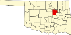
Milfay, Oklahoma

Last updated

Milfay, Oklahoma
USA Oklahoma location map.svg
Red pog.svg
Milfay
Location within the state of Oklahoma
Usa edcp location map.svg
Red pog.svg
Milfay
Milfay (the United States)
Coordinates: 35°45′06″N96°33′33″W / 35.75167°N 96.55917°W / 35.75167; -96.55917
Country United States
State Oklahoma
County Creek
Area
[1]
  Total0.64 sq mi (1.66 km2)
  Land0.63 sq mi (1.64 km2)
  Water0.01 sq mi (0.01 km2)
Elevation
[2]
837 ft (255 m)
Population
 (2020)
  Total74
  Density116.90/sq mi (45.11/km2)
Time zone UTC-6 (Central (CST))
  Summer (DST) UTC-5 (CDT)
FIPS code 40-48450
GNIS feature ID2805341 [2]

Milfay is a small unincorporated community in Creek County, Oklahoma, United States, about five and a half miles east of Stroud. [3] The post office was established December 14, 1911. The community was named after Charles Mills and Edward Fay, two railroad officials. [4]

Demographics

Historical population
CensusPop.Note
2020 74
U.S. Decennial Census [5]

Related Research Articles

<span class="mw-page-title-main">Oklahoma</span> U.S. state

Oklahoma is a state in the South Central region of the United States, bordered by the state of Texas to the south and west, Kansas to the north, Missouri to the northeast, Arkansas to the east, New Mexico to the west, and Colorado to the northwest. Partially in the western extreme of the Upland South, it is the 20th-most extensive and the 28th-most populous of the 50 United States. Its residents are known as Oklahomans and its capital and largest city is Oklahoma City. The state's name is derived from the Choctaw words okla, 'people' and humma, which translates as 'red'. Oklahoma is also known informally by its nickname, "The Sooner State", in reference to the Sooners, settlers who staked their claims in the Unassigned Lands before the Indian Appropriations Act of 1889 authorized the Land Rush of 1889.

<span class="mw-page-title-main">Oklahoma City</span> Capital city of Oklahoma, United States

Oklahoma City, officially the City of Oklahoma City, and often shortened to OKC, is the capital and largest city of the U.S. state of Oklahoma. The county seat of Oklahoma County, it ranks 20th among United States cities in population, and is the 8th largest city in the Southern United States. The population grew following the 2010 census and reached 681,054 in the 2020 census. The Oklahoma City metropolitan area had a population of 1,396,445, and the Oklahoma City–Shawnee Combined Statistical Area had a population of 1,469,124, making it Oklahoma's largest municipality and metropolitan area by population.

<span class="mw-page-title-main">Lincoln County, Oklahoma</span> County in Oklahoma, United States

Lincoln County is a county in eastern Central Oklahoma. As of the 2020 census, the population was 33,458. Its county seat is Chandler.

<span class="mw-page-title-main">Creek County, Oklahoma</span> County in Oklahoma, United States

Creek County is a county located in the U.S. state of Oklahoma. As of the 2020 census, the population was 71,754. Its county seat is Sapulpa.

<span class="mw-page-title-main">Cimarron County, Oklahoma</span> County in Oklahoma, United States

Cimarron County is the westernmost county in the U.S. state of Oklahoma. Its county seat is Boise City. As of the 2020 census, its population was 2,296, making it the least-populous county in Oklahoma; and indeed, throughout most of its history, it has had both the smallest population and the lowest population density of any county in Oklahoma. Located in the Oklahoma Panhandle, Cimarron County contains the only community in the state (Kenton) that observes the Mountain Time Zone. Black Mesa, the highest point in the state, is in the northwest corner of the county. The Cimarron County community of Regnier has the distinction of being the driest spot in Oklahoma ranked by lowest annual average precipitation, at just 15.62 inches; at the same time, Boise City is the snowiest location in Oklahoma ranked by highest annual average snowfall, at 31.6 inches.

<span class="mw-page-title-main">Cherokee County, Kansas</span> County in Kansas, United States

Cherokee County is a U.S. county located in Southeast Kansas. Its county seat is Columbus, and its most populous city is Baxter Springs. As of the 2020 census, the county population was 19,362. The county was named for the Cherokee tribe.

<span class="mw-page-title-main">Rogers, Arkansas</span> City in the United States

Rogers is a city in Benton County, Arkansas, United States. Located in the Ozarks, it is part of the Northwest Arkansas region, one of the fastest growing metro areas in the country. Rogers was the location of the first Walmart store, whose corporate headquarters is located in neighboring Bentonville. Daisy Outdoor Products, known for its air rifles, has both its headquarters and its Airgun Museum in Rogers. The city houses a popular shopping center, the Pinnacle Hills Promenade, and a music venue, the Walmart AMP, that has housed performances by big-name artists and local performers alike.

<span class="mw-page-title-main">Park Hill, Oklahoma</span> Census-designated place in Oklahoma, United States

Park Hill is an unincorporated community and census-designated place (CDP) in southwestern Cherokee County, Oklahoma, United States. The population was 3,909 at the 2010 census. It lies near Tahlequah, east of the junction of U.S. Route 62 and State Highway 82.

<span class="mw-page-title-main">Shamrock, Oklahoma</span> Town in Oklahoma, United States

Shamrock is an unincorporated community in Creek County, Oklahoma, United States, located on Oklahoma State Highway 16 south of Drumright and west-northwest of Bristow. The population was 65 at the time of the 2020 census. It was named for Shamrock, Illinois, the hometown of local store owner, James M. Thomas.

<span class="mw-page-title-main">Kingfisher, Oklahoma</span> City in Oklahoma, United States

Kingfisher is a city in and the county seat of Kingfisher County, Oklahoma,. The population was 4,903 at the time of the 2020 census. It is the former home and namesake of Kingfisher College. According to the Encyclopedia of Oklahoma History and Culture, Kingfisher is now primarily a bedroom community for people employed in Enid and Oklahoma City.

<span class="mw-page-title-main">Kendrick, Oklahoma</span> Town in Oklahoma, United States

Kendrick is a town in Lincoln County, Oklahoma, United States. The population was 139 at the 2010 census.

<span class="mw-page-title-main">Prague, Oklahoma</span> City in Oklahoma, United States

Prague is a city in Lincoln County, Oklahoma, United States. The population was 2,346 at the 2020 census, an 1.76 percent decrease from the figure of 2,388 in 2010. Czech immigrants founded the city, and named it after the capital of the present-day Czech Republic.

<span class="mw-page-title-main">Del City, Oklahoma</span> City in Oklahoma, United States

Del City is a city in Oklahoma County, Oklahoma, United States, and a part of the Oklahoma City metropolitan area. The population was 21,822 at the United States Census, 2020, a 2.3% increase from 2010.

<span class="mw-page-title-main">Miami, Oklahoma</span> City in Oklahoma, United States

Miami is a city in and county seat of Ottawa County, Oklahoma, United States, founded in 1891. Lead and zinc mining were established by 1918, causing the area's economy to boom.

<span class="mw-page-title-main">Tecumseh, Oklahoma</span> City in Oklahoma, United States

Tecumseh is a city in Pottawatomie County, Oklahoma. Its population was 6,457 at the 2010 census, a 5.9% increase from 6,098 in 2000. It was named for the noted Shawnee chief, Tecumseh. It was designated as the county seat at Oklahoma's statehood, but a county-wide election moved the seat to Shawnee in 1930.

<span class="mw-page-title-main">Stroud, Oklahoma</span> City in Oklahoma, United States

Stroud is a city in Creek and Lincoln counties in the U.S. state of Oklahoma. As of the 2010 census, the city population was 2,690.

<span class="mw-page-title-main">Owasso, Oklahoma</span> City in Oklahoma, United States

Owasso is a city in Rogers and Tulsa Counties in the U.S. state of Oklahoma, and the largest northern suburb of Tulsa. The population was 39,328 persons as of the 2022 census estimate, compared to 28,915 at the 2010 census, a gain of 36 percent. Originally settled in 1881 in Indian Territory, the town was incorporated in 1904 just before Oklahoma statehood and was chartered as a city in 1972.

Parkland is a small unincorporated community in northern Lincoln County, Oklahoma, United States. It is 4 miles (6 km) south of Agra. Its name was adopted "to describe the character of the townsite".

Kenwood is an unincorporated community and census-designated place (CDP) in Delaware and Mayes counties, Oklahoma, United States. As of the 2010 census it had a population of 1,224.

Nicut is an unincorporated community and census-designated place in Sequoyah County, Oklahoma, United States. Its population was 360 as of the 2010 census.

References

  1. "ArcGIS REST Services Directory". United States Census Bureau. Retrieved September 20, 2022.
  2. 1 2 U.S. Geological Survey Geographic Names Information System: Milfay, Oklahoma
  3. "Stroud, Oklahoma to Milfay, Oklahoma". Google Maps. Retrieved December 27, 2020.
  4. Shirk, George H (1987). Oklahoma Place Names. University of Oklahoma Press. ISBN   0-8061-2028-2.
  5. "Census of Population and Housing". Census.gov. Retrieved June 4, 2016.