Mounds, Oklahoma

Last updated

Mounds, Oklahoma
Creek County Oklahoma incorporated and unincorporated areas Mounds highlighted.svg
Location within Creek County, and the state of Oklahoma
Coordinates: 35°51′27″N96°08′10″W / 35.85750°N 96.13611°W / 35.85750; -96.13611
Country United States
State Oklahoma
County Creek
Area
[1]
  Total2.30 sq mi (5.95 km2)
  Land2.25 sq mi (5.82 km2)
  Water0.05 sq mi (0.13 km2)
Elevation
[2]
758 ft (231 m)
Population
 (2020)
  Total932
  Density414.96/sq mi (160.22/km2)
Time zone UTC-6 (Central (CST))
  Summer (DST) UTC-5 (CDT)
ZIP code
74047
Area code(s) 539/918
FIPS code 40-49550 [3]
GNIS feature ID2413017 [2]

Mounds is a town [4] in Creek County, Oklahoma, United States. It is located just south of Tulsa; the town's population was 932 at the 2020 census. [5]

Contents

History

The post office for this community was established in 1895 and originally named "Posey", for the Creek poet Alexander Posey, who lived in Eufaula, Oklahoma. In 1898, the town was moved 5 miles (8 km) southwest and renamed "Mounds" for twin hills that were nearby. By 1901, the St. Louis, Oklahoma and Southern Railway (later the St. Louis and San Francisco Railway) built a track through Mounds, and the town became an important cattle shipping point. Mounds incorporated as a city in the same year. The discovery of oil in the Glenn Pool field in 1905 turned Mounds into a shipping point for crude oil instead of cattle. [6]

In the early days, Mounds was on the route of the Sapulpa & Interurban Railway (“S&I”) streetcar/interurban line connecting to Tulsa through Sapulpa, Kiefer and Glenpool; S&I subsequently went through a series of mergers and name changes, with only the Tulsa-to-Sapulpa portion continuing as the Tulsa-Sapulpa Union Railway. [7]

Mounds had a population of 675 at statehood in 1907, rising to 701 in 1910. The oil boom played out in the 1920s, and the population declined from 1,078 in 1920 to 701 in 1930. Railroad activity became primarily shipping grain and cattle. As time went by, the population reached a low of 560 in 1950, since which it has increased. In the 21st century, Mounds is mostly a commuter town, with 92 percent of employed residents commuting to work primarily in Sapulpa and Tulsa. [6]

Geography

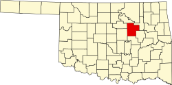
Mounds is located in eastern Creek County. U.S. Route 75A passes through the center of town, leading north 5 miles (8 km) to Kiefer and south 9 miles (14 km) to Beggs. Sapulpa, the Creek County seat, is 10 miles (16 km) north via U.S. 75A. U.S. Route 75 is 2.5 miles (4.0 km) east of Mounds via West 201st Street; downtown Tulsa is 22 miles (35 km) north of Mounds via U.S. 75.

According to the United States Census Bureau, the town of Mounds has a total area of 2.2 square miles (5.8 km2), of which 2.2 square miles (5.7 km2) is land and 0.04 square miles (0.1 km2), or 2.20%, is water. [8]

Demographics

Historical population
CensusPop.Note
1910 701
1920 1,07853.8%
1930 740−31.4%
1940 627−15.3%
1950 560−10.7%
1960 67420.4%
1970 76613.6%
1980 1,08641.8%
1990 980−9.8%
2000 1,15317.7%
2010 1,1681.3%
2020 932−20.2%
U.S. Decennial Census [9]

As of the census [3] of 2000, there were 1,153 people, 449 households, and 312 families residing in the town. The population density was 986.7 inhabitants per square mile (381.0/km2). There were 500 housing units at an average density of 427.9 per square mile (165.2/km2). The racial makeup of the town was 76.06% White, 1.21% African American, 15.61% Native American, 0.09% Asian, 1.21% from other races, and 5.81% from two or more races. Hispanic or Latino of any race were 1.82% of the population.

There were 449 households, out of which 34.1% had children under the age of 18 living with them, 50.6% were married couples living together, 12.2% had a female householder with no husband present, and 30.5% were non-families. 28.3% of all households were made up of individuals, and 15.4% had someone living alone who was 65 years of age or older. The average household size was 2.57 and the average family size was 3.10.

In the town, the population was spread out, with 29.3% under the age of 18, 9.1% from 18 to 24, 25.0% from 25 to 44, 22.4% from 45 to 64, and 14.2% who were 65 years of age or older. The median age was 35 years. For every 100 females, there were 93.5 males. For every 100 females age 18 and over, there were 92.2 males.

The median income for a household in the town was $27,050, and the median income for a family was $35,417. Males had a median income of $28,438 versus $18,750 for females. The per capita income for the town was $12,917. About 10.2% of families and 15.7% of the population were below the poverty line, including 17.5% of those under age 18 and 22.3% of those age 65 or over.

Education

Enrollment in the Mounds public school district serves about 300 pupils. The district's overall student/teacher ratio is 14.5:1. There are 2 schools associated with the agency, which is classified as being in or near a rural area. Mounds allocates approximately $2,854 per pupil for instructional expenses.

Mounds is the site of the ACT Observatory, a small astronomical observatory maintained by the Astronomy Club of Tulsa.

"Liberty Mounds"

There is no town of Liberty Mounds, despite the signs on US Route 75 pointing to Mounds on the west of the highway, and “Liberty Mounds” east of it. The town of Liberty, Oklahoma was originally incorporated in 1978 by the Spradling family precisely to avoid annexation of the area by other communities, including Mounds. The name was taken from the nearby Liberty School District, which a former school superintendent called “Liberty Mounds” to distinguish it from another Liberty school district near Morris in Okmulgee County. So the sign references the school, although both the town and the school district are actually named Liberty. [10] [11]

Notable people

Related Research Articles

<span class="mw-page-title-main">Tulsa County, Oklahoma</span> County in the United States

Tulsa County is located in the U.S. state of Oklahoma. As of the 2020 census, the population was 669,279, making it the second-most populous county in the state, behind only Oklahoma County. Its county seat and largest city is Tulsa, the second-largest city in the state. Founded at statehood, in 1907, it was named after the previously established city of Tulsa. Before statehood, the area was part of both the Creek Nation and the Cooweescoowee District of Cherokee Nation in Indian Territory.

<span class="mw-page-title-main">Okmulgee County, Oklahoma</span> County in Oklahoma, United States

Okmulgee County is a county in the U.S. state of Oklahoma. As of the 2020 census, the population was 36,706. The county seat is Okmulgee. Located within the Muscogee Nation Reservation, the county was created at statehood in 1907. The name Okmulgee is derived from the Hitchita word okimulgi, meaning "boiling waters".

<span class="mw-page-title-main">Creek County, Oklahoma</span> County in Oklahoma, United States

Creek County is a county located in the U.S. state of Oklahoma. As of the 2020 census, the population was 71,754. Its county seat is Sapulpa.

<span class="mw-page-title-main">Bristow, Oklahoma</span> City in Oklahoma, United States

Bristow is a city in Creek County, Oklahoma, United States. The population was 4,222 at the 2010 census, down 2.4 percent from the figure of 4,325 recorded in 2000.

<span class="mw-page-title-main">Depew, Oklahoma</span> Town in Oklahoma, United States

Depew is a town in Creek County, Oklahoma, United States. It is 41 miles southwest of Tulsa. The population was 411 at the 2020 census. The town was named in honor of New York Senator Chauncey Depew.

<span class="mw-page-title-main">Kellyville, Oklahoma</span> Town in Oklahoma, United States

Kellyville is a town in Creek County, Oklahoma, United States. The population was 1,019 at the 2020 census.

<span class="mw-page-title-main">Kiefer, Oklahoma</span> Town in Oklahoma, United States

Kiefer is a town in Creek County, Oklahoma, United States. The population was 2,187 at the 2020 census, a 30% increase over the 1,685 population recorded at the 2010 census, which itself was a 64 percent increase over the 1,026 figure recorded in 2000.

<span class="mw-page-title-main">Lawrence Creek, Oklahoma</span> Town in Oklahoma, United States

Lawrence Creek is a town in Creek County, Oklahoma, United States. Incorporated March 15, 1983, it is primarily a bedroom community whose employed residents work in Sapulpa and Tulsa. The population was 149 at the 2010 census, a gain of 25.2 percent over the figure of 119 recorded in 2000.

<span class="mw-page-title-main">Oilton, Oklahoma</span> City in Oklahoma, United States

Oilton is a city in Creek County, Oklahoma, United States. The population was 885 at the 2020 census, a 12.6% decline from the 1,013 recorded in 2010.

<span class="mw-page-title-main">Sapulpa, Oklahoma</span> City in Oklahoma, United States

Sapulpa is a city in Creek and Tulsa counties in the U.S. state of Oklahoma. The population was 21,929 at the time of the 2020 census, compared with 20,544 at the 2010 census. It is the county seat of Creek County.

<span class="mw-page-title-main">Shamrock, Oklahoma</span> Town in Oklahoma, United States

Shamrock is an unincorporated community in Creek County, Oklahoma, United States, located on Oklahoma State Highway 16 south of Drumright and west-northwest of Bristow. The population was 65 at the time of the 2020 census. It was named for Shamrock, Illinois, the hometown of local store owner, James M. Thomas.

<span class="mw-page-title-main">Slick, Oklahoma</span> Town in Oklahoma, United States

Slick is a town in Creek County, Oklahoma, United States. The population was 151 at the 2020 census, a 15.3% increase over the population in 2010.

<span class="mw-page-title-main">Warwick, Oklahoma</span> Town in Oklahoma, United States

Warwick is a town in Lincoln County, Oklahoma, United States. The population was 184 at the 2020 census, up from 148 in 2010.

<span class="mw-page-title-main">Boynton, Oklahoma</span> Town in Oklahoma, United States

Boynton is a town in Muskogee County, Oklahoma, United States. The population was 248 at the 2010 census, a 9.5 percent decline from the figure of 274 recorded in 2000.

<span class="mw-page-title-main">Roland, Oklahoma</span> Town in Oklahoma, United States

Roland is a town in Sequoyah County, Oklahoma, United States. It is part of the Fort Smith, Arkansas-Oklahoma Metropolitan Statistical Area. The population was 3,169 at the 2010 census, compared to the figure of 2,842 recorded in 2000.

<span class="mw-page-title-main">Glenpool, Oklahoma</span> City in Oklahoma, United States

Glenpool is a city in Tulsa County, Oklahoma, United States. It is part of the Tulsa Metropolitan Statistical Area (TMSA). As of 2020, the population was 14,040, which represented an increase of 29.9% since the 2010 census, which reported the total population as 10,808.

<span class="mw-page-title-main">Drumright, Oklahoma</span> City in Oklahoma, United States

Drumright is a city in Creek and Payne counties in the U.S. state of Oklahoma. It began as an oil boom town. However, the population has declined as oil production has waned in the area. The population was 2,907 at the 2010 census, a figure almost unchanged from 2,905 in 2000. Drumright and nearby Cushing were at the center of the large, productive Cushing-Drumright Oil Field in the 1910s and 1920s. Now Drumright is home to a festival called The Drumright Monthly Market, where hundreds of visitors come, seeking crafts and delicacies from all over the region. First Saturday of every month.

<span class="mw-page-title-main">Mannford, Oklahoma</span> City in Oklahoma, United States

Mannford is a city in Creek County in the northeastern part of the U.S. state of Oklahoma. The population was 3,262 at the time of the 2020 census, up from 3,076 in 2010. The city sits next to Keystone Lake and claims to be the "Striped Bass Capital of the World".

<span class="mw-page-title-main">Oakhurst, Oklahoma</span> Census-designated place in Oklahoma, United States

Oakhurst is an unincorporated community and census-designated place (CDP) in Creek and Tulsa counties in the U.S. state of Oklahoma. The population was 2,262 at the 2020 census, a slight increase from the 2010 population of 2,185.

<span class="mw-page-title-main">Liberty, Oklahoma</span> Town in Oklahoma, United States

Liberty is a town that sits astride the line dividing Okmulgee and Tulsa counties in the U.S. state of Oklahoma. As of the 2020 census, the population is 153.

References

  1. "ArcGIS REST Services Directory". United States Census Bureau. Retrieved September 20, 2022.
  2. 1 2 U.S. Geological Survey Geographic Names Information System: Mounds, Oklahoma
  3. 1 2 "U.S. Census website". United States Census Bureau . Retrieved January 31, 2008.
  4. "Town of Mounds Oklahoma". Town of Mounds, OK. Retrieved July 27, 2021.
  5. "Mounds (town), Oklahoma". United States Census Bureau. Retrieved April 12, 2023.
  6. 1 2 "Mounds". Linda D. Wilson, The Encyclopedia of Oklahoma History and Culture, Oklahoma Historical Society. Retrieved April 14, 2020.
  7. "Tulsa Sapulpa Union Railway". American-Rails.com. Retrieved January 18, 2019.
  8. "Geographic Identifiers: 2010 Demographic Profile Data (G001): Mounds town, Oklahoma". U.S. Census Bureau, American Factfinder. Archived from the original on March 9, 2015. Retrieved March 9, 2015.
  9. "Census of Population and Housing". Census.gov. Retrieved June 4, 2015.
  10. "Liberty Found in Hearts, Souls of Locals". P.J. Lassek, Tulsa World, October 24, 1994. Retrieved July 20, 2020.
  11. "Liberty". Dianna Everett, Oklahoma Historical Society. Retrieved July 20, 2020.