Oakhurst, Oklahoma

Last updated

Oakhurst, Oklahoma
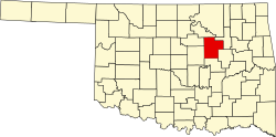
Creek County Oklahoma incorporated and unincorporated areas Oakhurst highlighted.svg
Location within Creek County, and the state of Oklahoma
Coordinates: 36°4′45″N96°3′5″W / 36.07917°N 96.05139°W / 36.07917; -96.05139
Country United States
State Oklahoma
Counties Tulsa, Creek
Area
[1]
  Total5.54 sq mi (14.34 km2)
  Land5.54 sq mi (14.34 km2)
  Water0.00 sq mi (0.01 km2)
Elevation
[2]
768 ft (234 m)
Population
 (2020)
  Total2,262
  Density408.60/sq mi (157.77/km2)
Time zone UTC-6 (Central (CST))
  Summer (DST) UTC-5 (CDT)
ZIP code
74050
Area code(s) 539/918
FIPS code 40-53350 [3]
GNIS feature ID1096147 [2]

Oakhurst is an unincorporated community and census-designated place (CDP) in Creek and Tulsa counties in the U.S. state of Oklahoma. The population was 2,262 at the 2020 census, [4] a slight increase from the 2010 population of 2,185.

Contents

Geography

Oakhurst is located in western Tulsa County and northeastern Creek County at 36°4′45″N96°3′5″W / 36.07917°N 96.05139°W / 36.07917; -96.05139 (36.079291, -96.051444). [5] It is bordered by Tulsa to the east, Sand Springs to the northwest, and Sapulpa to the south. Interstate 44 passes through the community, with access from exits 221 and 222. Downtown Tulsa is 7 miles (11 km) to the northeast via Interstate 244, which branches from I-44 in northeast Oakhurst.

According to the United States Census Bureau, the CDP has a total area of 5.7 square miles (14.7 km2), all land. [6] The CDP has lost area over time as the surrounding cities expand; in 2000 the area of Oakhurst was 6.7 square miles (17.4 km2).

History

Oakhurst was established in 1918. [7]

Demographics

Historical population
CensusPop.Note
2020 2,262
U.S. Decennial Census [8]

As of the census [3] of 2000, there were 2,731 people, 1,067 households, and 767 families residing in the CDP. The population density was 406.8 inhabitants per square mile (157.1/km2). There were 1,191 housing units at an average density of 177.4 per square mile (68.5/km2). The racial makeup of the CDP was 81.03% White, 1.28% African American, 10.00% Native American, 0.55% Asian, 0.07% Pacific Islander, 0.73% from other races, and 6.33% from two or more races. Hispanic or Latino of any race were 2.49% of the population.

There were 1,067 households, out of which 28.2% had children under the age of 18 living with them, 55.9% were married couples living together, 10.4% had a female householder with no husband present, and 28.1% were non-families. 24.7% of all households were made up of individuals, and 9.0% had someone living alone who was 65 years of age or older. The average household size was 2.56 and the average family size was 3.04.

In the CDP, the population was spread out, with 24.6% under the age of 18, 7.8% from 18 to 24, 28.2% from 25 to 44, 26.4% from 45 to 64, and 12.9% who were 65 years of age or older. The median age was 38 years. For every 100 females, there were 97.8 males. For every 100 females age 18 and over, there were 97.5 males.

The median income for a household in the CDP was $34,858, and the median income for a family was $41,104. Males had a median income of $30,227 versus $20,453 for females. The per capita income for the CDP was $15,125. About 6.7% of families and 8.9% of the population were below the poverty line, including 3.9% of those under age 18 and 4.6% of those age 65 or over.

Related Research Articles

<span class="mw-page-title-main">Creek County, Oklahoma</span> County in Oklahoma, United States

Creek County is a county located in the U.S. state of Oklahoma. As of the 2020 census, the population was 71,754. Its county seat is Sapulpa.

<span class="mw-page-title-main">Farm Loop, Alaska</span> CDP in Alaska, United States

Farm Loop is a census-designated place (CDP) in Matanuska-Susitna Borough, Alaska, United States. It is part of the Anchorage, Alaska Metropolitan Statistical Area. At the 2020 census the population was 2,747, up from 1,028 in 2010.

<span class="mw-page-title-main">Burnt Store Marina, Florida</span> Census-designated place in Florida, United States

Burnt Store Marina is an unincorporated community and census-designated place (CDP) in Lee County, Florida, United States. The population was 1,890 at the 2020 census, up from 1,793 at the 2010 census. It is part of the Cape Coral-Fort Myers, Florida Metropolitan Statistical Area.

<span class="mw-page-title-main">Herald Harbor, Maryland</span> Census-designated place in Maryland, United States

Herald Harbor is a census-designated place and an unincorporated community in Anne Arundel County, Maryland, United States. As of the 2010 census, the population was 2,603. It is a quiet residential area with a scenic view of the Severn River and is near the community of Crownsville and Interstate 97. Herald Harbor is known for its area immediately along the Severn River known as Long Point on the Severn, a fairly affluent neighborhood composed mainly of retired and wealthy land owners.

<span class="mw-page-title-main">Oakhurst, New Jersey</span> Place in Monmouth County, New Jersey, United States

Oakhurst is an unincorporated community and census-designated place (CDP) within Ocean Township, in Monmouth County, in the U.S. state of New Jersey. As of the 2010 United States Census, the CDP's population was 3,995.

<span class="mw-page-title-main">Greasy, Oklahoma</span> Census-designated place in Oklahoma, United States

Greasy is a census-designated place (CDP) in Adair County, Oklahoma, United States. The population was 372 at the 2010 census.

<span class="mw-page-title-main">Marietta, Adair County, Oklahoma</span> Census-designated place in Oklahoma, United States

Marietta is a census-designated place (CDP) in Adair County, Oklahoma, United States. The population was 106 at the 2010 census. The community was listed as Maryetta at the 2000 census, at which time it had a population of 138.

<span class="mw-page-title-main">Peavine, Oklahoma</span> Census-designated place in Oklahoma, United States

Peavine is a census-designated place (CDP) in Adair County, Oklahoma, United States. The population was 423 at the 2010 census.

<span class="mw-page-title-main">Tenkiller, Oklahoma</span> Census-designated place in Oklahoma, United States

Tenkiller is an unincorporated community and census-designated place (CDP) in Cherokee County, Oklahoma, United States. The population was 633 at the 2010 census.

<span class="mw-page-title-main">Welling, Oklahoma</span> Census-designated place in Oklahoma, United States

Welling is an unincorporated community and census-designated place (CDP) in Cherokee County, Oklahoma, United States. The population was 771 at the 2010 census, an increase of 15.25 percent over the figure of 669 recorded in 2000. It is home to The Salvation Army's Heart o' Hills camp and conference center.

Sycamore is a census-designated place (CDP) in Delaware County, Oklahoma, United States. The population was 177 at the 2010 census.

<span class="mw-page-title-main">Brushy, Oklahoma</span> CDP in Oklahoma, United States

Brushy is a census-designated place (CDP) in Sequoyah County, Oklahoma, United States, along U.S. Route 59 in the foothills of the Brushy Mountains. It is part of the Fort Smith, Arkansas-Oklahoma Metropolitan Statistical Area. The population was 900 at the 2010 census, an increase of 14.4 percent over the figure of 787 recorded in 2000.

<span class="mw-page-title-main">McKey, Oklahoma</span> CDP in Oklahoma, United States

McKey is a census-designated place (CDP) in Sequoyah County, Oklahoma, United States. It is part of the Fort Smith, Arkansas-Oklahoma Metropolitan Statistical Area. The population was 135 at the 2000 census. McKey was established on the Old Osage and Arkansas Valley Railroad near MacKey's Salt Works. The post office existed from March 13, 1891, until July 14, 1928.

<span class="mw-page-title-main">Notchietown, Oklahoma</span> CDP in Oklahoma, United States

Notchietown is a census-designated place (CDP) in Sequoyah County, Oklahoma, United States. It is part of the Fort Smith, Arkansas-Oklahoma Metropolitan Statistical Area. The population was 430 at the 2000 census.

Pinhook Corners is a census-designated place (CDP) in Sequoyah County, Oklahoma, United States. It is part of the Fort Smith, Arkansas-Oklahoma Metropolitan Statistical Area. The population was 161 at the 2000 census.

Short is a census-designated place (CDP) in Sequoyah County, Oklahoma, United States. It is part of the Fort Smith, Arkansas-Oklahoma Metropolitan Statistical Area. The population was 328 at the 2000 census.

Sycamore is a census-designated place (CDP) in Sequoyah County, Oklahoma, United States. It is part of the Fort Smith, Arkansas-Oklahoma Metropolitan Statistical Area. The population was 150 at the 2000 census.

Lotsee is a town in Tulsa County, Oklahoma, United States. The population was 6 at the 2020 census, compared to a total of 2 in 2010. It is the smallest incorporated municipality in Oklahoma.

<span class="mw-page-title-main">Turley, Oklahoma</span> CDP in Oklahoma, United States

Turley is a census-designated place (CDP) in Tulsa County, Oklahoma, United States. The population was 2,607 at the time of the 2020 census.

Lake Tansi Village is a resort community in Cumberland County, Tennessee, United States, recognized by the U.S. Census as a census-designated place (CDP). The population was 5,629 at the 2020 census.

References

  1. "ArcGIS REST Services Directory". United States Census Bureau. Retrieved September 20, 2022.
  2. 1 2 U.S. Geological Survey Geographic Names Information System: Oakhurst, Oklahoma
  3. 1 2 "U.S. Census website". United States Census Bureau . Retrieved January 31, 2008.
  4. "Oakhurst (CDP), Oklahoma". United States Census Bureau. Retrieved August 13, 2023.
  5. "US Gazetteer files: 2010, 2000, and 1990". United States Census Bureau. February 12, 2011. Retrieved April 23, 2011.
  6. "Geographic Identifiers: 2010 Demographic Profile Data (G001): Oakhurst CDP, Oklahoma". U.S. Census Bureau, American Factfinder. Archived from the original on March 9, 2015. Retrieved March 9, 2015.
  7. "Tulsa County Historic Sites :: TULSA AND OKLAHOMA HISTORY COLLECTION". cdm15020.contentdm.oclc.org. Retrieved December 11, 2019.
  8. "Census of Population and Housing". Census.gov. Retrieved June 4, 2016.