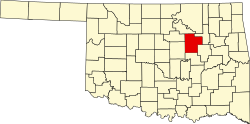
Oilton, Oklahoma

Last updated

Oilton, Oklahoma
Creek County Oklahoma incorporated and unincorporated areas Oilton highlighted.svg
Location within Creek County, and the state of Oklahoma
Coordinates: 36°04′58″N96°34′53″W / 36.08278°N 96.58139°W / 36.08278; -96.58139
Country United States
State Oklahoma
County Creek
Area
[1]
  Total1.13 sq mi (2.93 km2)
  Land1.13 sq mi (2.93 km2)
  Water0.00 sq mi (0.00 km2)
Elevation
[2]
794 ft (242 m)
Population
 (2020)
  Total885
  Density783.19/sq mi (302.32/km2)
Time zone UTC-6 (Central (CST))
  Summer (DST) UTC-5 (CDT)
ZIP code
74052
Area code(s) 539/918
FIPS code 40-54000 [3]
GNIS feature ID2411307 [2]
Website www.cityofoilton.com

Oilton is a city in Creek County, Oklahoma, United States. The population was 885 at the 2020 census, a 12.6% decline from the 1,013 recorded in 2010. [4]

Contents

History

Oilton began during the development of the Cushing-Drumright Oil Field. The first lots were sold in January and February 1915 by Walter Eaton and Ed Dunn. A post office was established May 5, 1915. The First State Bank opened and the newspaper, the Oilton Gusher, began publication in 1915. In the same year, the Oil Belt Terminal Railway connected Oilton to Jennings, while the Oil Fields and Santa Fe Railway, an Atchison, Topeka and Santa Fe Railway subsidiary, bought the Oil Belt and additionally connected the town to Cushing and Drumright. [5] By 1920, Oilton's population officially peaked at 2,231. It became an incorporated city on April 18, 1921. [6] Despite a rapid drop in petroleum production in the Cushing-Drumright field throughout the 1920s and 1930s, Oilton survived when a number of other oilboom towns did not. [7]

Oilton, Oklahoma Oil..jpg
Oilton, Oklahoma

Geography

Oilton is located in northwestern Creek County. It is on the south side of the Cimarron River near the head of the inundation limit of Keystone Lake.

Oklahoma State Highway 99 passes through the community, leading north 7 miles (11 km) to Jennings and south 7 miles (11 km) to Drumright. Tulsa is 38 miles (61 km) to the east, and Stillwater is 30 miles (48 km) to the west.

According to the United States Census Bureau, Oilton has a total area of 1.0 square mile (2.7 km2), all land. [8]

Demographics

Historical population
CensusPop.Note
1920 2,231
1930 1,518−32.0%
1940 1,225−19.3%
1950 1,109−9.5%
1960 1,100−0.8%
1970 1,087−1.2%
1980 1,24414.4%
1990 1,060−14.8%
2000 1,0993.7%
2010 1,013−7.8%
2020 885−12.6%
U.S. Decennial Census [9]

As of the census [3] of 2000, there were 1,099 people, 447 households, and 291 families residing in the city. The population density was 1,690.2 inhabitants per square mile (652.6/km2). There were 526 housing units at an average density of 809.0 per square mile (312.4/km2). The racial makeup of the city was 86.72% White, 0.82% African American, 6.64% Native American, 0.73% from other races, and 5.10% from two or more races. Hispanic or Latino of any race were 2.73% of the population.

There were 447 households, out of which 33.6% had children under the age of 18 living with them, 51.2% were married couples living together, 10.3% had a female householder with no husband present, and 34.7% were non-families. 30.9% of all households were made up of individuals, and 16.3% had someone living alone who was 65 years of age or older. The average household size was 2.46 and the average family size was 3.11.

In the city, the population was spread out, with 29.1% under the age of 18, 9.2% from 18 to 24, 26.7% from 25 to 44, 20.0% from 45 to 64, and 15.0% who were 65 years of age or older. The median age was 34 years. For every 100 females, there were 89.2 males. For every 100 females age 18 and over, there were 87.3 males.

The median income for a household in the city was $23,274, and the median income for a family was $29,766. Males had a median income of $26,250 versus $19,219 for females. The per capita income for the city was $11,831. About 21.7% of families and 26.4% of the population were below the poverty line, including 35.7% of those under age 18 and 12.7% of those age 65 or over.

Economy

Oil production has steadily declined. The local economy is largely agricultural. About 91 percent of the employed Oilton residents commute to jobs in Bristow, Sapulpa and Sand Springs. [6]

Related Research Articles

<span class="mw-page-title-main">Payne County, Oklahoma</span> County in Oklahoma, United States

Payne County is located in the U.S. state of Oklahoma. As of the 2020 census, its population was 81,646. Its county seat is Stillwater. The county was created in 1890 as part of Oklahoma Territory and is named for Capt. David L. Payne, a leader of the "Boomers".

<span class="mw-page-title-main">Creek County, Oklahoma</span> County in Oklahoma, United States

Creek County is a county located in the U.S. state of Oklahoma. As of the 2020 census, the population was 71,754. Its county seat is Sapulpa.

<span class="mw-page-title-main">Carter County, Oklahoma</span> County in Oklahoma, United States

Carter County is a county in the U.S. state of Oklahoma. As of the 2020 census, the population was 48,003. Its county seat is Ardmore. The county was named for Captain Ben W. Carter, a Cherokee who lived among the Chickasaw.

<span class="mw-page-title-main">Vernon, Illinois</span> Village in Illinois, United States

Vernon is a village in Marion County, Illinois, United States. The population was 103 at the 2020 census.

<span class="mw-page-title-main">Wilson, Oklahoma</span> Town in Oklahoma, United States

Wilson is a town in Carter County, Oklahoma, United States. The population was 1,724 at the 2010 census. It is part of the Ardmore, Oklahoma Micropolitan Statistical Area. It is home to one of the oldest Assemblies of God churches in Oklahoma, the Wilson Assembly of God Church.

<span class="mw-page-title-main">Shamrock, Oklahoma</span> Town in Oklahoma, United States

Shamrock is an unincorporated community in Creek County, Oklahoma, United States, located on Oklahoma State Highway 16 south of Drumright and west-northwest of Bristow. The population was 65 at the time of the 2020 census. It was named for Shamrock, Illinois, the hometown of local store owner, James M. Thomas.

<span class="mw-page-title-main">Braman, Oklahoma</span> Town in Oklahoma, United States

Braman is a town in Kay County, Oklahoma, United States. The population was 217 at the 2010 census, a decline of 11.1 percent from the figure of 244 in 2000.

<span class="mw-page-title-main">Tonkawa, Oklahoma</span> City in Oklahoma, United States

Tonkawa is a city in Kay County, Oklahoma, United States, along the Salt Fork Arkansas River. The population was 3,216 at the 2010 census, a decline of 2.5 percent from the figure of 3,299 in 2000.

<span class="mw-page-title-main">Coyle, Oklahoma</span> Town in Oklahoma, United States

Coyle is a town in Logan County, Oklahoma, United States. The population was 325 at the 2010 census, compared to the figure of 337 in 2000. It is part of the Oklahoma City metropolitan area. The town was named for William Coyle, an influential Guthrie business man.

<span class="mw-page-title-main">Marietta, Oklahoma</span> City in Oklahoma, United States.

Marietta is a city and county seat in Love County, Oklahoma, United States. The population was 2,626 at the 2010 census, a 7.4 percent increase from the figure of 2,445 in 2000. Marietta is part of the Ardmore, Oklahoma, Micropolitan Statistical Area. For tourism purposes, the Oklahoma Department of Tourism includes it in 'Chickasaw Country'. It is also a part of the Texoma region.

<span class="mw-page-title-main">Marland, Oklahoma</span> Town in Oklahoma, United States

Marland is a town in Noble County, Oklahoma, United States. The population was 225 at the 2010 census. It was named for Ernest W. Marland, an oilman from nearby Ponca City who later became a governor of Oklahoma. Marland is on SH-156, south-southwest of Ponca City.

<span class="mw-page-title-main">Fairfax, Oklahoma</span> Town in Oklahoma, United States

Fairfax is a town in Osage County, Oklahoma, United States. The Osage Nation reservation is coterminous with the county. The population was 1,380 at the 2010 census, down 11.3 percent from the figure of 1,555 recorded in 2000. It is notable as the home of world-famous ballerinas Maria and Marjorie Tallchief.

<span class="mw-page-title-main">Webb City, Oklahoma</span> Town in Oklahoma, United States

Webb City is an unincorporated town in northwestern Osage County, Oklahoma, United States. The population was 62 at the 2010 census, a 34.7 percent decline from the figure of 95 recorded in 2000. It was named for its founder, Horace Webb, on whose land the town was founded. The Webb City post office opened December 16, 1922.

<span class="mw-page-title-main">Cushing, Oklahoma</span> City in Oklahoma, United States

Cushing is a city in Payne County, Oklahoma, United States. The population was 7,826 at the time of the 2010 census, a decline of 6.5% since 8,371 in 2000. Cushing was established after the Land Run of 1891 by William "Billy Rae" Little. It was named for Marshall Cushing, private secretary to U.S. Postmaster General John Wanamaker.

<span class="mw-page-title-main">Ripley, Oklahoma</span> Town in Oklahoma, United States

Ripley is a town in southeastern Payne County, Oklahoma, United States. The population was 423 at the 2010 census, a decline of 9.2 percent from the figure of 444 in 2000. The town was named after Edward Ripley, the 14th president of the Atchison, Topeka and Santa Fe Railway.

<span class="mw-page-title-main">Yale, Oklahoma</span> City in Oklahoma, United States

Yale is a city in Payne County, Oklahoma, United States. The population was 1,059 at the 2020 census, a decline of 13.6 percent from the figure of 1,227 in 2010.

<span class="mw-page-title-main">Wanette, Oklahoma</span> Town in Oklahoma, United States

Wanette is a town in Pottawatomie County, Oklahoma, United States. The population was 350 at the 2010 census, a decline of 13 percent from the figure of 402 in 2000. Wanette is part of the Purcell-Lexington retail trade area and is within the Greater Oklahoma City Metropolitan Area.

<span class="mw-page-title-main">Drumright, Oklahoma</span> City in Oklahoma, United States

Drumright is a city in Creek and Payne counties in the U.S. state of Oklahoma. It began as an oil boom town. However, the population has declined as oil production has waned in the area. The population was 2,907 at the 2010 census, a figure almost unchanged from 2,905 in 2000. Drumright and nearby Cushing were at the center of the large, productive Cushing-Drumright Oil Field in the 1910s and 1920s. Now Drumright is home to a festival called The Drumright Monthly Market, where hundreds of visitors come, seeking crafts and delicacies from all over the region. First Saturday of every month.

<span class="mw-page-title-main">Cashion, Oklahoma</span> Town in Oklahoma, United States

Cashion is a town in Kingfisher and Logan counties in the U.S. state of Oklahoma. The Logan County portion of Cashion is part of the Oklahoma City Metropolitan Statistical Area. The town population was 802 at the 2010 census, up from 643 in 2000.

The Oil Fields and Santa Fe Railway was an Atchison, Topeka and Santa Fe Railway ("AT&SF") subsidiary. It owned trackage in and about the Cushing-Drumright Oil Field in Oklahoma, and was leased to and operated by the AT&SF from its inception in the 1915-1916 timeframe until its merger into the AT&SF in 1941. All of its tracks were abandoned by 1963.

References

  1. "ArcGIS REST Services Directory". United States Census Bureau. Retrieved September 20, 2022.
  2. 1 2 U.S. Geological Survey Geographic Names Information System: Oilton, Oklahoma
  3. 1 2 "U.S. Census website". United States Census Bureau . Retrieved January 31, 2008.
  4. "Oilton (city), Oklahoma". U.S. Census Bureau. Retrieved April 3, 2023.
  5. "Oil Fields and Santa Fe Railway Company, Cushing Traction Company, and Oil Belt Terminal Railway Company". Railroads of Oklahoma, June 6, 1870-April 1, 1978, pp. 35-39 (accessed of Oklahoma Digital Prairie). Retrieved July 26, 2022.
  6. 1 2 Wilson, Linda D. "Oilton," Encyclopedia of Oklahoma History and Culture. Accessed July 13, 2015.
  7. "Cushing-Drumright Field". Bobby D. Weaver, Oklahoma Historical Society. Retrieved April 3, 2023.
  8. "Geographic Identifiers: 2010 Demographic Profile Data (G001): Oilton city, Oklahoma". U.S. Census Bureau, American Factfinder. Archived from the original on March 9, 2015. Retrieved March 6, 2015.
  9. "Census of Population and Housing". Census.gov. Retrieved June 4, 2015.