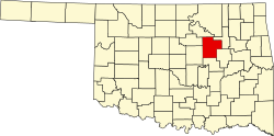
Olive, Oklahoma

Last updated

Olive, Oklahoma
USA Oklahoma location map.svg
Red pog.svg
Olive
Location within the state of Oklahoma
Usa edcp location map.svg
Red pog.svg
Olive
Olive (the United States)
Coordinates: 36°01′21″N96°28′36″W / 36.02250°N 96.47667°W / 36.02250; -96.47667
Country United States
State Oklahoma
County Creek
Area
[1]
  Total1.31 sq mi (3.39 km2)
  Land1.31 sq mi (3.39 km2)
  Water0.00 sq mi (0.01 km2)
Elevation
[2]
902 ft (275 m)
Population
 (2020)
  Total110
  Density84.16/sq mi (32.49/km2)
Time zone UTC-6 (Central (CST))
  Summer (DST) UTC-5 (CDT)
FIPS code 40-55350
GNIS feature ID2805346 [2]

Olive is an unincorporated community in Creek County, Oklahoma, United States. The post office was established November 20, 1896, and discontinued September 30, 1938.[ citation needed ] The town was named for the daughter of the first postmaster.[ citation needed ] In 1974 there was a tornado that wiped out the town.[ citation needed ] Today, it is a small community with 42 homes or roughly 126 people.[ citation needed ] There are three churches, a convenience store called "Happy Corner," and a small school of 465 students Pre-K through 12.[ citation needed ] Olive was the birthplace of Leon "Jack" Guthrie.[ citation needed ]

Related Research Articles

<span class="mw-page-title-main">Jet, Oklahoma</span> Town in Oklahoma, United States

Jet is a town in southeast Alfalfa County, Oklahoma, United States. The population was 213 at the 2010 census.

<span class="mw-page-title-main">Lambert, Oklahoma</span> Town in Oklahoma, United States

Lambert is a town in Alfalfa County, Oklahoma, United States. The population was six at the 2010 census.

<span class="mw-page-title-main">Durant, Oklahoma</span> City in Oklahoma, United States

Durant is a city in Bryan County, Oklahoma, United States that serves as the headquarters of the Choctaw Nation of Oklahoma. The population was 18,589 in the 2020 census. Durant is the principal city of the Durant Micropolitan Statistical Area, which had a population of 46,067 in 2020. The city is the largest in the Choctaw Nation, ranking ahead of McAlester and Poteau. Durant is also part of the Dallas–Fort Worth Combined Statistical Area, anchoring the northern edge.

<span class="mw-page-title-main">Calumet, Oklahoma</span> Town in Oklahoma, United States

Calumet is a town in Canadian County, Oklahoma, United States. It is part of the Oklahoma City Metropolitan Area. The population was 507 at the 2010 census, a 5.23 percent decrease since 2000.

<span class="mw-page-title-main">El Reno, Oklahoma</span> City in Oklahoma, United States

El Reno is a city in and county seat of Canadian County, Oklahoma, United States. As of the 2020 census, the city population was 16,989, marking a change of 1.55% from 16,729, recorded in the 2010 census. The city was begun shortly after the 1889 land rush and named for the nearby Fort Reno. It is located in Central Oklahoma, about 25 miles (40 km) west of downtown Oklahoma City.

<span class="mw-page-title-main">Soper, Oklahoma</span> Town in Oklahoma, United States

Soper is a town in Choctaw County, Oklahoma, United States. The population was 261 at the 2010 census. The town was named for Pliny L. Soper, who was an attorney for the Arkansas and Choctaw Railway.

<span class="mw-page-title-main">Depew, Oklahoma</span> Town in Oklahoma, United States

Depew is a town in Creek County, Oklahoma, United States. It is 41 miles southwest of Tulsa. The population was 411 at the 2020 census. The town was named in honor of New York Senator Chauncey Depew.

<span class="mw-page-title-main">Holdenville, Oklahoma</span> City in Oklahoma, United States

Holdenville is a city in and county seat of Hughes County, Oklahoma, United States. The population was 5,771 at the 2010 census, an increase of 22 percent from 4,732 at the 2000 census.

<span class="mw-page-title-main">Kingfisher, Oklahoma</span> City in Oklahoma, United States

Kingfisher is a city in and the county seat of Kingfisher County, Oklahoma,. The population was 4,903 at the time of the 2020 census. It is the former home and namesake of Kingfisher College. According to the Encyclopedia of Oklahoma History and Culture, Kingfisher is now primarily a bedroom community for people employed in Enid and Oklahoma City.

<span class="mw-page-title-main">Kingston, Oklahoma</span> Town in Oklahoma, United States

Kingston is a town in Marshall County, Oklahoma, United States, in the central southern portion of the state close to the border. The population was 1,601 at the 2010 census.

<span class="mw-page-title-main">Locust Grove, Oklahoma</span> Town in Oklahoma, United States

Locust Grove is a town in Mayes County, Oklahoma, United States. The population was 1,423 at the 2010 census, a 4.2 percent increase over the figure of 1,366 recorded in 2000.

<span class="mw-page-title-main">Eufaula, Oklahoma</span> City in Oklahoma, United States

Eufaula is a city and county seat of McIntosh County, Oklahoma, United States. The population was 2,813 at the 2010 census, an increase of 6.6 percent from 2,639 in 2000. Eufaula is in the southern part of the county, 30 miles (48 km) north of McAlester and 32 miles (51 km) south of Muskogee.

Asher is a town in Pottawatomie County, Oklahoma. The population was 393 at the 2010 census, a decline of 6.2 percent from the figure of 419 in 2000.

<span class="mw-page-title-main">Wagoner, Oklahoma</span> City in Oklahoma, United States

Wagoner is a city in Wagoner County, Oklahoma, United States. The population was 8,323 at the 2010 census, compared to the figure of 7,669 recorded in 2000. It is the county seat of Wagoner County. Wagoner became the first city incorporated in Indian Territory on January 4, 1896.

<span class="mw-page-title-main">Red River of the South</span> Major river in the southern United States

The Red River, or sometimes the Red River of the South, is a major river in the Southern United States. It was named for its reddish water color from passing through red-bed country in its watershed. It is known as the Red River of the South to distinguish it from the Red River of the North, which flows between Minnesota and North Dakota into the Canadian province of Manitoba. Although once a tributary of the Mississippi River, the Red River is now a tributary of the Atchafalaya River, a distributary of the Mississippi that flows separately into the Gulf of Mexico. This confluence is connected to the Mississippi River by the Old River Control Structure.

<span class="mw-page-title-main">Bunch, Oklahoma</span> Unincorporated community and Census designated place in Oklahoma, United States

Bunch is an unincorporated community and Census designated place in southwestern Adair County, Oklahoma, United States. It was named after a Cherokee vice-chief named Rabbit Bunch who lived in the area in the 1880s. Nestled in the Sallisaw Creek valley, Bunch is bisected by the Kansas City Southern Railroad, which was built in the 1890s. Bunch is in the Cookson Hills area of eastern Oklahoma which are a part of the western area of the Ozark Mountains. The Cookson Hills Wildlife Management Area is west of the town. Two and one-half miles north of town is Cave Springs Public Schools, a K-12 school which serves Bunch and the surrounding area.

Preston is an unincorporated community located in Okmulgee County, Oklahoma, United States. The post office was established December 13, 1909. It was named for an Okmulgee oilman, Harry Preston.

Olive is an unincorporated parcel of about 32.67 acres (132,200 m2) in the city of Orange, located along Lincoln Avenue, between Eisenhower Park and Orange Olive Road.

Albert is an unincorporated place in Caddo County, Oklahoma, United States. It is located approximately six miles southwest of Binger on State Highway 146.

Welty is an unincorporated community in Okfuskee County, Oklahoma, United States. Named for the town developer, Edwin A. Welty, its post office was established October 12, 1905, with Jerimiah D. Wilson as the first postmaster.

References

  1. "ArcGIS REST Services Directory". United States Census Bureau. Retrieved September 20, 2022.
  2. 1 2 U.S. Geological Survey Geographic Names Information System: Olive, Oklahoma