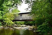
Mill Covered Bridge (Belvidere, Vermont)

Last updated
Mill Covered Bridge
MillBridge.JPG
Bridge in U.S. state of Vermont
Coordinates 44°44′38″N72°44′27″W / 44.7439°N 72.7408°W / 44.7439; -72.7408
CarriesAutomobile
CrossesNorth Branch of Lamoille River
Locale Belvidere, Vermont
Maintained byTown of Belvidere
ID number VT-08-06
Characteristics
DesignCovered, Town lattice
MaterialWood
Total length70 ft 4.75 in (21.46 m)
Width11 ft 11.5 in (3.64 m)
No. of spans1
Load limit8 tons
History
Constructed byLewis Robinson
Construction end1895
USA Vermont location map.svg
Red pog.svg
Usa edcp location map.svg
Red pog.svg
Coordinates 44°44′38″N72°44′27″W / 44.74389°N 72.74083°W / 44.74389; -72.74083 Coordinates: 44°44′38″N72°44′27″W / 44.74389°N 72.74083°W / 44.74389; -72.74083
Area1 acre (0.40 ha)
NRHP reference No. 74000227 [1]
Added to NRHPNovember 19, 1974

The Mill Covered Bridge is a wooden covered bridge that crosses the North Branch Lamoille River on Back Road in Belvidere, Vermont. Built about 1890, it is one of two surviving covered bridges in the rural community. It was listed on the National Register of Historic Places in 1974. [1]

Contents

Description and history

The Mill Covered Bridge stands in a rural area west of the village center of Belvidere, carrying Back Road (which runs west from the town north of the river) to its junction with Vermont Route 109 (which runs west from the town south of the river). The bridge is a single-span Queen post truss structure, 70 feet (21 m) long and 15 feet (4.6 m) wide, with a roadway width of 12 feet (3.7 m) (one lane). Its trusses are set on abutments of dry laid stone that have been capped in concrete. They are set slightly skewed, giving the bridge a parallelogram shape. The exterior of the bridge is finished in vertical board siding, which extends around to the insides of the portals. The siding ends short of the roof on the sides, leaving an open strip. The north portal opening is framed as a segmented-arch opening, while that on the south end is rectangular with diagonal corners. The bridge deck is wooden planking laid in steel I-beams, which now carry the bridge's active load. [2]

The bridge was built by Lewis Robinson in about 1890. It is one of two bridges in Belvidere (the other, the Morgan Covered Bridge, is east of this one), and one of five bridges across the North Branch Lamoille in a span of five miles. [2] The steel beams were installed under the deck of the bridge in 1971 after a contractor's snowplow broke through. The trusses were repaired in 1995 by Jan Lewandoski and Paul Ide. [3]

Belvederemill.jpg

See also

Related Research Articles

<span class="mw-page-title-main">Gold Brook Covered Bridge</span> United States historic place

Gold Brook Covered Bridge, also known as Stowe Hollow Bridge or Emily's Bridge, is a small wooden covered bridge in the town of Stowe, Lamoille County, Vermont, carrying Covered Bridge Road over Gold Brook. Built in 1844, it is the only 19th-century covered bridge in the state built using wooden Howe trusses and carrying a public roadway. It was added to the National Register of Historic Places in 1974.

<span class="mw-page-title-main">Church Street Covered Bridge</span> Bridge in Waterville, Vermont

The Church Street Covered Bridge, also called the Village Covered Bridge, is a wooden covered bridge that crosses the North Branch of the Lamoille River in Waterville, Vermont off State Route 109. Built in the late 19th century, it is one of five covered bridges in a space of about five miles that cross the North Branch Lamoille. It was listed on the National Register of Historic Places in 1974.

<span class="mw-page-title-main">Grist Mill Covered Bridge</span> Bridge in Cambridge, Vermont

The Grist Mill Covered Bridge, also known as the Scott Covered Bridge, the Bryant Covered Bridge, and the Canyon Covered Bridge, is a covered bridge that carries Canyon Road across the Brewster River, off Vermont Route 108 in Cambridge, Vermont. Built in the 19th century, it is one of a small number of surviving Burr arch truss bridges in the state, and is one of three left in Cambridge. It was listed on the National Register of Historic Places in 1974.

<span class="mw-page-title-main">Power House Covered Bridge</span> Bridge in Johnson, Vermont

The Power House Covered Bridge, also known as the School Street Covered Bridge, is a covered bridge from 1872 that crosses the Gihon River off State Route 100C in Johnson, Vermont, US. It was listed on the National Register of Historic Places in 1974. The bridge's name is from a now obsolete hydroelectric generating station just upstream from it. The bridge is of Queen post truss design by an unknown builder.

<span class="mw-page-title-main">Scribner Covered Bridge</span> Bridge in Johnson, Vermont

The Scribner Covered Bridge, also known as the Mudgett Covered Bridge, is a covered bridge that carries Rocky Road across the Gihon River off State Route 100C in eastern Johnson, Vermont. It was listed on the National Register of Historic Places in 1974. It is one of a small number of Vermont's covered bridges that are the result of covering an existing open bridge.

<span class="mw-page-title-main">Braley Covered Bridge</span> Historic covered bridge in Vermont

The Braley Covered Bridge, also called the Johnson Covered Bridge and Upper Blaisdell Covered Bridge, is a wooden covered bridge that crosses the Second Branch of the White River in Randolph, Vermont on Braley Covered Bridge Road. It was listed on the National Register of Historic Places in 1974. The bridge was built in 1904 as an uncovered kingspost truss bridge, and was covered in 1909.

<span class="mw-page-title-main">Gifford Covered Bridge</span> Bridge in Randolph, Vermont

The Gifford Covered Bridge, also called the C.K. Smith Covered Bridge, is a wooden covered bridge that crosses the Second Branch of the White River in Randolph, Vermont on Hyde Road. It was listed on the National Register of Historic Places in 1974. It is one of two bridges in the state that was uncovered when first built, its trusses boxed for shelter.

<span class="mw-page-title-main">Slaughter House Covered Bridge</span> Bridge in Northfield, Vermont

The Slaughter HouseCovered Bridge is a wooden covered bridge that carries Slaughterhouse Road across the Dog River in Northfield, Vermont. The Queen post truss bridge is one of five surviving 19th-century bridges in the town. It was listed on the National Register of Historic Places in 1974.

<span class="mw-page-title-main">Lower Cox Brook Covered Bridge</span> Bridge in Northfield, Vermont

The Lower Cox Brook Covered Bridge is a wooden covered bridge that crosses Cox Brook in Northfield, Vermont on Cox Brook Road. Built in 1872, it is one of five surviving 19th-century covered bridges in the town, in the only place in Vermont where two historic bridges are visible from each other. It was listed on the National Register of Historic Places in 1974.

<span class="mw-page-title-main">Pine Brook Covered Bridge</span> Bridge in Waitsfield, Vermont

The Pine Brook Covered Bridge, also called the Wilder Covered Bridge, is a wooden covered bridge that crosses Pine Brook in Waitsfield, Vermont on North Road. Built in 1872, it is one two surviving 19th-century covered bridges in the town. It was listed on the National Register of Historic Places in 1974.

<span class="mw-page-title-main">Hutchins Covered Bridge</span> Bridge in Montgomery, Vermont

The Hutchins Covered Bridge is a wooden covered bridge that crosses the South Branch of the Trout River in Montgomery, Vermont on Hutchins Bridge Road. It was built in 1883 by Sheldon & Savannah Jewett, brothers who are credited with building most of the area's covered bridges. It was listed on the National Register of Historic Places in 1974.

<span class="mw-page-title-main">Morgan Covered Bridge</span> Bridge in Belvidere, Vermont

The Morgan Covered Bridge, also known as the Upper Covered Bridge is a wooden covered bridge that crosses the North Branch Lamoille River in Belvidere, Vermont on Morgan Bridge Road. Built about 1887, it is one of two covered bridges in Belvidere, and one of five in a five-mile span that all cross the same river. It was listed on the National Register of Historic Places in 1974.

<span class="mw-page-title-main">Montgomery Covered Bridge</span> Bridge in Waterville, Vermont

The Montgomery Covered Bridge, also known as the Lower Covered Bridge is a wooden covered bridge that carries Montgomery Road across the North Branch of the Lamoille River in Waterville, Vermont. Built in 1887, it is one of three covered bridges in the town, and one of five on the river in a five-mile span. It was listed on the National Register of Historic Places in 1974.

<span class="mw-page-title-main">Waterman Covered Bridge</span> United States historic place

The Waterman Covered Bridge was an historic covered bridge in Johnson, Vermont that carried Waterman Road across Waterman Creek. Built in 1868, it was one of three surviving 19th-century bridges in the town. It was listed on the National Register of Historic Places in 1974, and collapsed in January 1982.

<span class="mw-page-title-main">Fisher Covered Railroad Bridge</span> United States historic place

The Fisher Covered Railroad Bridge is a covered bridge in Wolcott, Vermont. Built in 1908, it originally carried the St. Johnsbury and Lamoille County Railroad line over the Lamoille River. Now closed, it was the last covered bridge in Vermont to carry railroad traffic, and is a rare surviving example in the state of a double Town lattice truss. It was listed on the National Register of Historic Places in 1974.

<span class="mw-page-title-main">Thetford Center Covered Bridge</span> United States historic place

The Thetford Center Covered Bridge is a historic covered bridge, carrying Tucker Hill Road across the Ompompanoosuc River in Thetford, Vermont. It is the state's only known example of the Haupt patent truss system. It was listed on the National Register of Historic Places in 1974.

<span class="mw-page-title-main">Bridge 6 (Johnson, Vermont)</span> United States historic place

The Railroad Street Bridge is a historic Pratt through truss bridge, carrying Railroad Street across the Lamoille River in Johnson, Vermont. It was built in 1928, after the state's devastating 1927 floods, and is one of its few surviving Pratt through truss bridges. It was listed on the National Register of Historic Places in 2007 as Bridge 6.

<span class="mw-page-title-main">Jaynes Covered Bridge</span> United States historic place

The Jaynes Covered Bridge is a historic covered bridge, carrying Codding Hollow Road across the North Branch Lamoille River in Waterville, Vermont. Built in 1877, it is one of three 19th-century covered bridges in the town, and one of five to span the North Branch Lamoille in a five-mile span. It was listed on the National Register of Historic Places in 1974.

<span class="mw-page-title-main">Jeffersonville Bridge</span> United States historic place

The Jeffersonville Bridge is a steel girder bridge carrying Vermont Route 108 across the Lamoille River, just north of the village of Jeffersonville, Vermont. It was built in 2014, replacing a Parker through truss bridge built in 1931; the latter bridge was listed on the National Register of Historic Places in 1991.

<span class="mw-page-title-main">Red Covered Bridge (Morristown, Vermont)</span> United States historic place

The Red Covered Bridge is a historic covered bridge, carrying Cole Hill Road across Sterling Brook in Morristown, Vermont. Built in 1896, it is the only surviving 19th-century covered bridge in the town, and one of the last to be built during the historic period of covered bridge construction in the state. It is of queen post truss design, and was listed on the National Register of Historic Places in 1974.

References

  1. 1 2 "National Register Information System". National Register of Historic Places . National Park Service. July 9, 2010.
  2. 1 2 Hugh Henry (1974). "NRHP nomination for Mill Covered Bridge". National Park Service . Retrieved 2016-12-18. with photos from 1974
  3. Evans, Benjamin and June. New England's Covered Bridges. University Press of New England, 2004. ISBN   1-58465-320-5.