Mineralnye Vody

Last updated • 2 min readFrom Wikipedia, The Free Encyclopedia
Mineralnye Vody
Минеральные Воды
Min-Vody panarama.jpg
Panoramic view of Mineralnye Vody
Coat of Arms of Mineralnye Vody (Stavropol kray)(2011).jpg
Location of Mineralnye Vody
Mineralnye Vody
Russia administrative location map.svg
Red pog.svg
Mineralnye Vody
Location of Mineralnye Vody
Outline Map of Stavropol Krai.svg
Red pog.svg
Mineralnye Vody
Mineralnye Vody (Stavropol Krai)
Coordinates: 44°13′N43°08′E / 44.217°N 43.133°E / 44.217; 43.133
Country Russia
Federal subject Stavropol Krai [1]
Founded1878 OOjs UI icon edit-ltr-progressive.svg
Town status since1922
Government
  HeadKonstantin Gamayunov
Area
[2]
  Total51.55 km2 (19.90 sq mi)
Elevation
300 m (1,000 ft)
Population
  Total76,728
  Rank 213th in 2010
  Density1,500/km2 (3,900/sq mi)
  Subordinated to town of krai significance of Mineralnye Vody [1]
   Capital oftown of krai significance of Mineralnye Vody, [1] Mineralovodsky District [1]
  Urban okrug Mineralovodsky Urban Okrug [4]
   Capital ofMineralovodsky Urban Okrug [4]
Time zone UTC+3 (MSK   OOjs UI icon edit-ltr-progressive.svg [5] )
Postal code(s) [6]
357200–357205, 357207, 357209, 357210–357212, 357260, 357261, 357265, 357270
Dialing code(s) +7 8792
OKTMO ID07721000001
Website web.archive.org/web/20120114070232/http://www.gorodminvody.ru/

Mineralnye Vody (Min-Vody) (Russian:Минеральные Воды (Мин-Воды),IPA: [mʲɪnʲɪˈralʲnɨjəˈvodɨ,mʲɪnˈvodɨ] ; lit. mineral waters) is a town in Stavropol Krai, Russia, located along the Kuma River and the main rail line between Rostov-on-Don in Russia and Baku in Azerbaijan. Population: 76,728(2010 Russian census); [3] 75,644(2002 Census); [7] 70,961(1989 Soviet census). [8]

Contents

History

The town owes its birth to the construction of the Rostov-Vladikavkaz Railway, which was completed in 1875. In 1878, the village which developed around the construction was officially recognized and named Sultanovsky. In 1906 the name was changed to Illarionovsky, in honor of Count I. I. Vorontsov-Dashkov, a local nobleman. In October 1921, at the end of the civil war when Soviet rule had been established, the name was again changed to Mineralnye Vody and town status was granted. [9] The new town had a population of around 14.000 people. It was occupied by Nazi Germany between 10 August 1942 and 11 January 1943 during World War II. During the German occupation, between 6500 and 7500 Jews were murdered in an anti-tank ditches located next to the city, [10] [11]

Administrative and municipal status

Within the framework of administrative divisions, Mineralnye Vody serves as the administrative center of Mineralovodsky District, even though it is not a part of it. [1] As an administrative division, it is incorporated separately as the town of krai significance of Mineralnye Vody—an administrative unit with the status equal to that of the districts. [1] As a municipal division, the territories of the town of krai significance of Mineralnye Vody and of Mineralovodsky District have been incorporated as Mineralovodsky Urban Okrug [4] since June 7, 2015. [12] Prior to that, the district was incorporated as Mineralovodsky Municipal District, with the town of krai significance of Mineralnye Vody being incorporated within it as Mineralnye Vody Urban Settlement. [12]

Economy

The town is served by the Mineralnye Vody Airport, connecting the town with some Russian and international destinations. It is connected by R217 highway (Russia) to Krasnodar and Derbent. The R217 forms part of European route E50.

Geography

The town is located along the Kuma River and the main rail line between Rostov-on-Don in Russia and Baku in Azerbaijan.

Climate

Mineralnye Vody's climate classified as humid continental (Köppen climate classification Dfa).

Climate data for Mineralnye Vody
MonthJanFebMarAprMayJunJulAugSepOctNovDecYear
Record high °C (°F)19.5
(67.1)
22.3
(72.1)
30.3
(86.5)
34.5
(94.1)
34.9
(94.8)
37.5
(99.5)
40.2
(104.4)
41.1
(106.0)
38.8
(101.8)
34.1
(93.4)
25.8
(78.4)
20.5
(68.9)
41.1
(106.0)
Mean daily maximum °C (°F)1.7
(35.1)
2.5
(36.5)
8.4
(47.1)
16.8
(62.2)
21.8
(71.2)
26.5
(79.7)
29.8
(85.6)
29.3
(84.7)
23.9
(75.0)
16.4
(61.5)
8.2
(46.8)
2.8
(37.0)
15.7
(60.3)
Daily mean °C (°F)−2.5
(27.5)
−2.4
(27.7)
2.9
(37.2)
10.1
(50.2)
15.1
(59.2)
19.6
(67.3)
22.7
(72.9)
22.0
(71.6)
16.8
(62.2)
10.2
(50.4)
3.4
(38.1)
−1.3
(29.7)
9.7
(49.5)
Mean daily minimum °C (°F)−5.7
(21.7)
−6.1
(21.0)
−1.2
(29.8)
4.6
(40.3)
9.2
(48.6)
13.6
(56.5)
16.2
(61.2)
15.7
(60.3)
11.2
(52.2)
5.8
(42.4)
0.2
(32.4)
−4.6
(23.7)
4.9
(40.8)
Record low °C (°F)−33.3
(−27.9)
−31.6
(−24.9)
−23.4
(−10.1)
−7.6
(18.3)
−2.9
(26.8)
3.2
(37.8)
7.4
(45.3)
4.2
(39.6)
−4.6
(23.7)
−18.0
(−0.4)
−23.6
(−10.5)
−31.5
(−24.7)
−33.3
(−27.9)
Average precipitation mm (inches)18
(0.7)
18
(0.7)
28
(1.1)
54
(2.1)
66
(2.6)
86
(3.4)
69
(2.7)
48
(1.9)
35
(1.4)
38
(1.5)
31
(1.2)
28
(1.1)
519
(20.4)
Source: Pogoda.ru.net [13]

Related Research Articles

<span class="mw-page-title-main">Zheleznovodsk</span> Town in Stavropol Krai, Russia

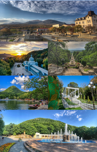
Zheleznovodsk is a town in Stavropol Krai, Russia. Population: 24,433 (2010 Russian census); 25,135 (2002 Census); 28,460 (1989 Soviet census).

<span class="mw-page-title-main">Andropovsky District</span> District in Stavropol Krai, Russia

Andropovsky District is an administrative district (raion), one of the twenty-six in Stavropol Krai, Russia. Municipally, it is incorporated as Andropovsky Municipal District. It is located in the southwest of the krai. The area of the district is 2,388 square kilometers (922 sq mi). Its administrative center is the rural locality of Kursavka. Population: 35,437 (2010 Russian census); 35,670 ; 32,216. The population of Kursavka accounts for 33.4% of the district's total population.

<span class="mw-page-title-main">Blagodarnensky District</span> District in Stavropol Krai, Russia

Blagodarnensky District is an administrative district (raion), one of the twenty-six in Stavropol Krai, Russia. Municipally, it is incorporated as Blagodarnensky Municipal District. It is located in the center of the krai. The area of the district is 2,471 square kilometers (954 sq mi). Its administrative center is the town of Blagodarny. Population: 62,047 (2010 Russian census); 66,172 ; 54,211. The population of Blagodarny accounts for 52.7% of the district's total population.

<span class="mw-page-title-main">Budyonnovsky District</span> District in Stavropol Krai, Russia

Budyonnovsky District is an administrative and municipal district (raion), one of the twenty-six in Stavropol Krai, Russia. It is located in the eastern central part of the krai. The area of the district is 3,203 square kilometers (1,237 sq mi). Its administrative center is the town of Budyonnovsk. Population: 53,251 (2010 Russian census); 54,085 ; 47,441.

<span class="mw-page-title-main">Ipatovsky District</span> District in Stavropol Krai, Russia

Ipatovsky District is an administrative district (raion), one of the twenty-six in Stavropol Krai, Russia. Municipally, it is incorporated as Ipatovsky Municipal District. It is located in the north of the krai. The area of the district is 4,036 square kilometers (1,558 sq mi). Its administrative center is the town of Ipatovo. Population: 62,751 (2010 Russian census); 69,268 ; 64,725. The population of Ipatovo accounts for 41.5% of the district's total population.

<span class="mw-page-title-main">Kirovsky District, Stavropol Krai</span> District in Stavropol Krai, Russia

Kirovsky District is an administrative district (raion), one of the twenty-six in Stavropol Krai, Russia. Municipally, it is incorporated as Kirovsky Municipal District. It is located in the south of the krai. The area of the district is 1,386 square kilometers (535 sq mi). Its administrative center is the town of Novopavlovsk. Population: 71,723 (2010 Russian census); 67,317 ; 55,074. The population of Novopavlovsk accounts for 37.0% of the district's total population.

<span class="mw-page-title-main">Kochubeyevsky District</span> District in Stavropol Krai, Russia

Kochubeyevsky District is an administrative district (raion), one of the twenty-six in Stavropol Krai, Russia. Municipally, it is incorporated as Kochubeyevsky Municipal District. It is located in the southwest of the krai. The area of the district is 2,363 square kilometers (912 sq mi). Its administrative center is the rural locality of Kochubeyevskoye. Population: 79,557 (2010 Russian census); 81,609 ; 69,512. The population of Kochubeyevskoye accounts for 33.7% of the district's total population.

<span class="mw-page-title-main">Krasnogvardeysky District, Stavropol Krai</span> District in Stavropol Krai, Russia

Krasnogvardeysky District is an administrative district (raion), one of the twenty-six in Stavropol Krai, Russia. Municipally, it is incorporated as Krasnogvardeysky Municipal District. It is located in the northwest of the krai. The area of the district is 2,236 square kilometers (863 sq mi). Its administrative center is the rural locality of Krasnogvardeyskoye. Population: 40,957 (2010 Russian census); 42,008 ; 39,855. The population of Krasnogvardeyskoye accounts for 39.1% of the district's total population.

<span class="mw-page-title-main">Kursky District, Stavropol Krai</span> District in Stavropol Krai, Russia

Kursky District is an administrative district (raion), one of the twenty-six in Stavropol Krai, Russia. Municipally, it is incorporated as Kursky Municipal District. It is located in the southeast of the krai. The area of the district is 3,694 square kilometers (1,426 sq mi). Its administrative center is the rural locality of Kurskaya. Population: 54,054 (2010 Russian census); 52,100 ; 43,303. The population of Kurskaya accounts for 22.3% of the district's total population.

<span class="mw-page-title-main">Levokumsky District</span> District in Stavropol Krai, Russia

Levokumsky District is an administrative district (raion), one of the twenty-six in Stavropol Krai, Russia. Municipally, it is incorporated as Levokumsky Municipal District. It is located in the northeast of the krai. The area of the district is 4,687 square kilometers (1,810 sq mi). Its administrative center is the rural locality of Levokumskoye. Population: 41,499 (2010 Russian census); 44,167 ; 42,369. The population of Levokumskoye accounts for 24.8% of the district's total population.

<span class="mw-page-title-main">Mineralovodsky District</span> District in Stavropol Krai, Russia

Mineralovodsky District is an administrative district (raion), one of the twenty-six in Stavropol Krai, Russia. It is located in the south of the krai. The area of the district is 1,490 square kilometers (580 sq mi). Its administrative center is the town of Mineralnye Vody. Population: 49,404 (2010 Russian census); 46,626 ; 38,669.

<span class="mw-page-title-main">Neftekumsky District</span> District in Stavropol Krai, Russia

Neftekumsky District is an administrative district (raion), one of the twenty-six in Stavropol Krai, Russia. Municipally, it is incorporated as Neftekumsky Municipal District. It is located in the east of the krai. The area of the district is 3,797 square kilometers (1,466 sq mi). Its administrative center is the town of Neftekumsk. Population: 68,778 (2010 Russian census); 70,902 ; 59,775. The population of Neftekumsk accounts for 40.3% of the district's total population.

<span class="mw-page-title-main">Novoalexandrovsky District</span> District in Stavropol Krai, Russia

Novoalexandrovsky District is an administrative district (raion), one of the twenty-six in Stavropol Krai, Russia. Municipally, it is incorporated as Novoalexandrovsky Municipal District. It is located in the west of the krai. The area of the district is 2,015 square kilometers (778 sq mi). Its administrative center is the town of Novoalexandrovsk. Population: 65,477 (2010 Russian census); 67,065 ; 58,630. The population of Novoalexandrovsk accounts for 40.9% of the district's total population.

<span class="mw-page-title-main">Novoselitsky District</span> District in Stavropol Krai, Russia

Novoselitsky District is an administrative district (raion), one of the twenty-six in Stavropol Krai, Russia. Municipally, it is incorporated as Novoselitsky Municipal District. It is located in the center of the krai. The area of the district is 1,724 square kilometers (666 sq mi). Its administrative center is the rural locality of Novoselitskoye. Population: 26,697 (2010 Russian census); 26,613 ; 23,021. The population of Novoselitskoye accounts for 32.7% of the district's total population.

<span class="mw-page-title-main">Petrovsky District, Stavropol Krai</span> District in Stavropol Krai, Russia

Petrovsky District is an administrative district (raion), one of the twenty-six in Stavropol Krai, Russia. Municipally, it is incorporated as Petrovsky Municipal District. It is located in the center of the krai. The area of the district is 2,741 square kilometers (1,058 sq mi). Its administrative center is the town of Svetlograd. Population: 78,067 (2010 Russian census); 82,449 ; 76,718. The population of Svetlograd accounts for 49.3% of the district's total population.

<span class="mw-page-title-main">Shpakovsky District</span> District in Stavropol Krai, Russia

Shpakovsky District is an administrative district (raion), one of the twenty-six in Stavropol Krai, Russia. Municipally, it is incorporated as Shpakovsky Municipal District. It is located in the west of the krai. The area of the district is 2,363 square kilometers (912 sq mi). Its administrative center is the town of Mikhaylovsk. Population: 123,071 (2010 Russian census); 108,717 ; 84,561. The population of Mikhaylovsk accounts for 57.7% of the district's total population.

<span class="mw-page-title-main">Sovetsky District, Stavropol Krai</span> District in Stavropol Krai, Russia

Sovetsky District is an administrative district (raion), one of the twenty-six in Stavropol Krai, Russia. Municipally, it is incorporated as Sovetsky Municipal District. It is located in the south of the krai. The area of the district is 2,089 square kilometers (807 sq mi). Its administrative center is the town of Zelenokumsk. Population: 62,790 (2010 Russian census); 72,762 ; 64,993. The population of Zelenokumsk accounts for 57.1% of the district's population.

<span class="mw-page-title-main">Trunovsky District</span> District in Stavropol Krai, Russia

Trunovsky District is an administrative district (raion), one of the twenty-six in Stavropol Krai, Russia. Municipally, it is incorporated as Trunovsky Municipal District. It is located in the northwest of the krai. The area of the district is 1,686 square kilometers (651 sq mi). Its administrative center is the rural locality of Donskoye. Population: 34,558 (2010 Russian census); 35,403 ; 32,093. The population of Donskoye accounts for 43.2% of the district's total population.

Andzhiyevsky is an urban locality under the administrative jurisdiction of the town of krai significance of Mineralnye Vody of Stavropol Krai, Russia. Population: 6,680 (2010 Russian census); 6,636 (2002 Census); 5,317 (1989 Soviet census).

<span class="mw-page-title-main">Divnoye, Stavropol Krai</span> Rural locality in Stavropol Krai, Russia

Divnoye is a rural locality and the administrative center of Apanasenkovsky District, Stavropol Krai, Russia. Population: 14,085 (2010 Russian census); 15,423 (2002 Census); 14,526 (1989 Soviet census).

References

Notes

  1. 1 2 3 4 5 6 7 Resolution #63-p
  2. Управление Росреестра по Ставропольскому краю. Доклад о состоянии и использовании земель Ставропольского края в 2010 году [ permanent dead link ], p. 54
  3. 1 2 Russian Federal State Statistics Service (2011). Всероссийская перепись населения 2010 года. Том 1 [2010 All-Russian Population Census, vol. 1]. Всероссийская перепись населения 2010 года [2010 All-Russia Population Census] (in Russian). Federal State Statistics Service.
  4. 1 2 3 Law #88-kz
  5. "Об исчислении времени". Официальный интернет-портал правовой информации (in Russian). June 3, 2011. Retrieved January 19, 2019.
  6. Почта России. Информационно-вычислительный центр ОАСУ РПО. (Russian Post). Поиск объектов почтовой связи (Postal Objects Search) (in Russian)
  7. Federal State Statistics Service (May 21, 2004). Численность населения России, субъектов Российской Федерации в составе федеральных округов, районов, городских поселений, сельских населённых пунктов – районных центров и сельских населённых пунктов с населением 3 тысячи и более человек [Population of Russia, Its Federal Districts, Federal Subjects, Districts, Urban Localities, Rural Localities—Administrative Centers, and Rural Localities with Population of Over 3,000](XLS). Всероссийская перепись населения 2002 года [All-Russia Population Census of 2002] (in Russian).
  8. Всесоюзная перепись населения 1989 г. Численность наличного населения союзных и автономных республик, автономных областей и округов, краёв, областей, районов, городских поселений и сёл-райцентров [All Union Population Census of 1989: Present Population of Union and Autonomous Republics, Autonomous Oblasts and Okrugs, Krais, Oblasts, Districts, Urban Settlements, and Villages Serving as District Administrative Centers]. Всесоюзная перепись населения 1989 года [All-Union Population Census of 1989] (in Russian). Институт демографии Национального исследовательского университета: Высшая школа экономики [Institute of Demography at the National Research University: Higher School of Economics]. 1989 via Demoscope Weekly.
  9. Great Russian Encyclopaedia (Moscow, 2004-2017), vol 20 (of 35), entry for Mineralnye Vody; ISBN   978-5-85270-354-5
  10. http://yahadmap.org/#village/mineralnye-vody-stavropol-russia.1160 [ bare URL ]
  11. https://collections.yadvashem.org/en/untold-stories/community/14621534-Mineralnyye-Vody [ bare URL ]
  12. 1 2 Law #51-kz
  13. "Pogoda.ru.net" (in Russian). Retrieved September 8, 2007.

Sources