Mishaum Point Military Reservation

Last updated
Mishaum Point Military Reservation
Part of Harbor Defenses of New Bedford
Dartmouth, Massachusetts
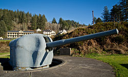
Coastal artillery gun at Fort Columbia State Park.jpg
6-inch gun at Fort Columbia State Park, Washington state, similar to Battery 210.
USA Massachusetts location map.svg
Red pog.svg
Mishaum Point Military Reservation
Location in Massachusetts
Coordinates 41°30′54.84″N70°57′13.94″W / 41.5152333°N 70.9538722°W / 41.5152333; -70.9538722
Type Coastal Defense
Site information
Ownerprivate
Open to
the public
no
Conditionbuilt on
Site history
Built1943-1945
Built byUnited States Army
In use1943–1947
Battles/wars World War II
Garrison information
Garrison Fort Rodman
A 155 mm gun on a Panama mount. 155mm GPF Garden Island WA 1943 AWM 054026.jpeg
A 155 mm gun on a Panama mount.

Mishaum Point Military Reservation was a coastal defense site located in Dartmouth, Massachusetts as part of the Harbor Defenses of New Bedford.

Contents

History

The Mishaum Point Military Reservation was built on land purchased in 1943. Its mission was to protect the Cape Cod Canal and New Bedford from possible air and naval attack. It never fired its guns in anger, but it did play an important part in the defense of the canal. The site also contained the Harbor Entrance Control Post for New Bedford harbor and a fire control tower. [1]

The reservation had a battery of two 6-inch M1 guns on long-range shielded carriages, with a large magazine and fire control bunker between them. The battery was called Battery 210. Additionally, the site initially had a pair of 155 mm towed guns on "Panama mounts", circular concrete platforms for this type of gun. This battery was withdrawn in 1945 when Battery 210 was completed. An Anti-Motor Torpedo Boat (AMTB) battery of four 37 mm towed guns was also on site. [2]

The site was disarmed in 1947 and turned over to the Navy in 1951. The Navy turned the site over to the Air Force in 1958, who operated it as the Mishaum Point Electronics Research Annex until sold to a private party in 1964. [2]

Present

Demolition of the Harbor Entrance Control Post was completed in about 1970 when the first mansion was built atop Battery 210. Most other non-tactical structures were removed in 1970. Battery 210 still has a mansion atop it and some foundations remain from former military structures.

See also

Related Research Articles

<span class="mw-page-title-main">Seacoast defense in the United States</span> Coastal forts construction and maintenance in the U.S.

Seacoast defense was a major concern for the United States from its independence until World War II. Before airplanes, many of America's enemies could only reach it from the sea, making coastal forts an economical alternative to standing armies or a large navy. Substantial fortifications were built at key locations, especially protecting major harbors. Seacoast defense also included submarine minefields, nets and booms, ships, and, later, airplanes. The U.S. Army Corps of Engineers played the central role in constructing fixed defenses, but all of the armed forces participated.

<span class="mw-page-title-main">Fort Rodman</span> United States historic place

Fort Taber District or the Fort at Clark's Point is a historic American Civil War-era military fort on Wharf Road within the former Fort Rodman Military Reservation in New Bedford, Massachusetts. The fort is now part of Fort Taber Park, a 47-acre town park located at Clark's Point. Fort Taber was an earthwork built nearby with city resources and garrisoned 1861-1863 until Fort Rodman was ready for service.

<span class="mw-page-title-main">Sagamore Hill Military Reservation</span>

Sagamore Hill Military Reservation was a coastal defense site located in Sagamore Beach, Massachusetts. Today, the site is the location of Scusset Beach State Reservation.

<span class="mw-page-title-main">Barneys Joy Point Military Reservation</span> United States Coastal Defense Site

Barneys Joy Point Military Reservation was a World War II coastal defense site located in Dartmouth, Massachusetts.

<span class="mw-page-title-main">Brewster Islands Military Reservation</span> Coastal defense site in Boston Harbor, Massachusetts, USA

Brewster Islands Military Reservation was a coastal defense site located on Great Brewster Island and Outer Brewster Island in Boston Harbor, Massachusetts as part of the Harbor Defenses of Boston.

East Point Military Reservation was a World War I and World War II coastal defense site located in Nahant, Massachusetts. In 1955–62 it was a Nike missile launch site. In 1967 the site was converted into the Marine Science Center of Northeastern University.

<span class="mw-page-title-main">Elizabeth Islands Military Reservation</span>

Elizabeth Islands Military Reservation was a World War II coastal defense site located on Cuttyhunk Island and Nashawena Island in the town of Gosnold, Massachusetts.

<span class="mw-page-title-main">Salisbury Beach Military Reservation</span>

Salisbury Beach Military Reservation was a coastal defense site located in Salisbury, Massachusetts.

<span class="mw-page-title-main">Fort Heath</span> US seacoast military installation for defense

Fort Heath was a US seacoast military installation for defense of the Boston and Winthrop Harbors with an early 20th-century Coast Artillery fort, a 1930s USCG radio station, prewar naval research facilities, World War II batteries, and a Cold War radar station. The fort was part of the Harbor Defenses of Boston and was garrisoned by the United States Army Coast Artillery Corps. The fort's military structures have been replaced by a residential complex, including the luxurious Forth Heath Apartments, and recreation facilities of Small Park, which has both a commemorative wall and an historical marker for Fort Heath.

<span class="mw-page-title-main">Fort Duvall</span> Former United States Military Fort in Hull, Massachusetts

Fort Duvall was a Coast Artillery fort, part of the Harbor Defenses of Boston, in Massachusetts. What was then called Hog Island in Hull, Massachusetts was acquired by the U.S. government in 1917, and the fort was constructed in the early 1920s. It had only one gun battery, Battery Long, but it mounted the largest caliber weapons in the entire harbor defense system: a pair of 16-inch guns. These were the 16-inch gun M1919, of which only seven were deployed; 16-inch weapons deployed later were supplied by the Navy.

<span class="mw-page-title-main">Fort Dawes</span>

Fort Dawes was a World War II Coast Artillery fort located on Deer Island in Winthrop/Boston, Massachusetts. It was part of the Harbor Defenses of Boston.

<span class="mw-page-title-main">Fort Williams (Maine)</span> Former United States Army fort

Fort Williams is a former United States Army fort in Cape Elizabeth, Maine which operated from 1872 to 1964. It was part of the Coast Defenses of Portland, later renamed the Harbor Defenses of Portland, a command which protected Portland's port and naval anchorage 1904–1950. After its closure, it was redeveloped into Fort Williams Park.

<span class="mw-page-title-main">Fort Standish (Boston, Massachusetts)</span>

Fort Standish was a coastal fort completed in 1907 and located on Lovell's Island in Massachusetts. Named after Myles Standish, the fort would serve to host up to 7 batteries until it was disarmed and deactivated in 1947. It was also named Lovell's Island Military Reservation during the early part of its existence. It was part of the Coast Defenses of Boston.

<span class="mw-page-title-main">Fort Greene (Narragansett, Rhode Island)</span> US Army Reserve base

Fort Greene is a United States Army Reserve installation in the Point Judith area of Narragansett, Rhode Island. During World War II this was a coastal defense fort, and together with Fort Church in Little Compton, it superseded all previous heavy gun defenses in the Harbor Defenses of Narragansett Bay. It is named for General Nathanael Greene of the Revolutionary War, who was born in Rhode Island.

<span class="mw-page-title-main">Butler Point Military Reservation</span>

Butler Point Military Reservation was a coastal defense site located in Marion, Massachusetts as part of the defenses of the Cape Cod Canal.

<span class="mw-page-title-main">Harbor Defenses of Portland</span> Military unit

The Harbor Defenses of Portland was a United States Army Coast Artillery Corps harbor defense command. It coordinated the coast defenses of Portland, Maine, the mouth of the Kennebec River, and surrounding areas from 1895 to 1950, beginning with the Endicott program. These included both coast artillery forts and underwater minefields. The command originated circa 1895 as the Portland Artillery District, was renamed Coast Defenses of Portland in 1913, and again renamed Harbor Defenses of Portland in 1925.

The Harbor Defenses of Portsmouth was a United States Army Coast Artillery Corps harbor defense command. It coordinated the coast defenses of Portsmouth, New Hampshire and the nearby Portsmouth Naval Shipyard in Kittery, Maine from 1900 to 1950, both on the Piscataqua River, beginning with the Endicott program. These included both coast artillery forts and underwater minefields. The command originated circa 1900 as the Portsmouth Artillery District, was renamed Coast Defenses of Portsmouth in 1913, and again renamed Harbor Defenses of Portsmouth in 1925.

<span class="mw-page-title-main">Harbor Defenses of Boston</span> Military unit

The Harbor Defenses of Boston was a United States Army Coast Artillery Corps harbor defense command. It coordinated the coast defenses of Boston, Massachusetts from 1895 to 1950, beginning with the Endicott program. These included both coast artillery forts and underwater minefields. The command originated circa 1895 as the Boston Artillery District, was renamed Coast Defenses of Boston in 1913, and again renamed Harbor Defenses of Boston in 1925.

<span class="mw-page-title-main">Harbor Defenses of New Bedford</span> Military unit

The Harbor Defenses of New Bedford was a United States Army Coast Artillery Corps harbor defense command. It coordinated the coast defenses of New Bedford, Massachusetts and the nearby Cape Cod Canal from 1900 to 1950, beginning with the Endicott program. These included a coast artillery fort and an underwater minefield. The command originated circa 1900 as the New Bedford Artillery District, was renamed Coast Defenses of New Bedford in 1913, and again renamed Harbor Defenses of New Bedford in 1925.

<span class="mw-page-title-main">Harbor Defenses of Narragansett Bay</span> Military unit

The Harbor Defenses of Narragansett Bay was a United States Army Coast Artillery Corps harbor defense command. It coordinated the coast defenses of Narragansett Bay and Rhode Island from 1895 to 1950, beginning with the Endicott program. These included both coast artillery forts and underwater minefields. The command originated circa 1895 as an Artillery District, was renamed Coast Defenses of Narragansett Bay in 1913, and again renamed Harbor Defenses of Narragansett Bay in 1925.

References

  1. "Southeastern Massachusetts - Harbor Defenses of New Bedford and Buzzard's Bay". American Forts Network. Retrieved 18 July 2020.
  2. 1 2 Mishaum Point Mil Res at FortWiki.com