Calf Island Military Reservation

Last updated
Calf Island Military Reservation
Part of Harbor Defenses of Boston
Hull, Massachusetts
"Three soldiers of the United States Army sit in place at a radar used by the 90th Coast Artillery in Casablanca, French - NARA - 531325.tif
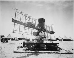
SCR-268 radar in Casablanca, Morocco in WWII
USA Massachusetts location map.svg
Red pog.svg
Calf Island Military Reservation
Location in Massachusetts
Coordinates 42°20′23.80″N70°53′46.17″W / 42.3399444°N 70.8961583°W / 42.3399444; -70.8961583
Type Coastal Defense
Site information
Owner Massachusetts
Controlled by Boston Harbor Islands National Recreation Area
Site history
Built1941
Built byUnited States Army
In use1941-1946
Battles/wars World War II

Calf Island Military Reservation was a World War II coastal defense site located on Calf Island in Hull, Massachusetts.

Contents

History

In 1920 there was a proposal to build a naval-type turret with two 16-inch guns on Great Brewster Island, but this was not implemented. Calf Island was also considered, but the battery was finally built (without a turret) as Fort Duvall. [1]

The Calf Island Military Reservation was built in 1941 on state land. It consisted of an early SCR-268 radar, searchlight station, and an observation post. It was returned to the state in 1946. [2]

The site today

The site today consists of the foundation of the observation tower.

See also

Related Research Articles

<span class="mw-page-title-main">Seacoast defense in the United States</span> Coastal forts construction and maintenance in the U.S.

Seacoast defense was a major concern for the United States from its independence until World War II. Before airplanes, many of America's enemies could only reach it from the sea, making coastal forts an economical alternative to standing armies or a large navy. After the 1940s, it was recognized that fixed fortifications were obsolete and ineffective against aircraft and missiles. However, in prior eras foreign fleets were a realistic threat, and substantial fortifications were built at key locations, especially protecting major harbors.

<span class="mw-page-title-main">Fort Rodman</span> United States historic place

Fort Taber District or the Fort at Clark's Point is a historic American Civil War-era military fort on Wharf Road within the former Fort Rodman Military Reservation in New Bedford, Massachusetts. The fort is now part of Fort Taber Park, a 47-acre town park located at Clark's Point. Fort Taber was an earthwork built nearby with city resources and garrisoned 1861-1863 until Fort Rodman was ready for service.

<span class="mw-page-title-main">Sagamore Hill Military Reservation</span>

Sagamore Hill Military Reservation was a coastal defense site located in Sagamore Beach, Massachusetts. Today, the site is the location of Scusset Beach State Reservation.

<span class="mw-page-title-main">Barneys Joy Point Military Reservation</span> United States Coastal Defense Site

Barneys Joy Point Military Reservation was a World War II coastal defense site located in Dartmouth, Massachusetts.

<span class="mw-page-title-main">Brewster Islands Military Reservation</span> Coastal defense site in Boston Harbor, Massachusetts, USA

Brewster Islands Military Reservation was a coastal defense site located on Great Brewster Island and Outer Brewster Island in Boston Harbor, Massachusetts as part of the Harbor Defenses of Boston.

East Point Military Reservation was a World War I and World War II coastal defense site located in Nahant, Massachusetts. In 1955–62 it was a Nike missile launch site. In 1967 the site was converted into the Marine Science Center of Northeastern University.

<span class="mw-page-title-main">Elizabeth Islands Military Reservation</span>

Elizabeth Islands Military Reservation was a World War II coastal defense site located on Cuttyhunk Island and Nashawena Island in the town of Gosnold, Massachusetts.

<span class="mw-page-title-main">Fourth Cliff Military Reservation</span>

Fourth Cliff Military Reservation was a World War II coastal defense site located near Scituate, Massachusetts, USA. It is now a recreation area for Hanscom Air Force Base.

<span class="mw-page-title-main">Salisbury Beach Military Reservation</span>

Salisbury Beach Military Reservation was a coastal defense site located in Salisbury, Massachusetts.

<span class="mw-page-title-main">Fort Andrews</span>

Fort Andrews was created in 1897 as part of the Coast Defenses of Boston, Massachusetts. Construction began in 1898 and the fort was substantially complete by 1904. The fort was named after Major General George Leonard Andrews, an engineer and Civil War commander, who assisted in the construction of nearby Fort Warren in Boston Harbor. It occupies the entire northeast end of Peddocks Island in Boston Harbor, and was originally called the Peddocks Island Military Reservation. Once an active Coast Artillery post, it was manned by hundreds of soldiers and bristled with mortars and guns that controlled the southern approaches to Boston and Quincy Bay. The fort also served as a prisoner-of-war camp for Italian prisoners during World War II, who were employed as laborers following the Italian surrender to the Allies in 1943. Today, the fort is abandoned, and is managed by the Massachusetts Department of Conservation and Recreation, as part of the Boston Harbor Islands National Recreation Area.

<span class="mw-page-title-main">Fort Heath</span> US seacoast military installation for defense

Fort Heath was a US seacoast military installation for defense of the Boston and Winthrop Harbors with an early 20th-century Coast Artillery fort, a 1930s USCG radio station, prewar naval research facilities, World War II batteries, and a Cold War radar station. The fort was part of the Harbor Defenses of Boston and was garrisoned by the United States Army Coast Artillery Corps. The fort's military structures have been replaced by a residential complex, including the luxurious Forth Heath Apartments, and recreation facilities of Small Park, which has both a commemorative wall and an historical marker for Fort Heath.

<span class="mw-page-title-main">Fort Duvall</span>

Fort Duvall was a Coast Artillery fort, part of the Harbor Defenses of Boston, in Massachusetts. What was then called Hog Island in Hull, Massachusetts was acquired by the U.S. government in 1917, and the fort was constructed in the early 1920s. It had only one gun battery, Battery Long, but it mounted the largest caliber weapons in the entire harbor defense system: a pair of 16-inch guns. These were the 16-inch gun M1919, of which only seven were deployed; 16-inch weapons deployed later were supplied by the Navy.

<span class="mw-page-title-main">Fort Ruckman</span>

Fort Ruckman was a U.S. Coast Artillery fort located in Nahant, Massachusetts. Originally called the Nahant Military Reservation, the fort was laid out in 1904-1907 and covered an area of about 45 acres just northwest of Bass Point, on the southwest side of the Nahant peninsula. During the 1920s, this area was renamed in honor of Maj. Gen. John Wilson Ruckman, a former Colonel in the Coast Artillery.

<span class="mw-page-title-main">Fort Dawes</span>

Fort Dawes was a World War II Coast Artillery fort located on Deer Island in Winthrop/Boston, Massachusetts. It was part of the Harbor Defenses of Boston.

<span class="mw-page-title-main">Fort Revere</span>

Fort Revere is an 8-acre (3.2 ha) historic site situated on a small peninsula located in Hull, Massachusetts. It is situated on Telegraph Hill in Hull Village and contains the remains of two seacoast fortifications, one from the American Revolution and one that served 1898–1947. There are also a water tower with an observation deck, a military history museum and picnic facilities. It is operated as Fort Revere Park by the Metropolitan Park System of Greater Boston.

<span class="mw-page-title-main">Battery Steele</span>

Battery Steele is a United States military fortification on Peaks Island, Portland, Maine in Casco Bay. Completed in 1942 as part of World War II, it is located on 14 acres (5.7 ha) on the oceanside area of the island, formerly part of the Peaks Island Military Reservation. It is named for Harry L. Steele, who was a Coast Artillery officer during World War I. It was armed with two 16-inch MkIIMI guns and, with a 12-inch gun battery at Fort Levett on Cushing Island, replaced all previous heavy guns in the Harbor Defenses of Portland. It was built to protect Casco Bay, particularly Portland harbor, from Kennebunk to Popham Beach in Phippsburg. According to Kim MacIsaac and historian Joel Eastman in An Island at War, “Battery Steele is not only the largest gun battery built on Peaks Island, but also an example of the largest battery ever built anywhere in the United States.” In 1995, after decades of non-use, the Peaks Island Land Preserve, a community land preservation group, formed to purchase the area and forever preserve it as a public space. On October 20, 2005, the property was listed on the National Register of Historic Places. Other coast defense structures on the island include fire control towers and the counterweight for a disappearing searchlight tower.

<span class="mw-page-title-main">Fort Standish (Boston, Massachusetts)</span>

Fort Standish was a coastal fort completed in 1907 and located on Lovell's Island in Massachusetts. Named after Myles Standish, the fort would serve to host up to 7 batteries until it was disarmed and deactivated in 1947. It was also named Lovell's Island Military Reservation during the early part of its existence. It was part of the Coast Defenses of Boston.

<span class="mw-page-title-main">14-inch gun M1907</span> Coastal artillery

The 14-inch Gun M1907 (356 mm) and its variants the M1907MI, M1909, and M1910 were large coastal artillery pieces installed to defend major American seaports between 1895 and 1945. They were operated by the United States Army Coast Artillery Corps. Most were installed on single gun disappearing carriages; the only installation with four guns in twin turrets was built at the unique Fort Drum in Manila Bay, Philippines. All of the weapons not in the Philippines were scrapped during World War II.

<span class="mw-page-title-main">Butler Point Military Reservation</span>

Butler Point Military Reservation was a coastal defense site located in Marion, Massachusetts as part of the defenses of the Cape Cod Canal.

<span class="mw-page-title-main">Harbor Defenses of Boston</span> Military unit

The Harbor Defenses of Boston was a United States Army Coast Artillery Corps harbor defense command. It coordinated the coast defenses of Boston, Massachusetts from 1895 to 1950, beginning with the Endicott program. These included both coast artillery forts and underwater minefields. The command originated circa 1895 as the Boston Artillery District, was renamed Coast Defenses of Boston in 1913, and again renamed Harbor Defenses of Boston in 1925.

References

  1. Parkman, pp. 123-125
  2. "Boston Harbor II - Harbor Defenses of Boston". American Forts Network. Retrieved 18 July 2020.