Related Research Articles
Babson Ledge is a small barren rock within the edge of the Western Harbor and Gloucester Harbor in Gloucester, Massachusetts. The rock is situated south of the Fort Point, Pavilion Beach, Blynman Canal, Route 127, and west of Rocky Neck.
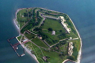
Georges Island is one of the islands in the Boston Harbor, situated just over 7 miles (11 km) from downtown Boston. The island has a permanent size of 39 acres (160,000 m2), plus an intertidal zone of a further 14 acres (57,000 m2), and rises to a height of 50 feet (15 m) above sea level. Historic Fort Warren is on the island. Because of this, and since a ferry operates from Boston to the island, it is a popular destination and one of the easiest islands to access in the Boston Harbor Islands National Recreation Area.

Great Brewster Island is one of the outer islands in the Boston Harbor Islands National Recreation Area, situated some 9 miles (14 km) offshore of downtown Boston. The island has a permanent size of 18 acres (73,000 m2), plus an intertidal zone of a further 49 acres (200,000 m2). Unlike the other outer islands, which are low-lying outcroppings of bedrock, Great Brewster is a drumlin which reaches a height of over 100 feet above sea level. It has vegetation cover consisting of Apple Trees, Pear Trees, Sumac, Beach Roses, Grasses and Common Reeds, together with a large Gull colony. The birds are aggressive during nesting season and access by humans, which is by private boat only, is discouraged during that time.

Outer Brewster Island, also known as Outward Island, is one of the outer islands in the Boston Harbor Islands National Recreation Area and is situated some 10 miles offshore of downtown Boston. The island has a permanent size of 20 acres, and consists of exposed bedrock covered by fertile soil bounded by a rocky shore with steep cliffs. It provides a nesting habitat for coastal water birds, including cormorants, gulls, common eider ducks, glossy ibis and American oystercatchers. The birds are aggressive during their nesting season and access by humans, which is by private boat only, is discouraged during this period.
Middle Brewster Island is a rugged outer island in the Boston Harbor Islands National Recreation Area, located 9 miles (14 km) offshore from downtown Boston. The island has a permanent size of 13 acres (53,000 m2), reaches a height of 52 feet (16 m) above sea level, and is bounded by sharp cliffs and sunken crags. It has only sparse vegetation and serves primarily as a nesting site for gulls and cormorants. The birds are aggressive during their nesting season and access by humans is discouraged during this period. Access is difficult due to the lack of beaches and inlets, and is only accessible by private boat.

Spinnaker Island is an island in the Hingham Bay area of Boston Harbor in Massachusetts, USA. The island is part of the town of Hull, to which it is connected by a bridge, and is one of the few harbor islands that neither forms part of the Boston Harbor Islands National Recreation Area nor is considered within the municipal limits of the city of Boston.

Crowninshield Island, also known as Brown's Island, is a small island off the shore of Marblehead, Massachusetts. Since 1955, it has been maintained by The Trustees of Reservations. For all Trustees of Reservations purposes, the island is referred to as Crowninshield Island, however federally the island is still maintained as "Brown's Island", and it remains better known by that name locally.

Divino is a Brazilian municipality located in the state of Minas Gerais. The city belongs to the mesoregion of Zona da Mata and to the microregion of Muriaé. Divino is 350 km away from the capital of the state of Minas Gerais.

Fort Lee is a historic American Revolutionary War fort in Salem, Massachusetts. The site, located at a high point next to Fort Avenue on Salem Neck, is a relatively rare fortification from that period whose remains are relatively unaltered. It is an irregular 5-pointed star fort. Although there is some documentary evidence that the Neck was fortified as early as the 17th century, the earthworks built in 1776 are the first clear evidence of the site's military use. Reportedly, the fort had a garrison of 3 officers and 100 artillerymen with 16 guns. The site, of which only overgrown earthworks and a stone magazine survive, was repaired in the 1790s, and rebuilt for the American Civil War. A state cultural resource document states that the fort has not been much modified since the Revolution, and has not been built over. It was garrisoned by the Massachusetts militia in the War of 1812, abandoned afterwards, and rebuilt with four 8-inch columbiads in the Civil War. An Army engineer drawing dated 1872 depicts the fort's five-pointed trace and the four Civil War gun positions. It was also garrisoned during the Spanish–American War.

The Misery Islands are an 87-acre (350,000 m2) nature reserve established in 1935 in Salem Sound close to the Salem Harbor in Salem, Massachusetts. It is managed by the Trustees of Reservations. The islands are a part of the city of Salem, although they are much closer to the city of Beverly, in whose aquatic territory they lie.

Trekroner Søfort is a sea fort at the entrance to the Copenhagen harbour. From 1713 until after World War I, Trekroner Fort was part of the fortifications of Copenhagen.

Fort Andrews was created in 1897 as part of the Coast Defenses of Boston, Massachusetts. Construction began in 1898 and the fort was substantially complete by 1904. The fort was named after Major General George Leonard Andrews, an engineer and Civil War commander, who assisted in the construction of nearby Fort Warren in Boston Harbor. It occupies the entire northeast end of Peddocks Island in Boston Harbor, and was originally called the Peddocks Island Military Reservation. Once an active Coast Artillery post, it was manned by hundreds of soldiers and bristled with mortars and guns that controlled the southern approaches to Boston and Quincy Bay. The fort also served as a prisoner-of-war camp for Italian prisoners during World War II, who were employed as laborers following the Italian surrender to the Allies in 1943. Today, the fort is abandoned, and is managed by the Massachusetts Department of Conservation and Recreation, as part of the Boston Harbor Islands National Recreation Area.

Fort Heath was a US seacoast military installation for defense of the Boston and Winthrop Harbors with an early 20th-century Coast Artillery fort, a 1930s USCG radio station, prewar naval research facilities, World War II batteries, and a Cold War radar station. The fort was part of the Harbor Defenses of Boston and was garrisoned by the United States Army Coast Artillery Corps. The fort's military structures have been replaced by a residential complex, including the luxurious Forth Heath Apartments, and recreation facilities of Small Park, which has both a commemorative wall and an historical marker for Fort Heath.

Stage Fort Park is a park at Stage Head in Gloucester, Massachusetts, part of the Essex National Heritage Area. It contains two beaches, a large playground, picnic benches, two baseball fields, a basketball court, a dog park and plenty of room for any weekend activities. The park includes Gloucester's Visitor and Welcome Center and Stage Fort, a reconstructed Civil War fort on a site fortified since 1635.
Beverly Fort was a fort that existed from 1775 to 1776 during the American Revolutionary War on Hospital Point in Beverly, Massachusetts. It was reoccupied in 1814 during the War of 1812. In 1801, a smallpox hospital was built there, which was used in 1814 as a barracks. The J-shaped earthwork of the fort still exists today.
Fort Juniper was a fort that existed from 1775 in Salem, Massachusetts during the American Revolutionary War. It was also known as Fort Number One during its existence.
Fort Nichols was a fort that existed in 1775 in Amesbury, Massachusetts during the American Revolutionary War. It was also known as Fort Merrimac during its existence. Two possible locations for the fort exist. One is a location named Salisbury Point on modern topographic maps, where Interstate 95 crosses the Merrimack River; this is the location of the coordinates given. Another possibility is the mouth of the Merrimack at Salisbury Beach in Salisbury. One source (Heitman) states that the American Civil War Fort at Salisbury Point was built at the same location as Fort Nichols, which is given as "at Salisbury Point, opposite Newburyport". The Civil War fort was sometimes referred to as Fort Nichols by local civilians.

Camp Lander was a former Massachusetts militia camp active during 1862 and located in Wenham, Massachusetts. It was named for Brigadier General Frederick W. Lander, wounded at the Battle of Ball's Bluff, who died of disease almost three weeks later in March 1862. In September–December 1862, the 5th, 8th, and 48th Massachusetts Infantry Regiments trained at the camp. The site is now occupied by Pingree Park, on land donated by Harriet Pingree in 1916.
Camp Guild is a former World War I mobilization camp that existed in 1917 in Boxford, Massachusetts. It was named for Curtis Guild Jr., governor of Massachusetts 1906–1909. Established in World War I and used for an unspecified time thereafter for mustering Massachusetts National Guard troops. In 1926 Camp Curtis Guild was acquired and named by the Commonwealth at another location, thus this camp was presumably defunct by then.
Camp Edwin M. Stanton was an American Civil War training camp that existed from 1861-1862 in Lynnfield, Massachusetts. When the camp first opened in 1861 it was known as Camp Schouler, named for Massachusetts Adjutant General William Schouler. In some references it is mis-spelled as Camp Schuyler. After President Abraham Lincoln's call for 300,000 troops in July 1862, the camp was revived and renamed in honor of United States Secretary of War Edwin M. Stanton. It served as the training camp and rendezvous for recruits from eastern Massachusetts. The camp trained ten infantry regiments and four artillery batteries of the Massachusetts militia, including the 17th, 19th, 22nd, 23rd, 33rd, 35th, 38th, 39th, 40th, and 41st regiments of infantry and the 3rd, 5th, 9th, and 10th batteries of light artillery. Soldiers stationed at Camp Schouler/Stanton during training included Edward A. Wild, Henry Wilson, Nelson A. Miles, Edward Winslow Hinks, and Arthur F. Devereux. During World War I it was renamed Camp Houston and served as a Massachusetts National Guard mobilization camp in 1917. It was located on the Newburyport Turnpike near the Peabody, Massachusetts line. The camp was divided into streets, with tents and cook houses located on both sides of the Turnpike to Suntaug Lake.
References
- ↑ "Massachusetts - Old Stone Fort". American Forts Network. Retrieved 10 July 2020.
- ↑ Heitman, Francis B. (1994). Historical Register And Dictionary Of The United States: 1789-1908 (Reprint. ed.). Baltimore, MD: Genealogical Pub. Co. ISBN 080631401X.
Former military forts, reservations, and camps in Massachusetts | ||
|---|---|---|
| Forts |
|  |
| Reservations | ||
| Camps |
| |
Coordinates: 42°39′38.57″N70°36′52″W / 42.6607139°N 70.61444°W