Winter Island is an island connected by a causeway to Salem Neck in Salem, Massachusetts. It is about 45 acres (18 ha) in size, and is bounded by Smith Pool to the northwest, Cat Cove to the west, Salem Channel to the south and east, and Juniper Cove to the north. The island has about a dozen residences at the north end and one road, Winter Island Road. The Plummer Home for Boys sits on 18 acres (7.3 ha) of land on the northeastern shore. The balance of the island is Winter Island Marine Park. The entire island was added to the National Register of Historic Places as Winter Island Historic District and Archeological District in 1994.

Fort Griswold is a former American defensive fortification in Groton, Connecticut named after Deputy Governor Matthew Griswold. The fort played a key role in the early stages of the American Revolutionary War, in correspondence with Fort Trumbull on the opposite side of the Thames River. Griswold defended the port of New London, Connecticut, a supply center for the Continental Army and friendly port for Connecticut-based privateers who targeted British shipping. The 17-acre site is maintained as Fort Griswold Battlefield State Park by the Connecticut Department of Energy and Environmental Protection.

Fort O'Brien State Historic Site, also known as Fort Machias, preserves the remains of a fort located in Machiasport, Maine that was built and destroyed three times over a 90-year period. It was involved in military actions during the American Revolutionary War and the War of 1812, and was listed on the National Register of Historic Places. It is now managed by the Maine Department of Conservation's Bureau of Parks and Lands, and is open between Memorial Day and Labor Day.

Fort Independence is a granite bastion fort that provided harbor defenses for Boston, Massachusetts, located on Castle Island. Fort Independence is one of the oldest continuously fortified sites of English origin in the United States. The first primitive fortification was called "The Castle", placed on the site in 1634. It was rebuilt twice, then replaced around 1692 with a more substantial structure known as Castle William. It was abandoned by the British during the American Revolution, but the Americans renamed it Fort Adams and then Fort Independence. The existing granite fort was constructed between 1833 and 1851. Today it is preserved as a state park and fires occasional ceremonial salutes. Fort Independence was added to the National Register of Historic Places in 1970.

Plymouth Light, also known as Gurnet Light, is a historic lighthouse located on Gurnet Point at the entrance to Plymouth Bay in the town of Plymouth, Massachusetts. The light is accessible only by passing through the town of Duxbury, which lies to the north. The tower is located inside the earthworks of Fort Andrew, which existed in the Civil War, War of 1812, and Revolutionary War.

Fort Taber District or the Fort at Clark's Point is a historic American Civil War-era military fort on Wharf Road within the former Fort Rodman Military Reservation in New Bedford, Massachusetts. The fort is now part of Fort Taber Park, a 47-acre town park located at Clark's Point. Fort Taber was an earthwork built nearby with city resources and garrisoned 1861-1863 until Fort Rodman was ready for service.

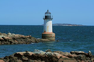
Fort Pickering is a 17th-century historic fort site on Winter Island in Salem, Massachusetts. Fort Pickering operated as a strategic coastal defense and military barracks for Salem Harbor during a variety of periods, serving as a fortification from the Anglo-Dutch Wars through World War II. Construction of the original fort began in 1643 and it saw use as a military installation into the 20th century. Fort Miller in Marblehead also defended Salem's harbor from the 1630s through the American Civil War. Fort Pickering is a First System fortification named for Colonel Timothy Pickering, born in Salem, adjutant general of the Continental Army and secretary of war in 1795. Today, the remains of the fort are open to the public as part of the Winter Island Maritime Park, operated by the City of Salem.

Fort Sewall is a historic coastal fortification in Marblehead, Massachusetts. It is located at Gale's Head, the northeastern point of the main Marblehead peninsula, on a promontory that overlooks the entrance to Marblehead Harbor. Until 1814 it was called Gale's Head Fort.

Fort Andrew is a former fort built as Gurnet Fort in 1776 for the American Revolutionary War on Gurnet Point in Plymouth, Massachusetts. It became a federal fort and was rebuilt in 1808, and again in 1863 during the Civil War when it received its current name. It is named for John A. Andrew, governor of Massachusetts 1861–1866. In 1863 Fort Standish was built nearby on Saquish Head. After the war, the federal government declared Fort Andrew an inactive military reservation in 1869. The reservation was sold in 1926 and mostly became private property, except for the US Coast Guard light station. A World War II fire control tower was built on the parapet of the old fort. Plymouth lighthouse is also on Gurnet Point, and was moved inside the fort's earthworks to protect it from beach erosion in 1997–1998.
Fort George was a palisaded earthwork fort built in 1779 by Great Britain during the American Revolutionary War in Castine, Maine. Located at a high point on the Bagaduce Peninsula, the fort was built as part of an initiative by the British to establish a new colony called New Ireland.

Fort Sullivan was a 19th-century military fortification in Eastport, Maine. It lay opposite New Brunswick, Canada, and served as an important coastal defense for the easternmost United States of America during the 19th century. As part of the establishment of New Ireland during the War of 1812, British Commodore Sir Thomas Hardy, 1st Baronet conquered the fort in 1814 and renamed it Fort Sherbrooke after John Coape Sherbrooke, the Governor of Nova Scotia.
Fort Glover was a fort in Marblehead, Massachusetts. Fortifications on the site existed during the American Revolutionary War, the War of 1812, the Civil War, and the Spanish–American War. The fort was located on what is now Riverhead Beach on Ocean Ave in Marblehead, sited to guard the beach and the Marblehead Neck causeway. It was demolished in 1917.

Fort Defiance was a fort that existed from 1794 to after 1865 on Fort Point in Gloucester, Massachusetts. The location protecting the inner harbor was also called Watch House Point.
Eastern Point Fort was a fort that was garrisoned or maintained from 1863 to 1867 on Eastern Point in Gloucester, Massachusetts, built for the American Civil War. References indicate the name has also been used to refer to the much-older Stage Fort across the harbor.
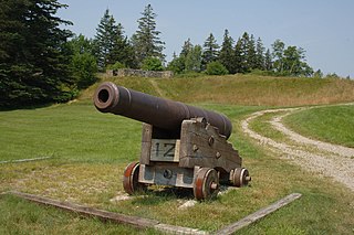
The Fort at Salisbury Point was a fort in use from 1863 to 1865 in Salisbury, Massachusetts, during the American Civil War. It was also called the Fort at Salisbury Beach. It was a nine-gun earthwork located at the mouth of the Merrimack River at what is now the Salisbury Beach State Reservation, where eventual erosion washed it away. A 1903 reference states it was on the site of the Revolutionary War Fort Nichols, but that site is in doubt, and may have been at the location called Salisbury Point in Amesbury, several miles up the river. The Fort at Salisbury Point was sometimes referred to by local civilians as Fort Nichols in the Civil War era. The fort was designed and built under the supervision of Major Charles E. Blunt of the United States Army Corps of Engineers. An armament report dated June 30, 1866 lists nine heavy guns and one 12-pounder field gun. The heavy guns were three 8-inch smoothbore Rodman guns, three 42-pounder rifled guns, and three 30-pounder rifled guns. From November 1864 to June 1865 it was garrisoned by the 20th Unattached Company of Massachusetts militia. The Museum at Salisbury Point commemorates the soldiers who fought in the war.
Fort Standish was a fort built in 1863 for the American Civil War on Saquish Head in Plymouth, Massachusetts. It was named for Myles Standish, military leader of the Plymouth Colony in the 1620s, and augmented the nearby Fort Andrew on Gurnet Point. It was designed and constructed under the supervision of Major Charles E. Blunt of the United States Army Corps of Engineers. The fort had five gun emplacements with five 8-inch smoothbore guns, along with a bombproof shelter, two magazines, and a well. Outside the fort were a barracks, officers' quarters, and a mess hall. From January to June 1865 the fort was garrisoned by the 27th Unattached Company of Massachusetts militia.
Fort Boykin is a historic site in Isle of Wight County, Virginia, located along the James River. The history of the site is believed to date back to 1623 when colonists were ordered to build a fort to protect them from attacking Native Americans or Spanish marauders. Today the remains of the fort, mostly from the American Civil War, are preserved in a public park.

Fort Foster was a military site of the American Revolutionary War in what is now East Machias, Maine. Little more than a large earthworks, it was located on The Rim, a neck of land that commands the confluence of the Machias and East Machias Rivers. The earthworks were built in 1776, and attacked by British forces in the 1777 Battle of Machias. The site was listed on the National Register of Historic Places in 1973.
Fort Miller was a coastal defense fort in Marblehead, Massachusetts, in existence circa 1630–1900. Circa 1861 it was renamed for James Miller, a colonel in the War of 1812, distinguished for his actions in the Battle of Lundy's Lane. He was later Collector of the Port in nearby Salem from 1824 to 1849.

Stage Fort was a fort that existed from 1635 to 1898 on Stage Head in what is now Stage Fort Park in Gloucester, Massachusetts.


