Fort Winthrop

Last updated
Fort Winthrop
Governors Island, Boston Harbor, Massachusetts
FortWinthrop.png
Late 19th-century engraving showing a view of the fort from Boston Harbor
USA Massachusetts location map.svg
Red pog.svg
Fort Winthrop
Location in Massachusetts
Coordinates 42°21′07″N71°00′43″W / 42.35194°N 71.01194°W / 42.35194; -71.01194
Type Coastal Defense
Site information
OwnerLogan Airport
Conditionno remains
Site history
Built1808-1812
Built byLt. Colonel Sylvanus Thayer, US Army Corps of Engineers
In use1812-1905
Demolished1905
Battles/wars War of 1812
American Civil War
1888 map of Boston Harbor showing Governors Island before the airport was built. Situationsplan von Boston (Massachusetts).jpg
1888 map of Boston Harbor showing Governors Island before the airport was built.

Fort Winthrop, built in 1808 and named Fort Warren until 1834, was a defensive fortification in Boston Harbor named after John Winthrop, an early governor of the Massachusetts Bay Colony.

Contents

History

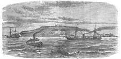
The fort was built on Governors Island, which was named Conant's Island until it was granted to Winthrop in 1632. [1] His family owned the island until 1808, when the United States acquired land in the center of the island for the construction of a fort under the Second System of US fortifications. [2] Between 1808 and 1812 the government built an earthen fort on that land, in the form of an eight-pointed star. [3] Sylvanus Thayer, later famous as Superintendent of West Point, was in charge of the fort's construction. [4] Secretary of War Henry Dearborn's report on fortifications for December 1811 described it as "...a star fort of masonry, mounting twelve guns...and brick barracks for 40 men...On the West head, a circular battery of ten guns mounted [and] on the South point, a circular battery, calculated for ten guns...". [5]

The fort was initially named Fort Warren, after Revolutionary War hero Dr. Joseph Warren, but in 1834 the name was transferred to the new Fort Warren on George's Island. [4]

In 1846 the government acquired the remainder of the island, and construction soon began on a stone fort under the Third System of fortifications. [1] This included a 3-story citadel with numerous musket loopholes and 16 guns in a rooftop battery atop the center of the star fort, and rebuilding of the previous West Head and South-east batteries with seven guns each. [6] Sylvanus Thayer returned to supervise the early years of the citadel's construction, followed by Joseph K. F. Mansfield. [1]

During the Civil War masonry forts (notably Fort Pulaski in Georgia) had not fared well against rifled artillery, and it was determined that new batteries of earthworks were needed. In the 1870s improvements were begun on the fort as part of a large-scale program, including rebuilding the South Battery with 18 guns, a new East Battery of seven guns, and a Mortar Battery of six mortars. [3] Some 15-inch Rodman guns were included in the upgrade. [1] Work was halted on these in 1875 and the fort was in caretaker status with only an Ordnance Sergeant for maintenance until the Spanish–American War in 1898. Following a magazine explosion in 1902, the fort was abandoned in 1905. [4]

Governors Island, which was separated from other harbor islands and the mainland by extensive mudflats, was joined to the mainland in 1946, as part of the expansion of Logan International Airport. Stonework from Fort Winthrop was used to build the foundation of Storrow Drive in Boston.

See also

Related Research Articles

<span class="mw-page-title-main">Fort William and Mary</span> United States historic place

Fort William and Mary was a colonial fortification in Britain's worldwide system of defenses, defended by soldiers of the Province of New Hampshire who reported directly to the royal governor. The fort, originally known as "The Castle," was situated on the island of New Castle, New Hampshire, at the mouth of the Piscataqua River estuary. It was renamed Fort William and Mary circa 1692, after the accession of the monarchs William III and Mary II to the British throne. It was captured by Patriot forces, recaptured, and later abandoned by the British in the Revolutionary War. The fort was renamed Fort Constitution in 1808 following rebuilding. The fort was further rebuilt and expanded through 1899 and served actively through World War II.

<span class="mw-page-title-main">Fort McClary</span> United States historic place

Fort McClary is a former defensive fortification of the United States military located along the southern coast at Kittery Point, Maine at the mouth of the Piscataqua River. It was used throughout the 19th century to protect approaches to the harbor of Portsmouth, New Hampshire and the Portsmouth Naval Shipyard in Kittery. The property and its surviving structures are now owned and operated by the State of Maine as Fort McClary State Historic Site, including a blockhouse dating from 1844.

<span class="mw-page-title-main">House Island (Maine)</span> Private island in Maine, United States

House Island is a private island in Portland Harbor in Casco Bay, Maine, United States. It is part of the City of Portland. The island is accessible only by boat. Public access is prohibited, except for an on-request tour sanctioned by the island's owners. House Island includes three buildings on the east side and Fort Scammell on the west side. The buildings are used as vacation rentals and other summer residences. The island's name derives from the site of an early European house, believed that built by Capt. Christopher Levett, an English explorer of the region.

<span class="mw-page-title-main">Fort Warren (Massachusetts)</span> United States historic place

Fort Warren is a historic fort on the 28-acre (110,000 m2) Georges Island at the entrance to Boston Harbor. The fort is named for Revolutionary War hero Dr. Joseph Warren, who sent Paul Revere on his famous ride, and was later killed at the Battle of Bunker Hill. The name was transferred in 1833 from the first Fort Warren – built in 1808 – which was renamed Fort Winthrop.

<span class="mw-page-title-main">Fort Adams</span>

Fort Adams is a former United States Army post in Newport, Rhode Island, that was established on July 4, 1799, as a First System coastal fortification, named for President John Adams, who was in office at the time. Its first commanding officer was Captain John Henry who was later instrumental in starting the War of 1812. The current Fort Adams was built between 1824 and 1857 under the Third System of coastal forts; it is part of Fort Adams State Park today.

<span class="mw-page-title-main">Fort Preble</span>

Fort Preble was a military fort in South Portland, Maine, United States, built in 1808 and progressively added to through 1906. The fort was active during all major wars from the War of 1812 through World War II. The fort was deactivated in 1950. It is now on the campus of Southern Maine Community College.

<span class="mw-page-title-main">Fort Popham</span> United States historic place

Fort Popham is a Civil War-era coastal defense fortification at the mouth of the Kennebec River in Phippsburg, Maine. It is located in sight of the short-lived Popham Colony and, like the colony, named for George Popham, the colony's leader. The site is preserved as Fort Popham State Historic Site.

<span class="mw-page-title-main">Fort Independence (Massachusetts)</span> United States historic place

Fort Independence is a granite bastion fort that provided harbor defenses for Boston, Massachusetts, located on Castle Island. Fort Independence is one of the oldest continuously fortified sites of English origin in the United States. The first primitive fortification was called "The Castle", placed on the site in 1634. It was rebuilt twice, then replaced around 1692 with a more substantial structure known as Castle William. It was abandoned by the British during the American Revolution, but the Americans renamed it Fort Adams and then Fort Independence. The existing granite fort was constructed between 1833 and 1851. Today it is preserved as a state park and fires occasional ceremonial salutes. Fort Independence was added to the National Register of Historic Places in 1970.

<span class="mw-page-title-main">Seacoast defense in the United States</span> Coastal forts construction and maintenance in the U.S.

Seacoast defense was a major concern for the United States from its independence until World War II. Before airplanes, many of America's enemies could only reach it from the sea, making coastal forts an economical alternative to standing armies or a large navy. After the 1940s, it was recognized that fixed fortifications were obsolete and ineffective against aircraft and missiles. However, in prior eras foreign fleets were a realistic threat, and substantial fortifications were built at key locations, especially protecting major harbors.

<span class="mw-page-title-main">Fort Andrews</span>

Fort Andrews was created in 1897 as part of the Coast Defenses of Boston, Massachusetts. Construction began in 1898 and the fort was substantially complete by 1904. The fort was named after Major General George Leonard Andrews, an engineer and Civil War commander, who assisted in the construction of nearby Fort Warren in Boston Harbor. It occupies the entire northeast end of Peddocks Island in Boston Harbor, and was originally called the Peddocks Island Military Reservation. Once an active Coast Artillery post, it was manned by hundreds of soldiers and bristled with mortars and guns that controlled the southern approaches to Boston and Quincy Bay. The fort also served as a prisoner-of-war camp for Italian prisoners during World War II, who were employed as laborers following the Italian surrender to the Allies in 1943. Today, the fort is abandoned, and is managed by the Massachusetts Department of Conservation and Recreation, as part of the Boston Harbor Islands National Recreation Area.

<span class="mw-page-title-main">Fort Banks (Massachusetts)</span> American military base

Fort Banks was a U.S. Coast Artillery fort located in Winthrop, Massachusetts. It served to defend Boston Harbor from enemy attack from the sea and was built in the 1809 during what is known as the Endicott period, a time in which the coast defenses of the United States were seriously expanded and upgraded with new technology. Today, the fort's mortar battery is on the National Register of Historic Places.

<span class="mw-page-title-main">Fort Heath</span> US seacoast military installation for defense

Fort Heath was a US seacoast military installation for defense of the Boston and Winthrop Harbors with an early 20th-century Coast Artillery fort, a 1930s USCG radio station, prewar naval research facilities, World War II batteries, and a Cold War radar station. The fort was part of the Harbor Defenses of Boston and was garrisoned by the United States Army Coast Artillery Corps. The fort's military structures have been replaced by a residential complex, including the luxurious Forth Heath Apartments, and recreation facilities of Small Park, which has both a commemorative wall and an historical marker for Fort Heath.

<span class="mw-page-title-main">Fort Dawes</span>

Fort Dawes was a World War II Coast Artillery fort located on Deer Island in Winthrop/Boston, Massachusetts. It was part of the Harbor Defenses of Boston.

<span class="mw-page-title-main">Fort Revere</span>

Fort Revere is an 8-acre (3.2 ha) historic site situated on a small peninsula located in Hull, Massachusetts. It is situated on Telegraph Hill in Hull Village and contains the remains of two seacoast fortifications, one from the American Revolution and one that served 1898–1947. There are also a water tower with an observation deck, a military history museum and picnic facilities. It is operated as Fort Revere Park by the Metropolitan Park System of Greater Boston.

<span class="mw-page-title-main">Fort Defiance (Massachusetts)</span>

Fort Defiance was a fort that existed from 1794 to after 1865 on Fort Point in Gloucester, Massachusetts. The location protecting the inner harbor was also called Watch House Point.

<span class="mw-page-title-main">Fort Sumner (Maine)</span>

Fort Sumner was a coastal defense fortification on Munjoy Hill in Portland, Maine, United States. It was built in 1794 as part of the first system of coastal fortifications built by the United States. It was reportedly originally named Fort Allen after the nearby Revolutionary War battery that probably became part of Fort Sumner, but was renamed in 1797 after Increase Sumner, the incumbent Governor of Massachusetts, of which Maine was then a part. The location is now Fort Sumner Park.

<span class="mw-page-title-main">Harbor Defenses of Portland</span> Military unit

The Harbor Defenses of Portland was a United States Army Coast Artillery Corps harbor defense command. It coordinated the coast defenses of Portland, Maine, the mouth of the Kennebec River, and surrounding areas from 1895 to 1950, beginning with the Endicott program. These included both coast artillery forts and underwater minefields. The command originated circa 1895 as the Portland Artillery District, was renamed Coast Defenses of Portland in 1913, and again renamed Harbor Defenses of Portland in 1925.

The Harbor Defenses of Portsmouth was a United States Army Coast Artillery Corps harbor defense command. It coordinated the coast defenses of Portsmouth, New Hampshire and the nearby Portsmouth Naval Shipyard in Kittery, Maine from 1900 to 1950, both on the Piscataqua River, beginning with the Endicott program. These included both coast artillery forts and underwater minefields. The command originated circa 1900 as the Portsmouth Artillery District, was renamed Coast Defenses of Portsmouth in 1913, and again renamed Harbor Defenses of Portsmouth in 1925.

<span class="mw-page-title-main">Harbor Defenses of Boston</span> Military unit

The Harbor Defenses of Boston was a United States Army Coast Artillery Corps harbor defense command. It coordinated the coast defenses of Boston, Massachusetts from 1895 to 1950, beginning with the Endicott program. These included both coast artillery forts and underwater minefields. The command originated circa 1895 as the Boston Artillery District, was renamed Coast Defenses of Boston in 1913, and again renamed Harbor Defenses of Boston in 1925.

References

  1. 1 2 3 4 Commins, Mabel P., "Fort Winthrop: Its Past and Present History", The Bostonian, Vol. II, August 1895, pp. 491-501, access date 24 March 2016 (web page title "National Magazine")
  2. "Boston Illustrated - VI - The Harbor". Boston And New York Houghton, Mifflin And Company (1891). Retrieved October 15, 2006.
  3. 1 2 Fort Winthrop at NorthAmericanForts.com
  4. 1 2 3 Fort Winthrop at FortWiki.com
  5. Wade, p.242
  6. Weaver, pp. 109–112

Bibliography