Fort Strong

Last updated
Fort Strong
Part of Harbor Defenses of Boston
Long Island, Massachusetts
10-inch-1896-DC.jpg
A 10-inch disappearing gun, similar to those of Batteries Hitchcock and Ward.
USA Massachusetts location map.svg
Red pog.svg
Fort Strong
Location in Massachusetts
Coordinates 42°19′47.96″N70°57′21.53″W / 42.3299889°N 70.9559806°W / 42.3299889; -70.9559806
Type Coastal Defense
Site information
Owner Massachusetts
Controlled byCity of Boston
Site history
Built1899
Built byUnited States Army
In use1899-1961
Battles/wars World War I
World War II
Cold War
A 1938 map of the fort. Ft Strong Map 1938.jpg
A 1938 map of the fort.

Fort Strong is a former U.S. Army Coast Artillery fort that occupied the northern third of Long Island in Boston Harbor. The island had a training camp during the American Civil War, and a gun battery was built there in the 1870s. The fort was built in 1893-1906 during the Endicott period of expansion in U.S. coast defense, and was part of the Coast (later Harbor) Defenses of Boston. Formerly, it was also known as Long Island Military Reservation. Before World War I, a large station for handling submarine mines was added to the fort's defenses. Prior to World War I the fort was probably manned by over 1,000 soldiers. During World War II, two batteries of 3-inch guns (Basinger and Stevens) defended channel minefields, but the big guns and other 3-inch batteries (except for the AA guns) were decommissioned. Declared surplus in 1947, the fort served as a Nike missile site until 1961, and was redeveloped in 2005-2009 for a children's summer camp and later a homeless shelter. [1] However, in 2014 the island's bridge was demolished due to safety concerns, and all activity ended. [2] [3]

Contents

Origins

The "obsolete" (1874) cannon battery was included on a 1922 map of Battery Ward. Ft-Strong-Obsolete-Bty.jpg
The "obsolete" (1874) cannon battery was included on a 1922 map of Battery Ward.

The fort had its origins in the Civil War period. Camp Wightman, a Civil War training camp, was located on the island in 1861. At the end of the Civil War, the state government decided to name a new battery on Long Island for the old Fort Strong, a Revolutionary War and War of 1812 earthwork which had been located in East Boston on Noddle's Island. [4] The old fort and the Long Island Head Battery were named for Massachusetts Governor Caleb Strong, [5] while the new fort was named for Major General George C. Strong in 1899. [6] Until 1899, the fort was also named the Long Island Military Reservation. From 1874 to 1876, the fort had a battery of 10 cannon, called the Long Island Head Battery, on the northeast tip of the raised northern portion of the island. [4] Remains of this battery can still be found, concealed by heavy brush, about 100 feet (30 m) north of Battery Ward, the easternmost concrete battery on the tip of the island (see the map of the "Obsolete Battery").

In 1893, as part of the Endicott Board's recommendations, construction began at the fort on a series of massive concrete gun batteries to defend the harbor approaches. A large barracks building for the soldiers and a series of quarters for officers and NCOs were also constructed, as well as structures for mining operations and support functions at the fort. The fort was named in General Order 134, 22 July 1899, for Brigadier General George Crockett Strong. [6]

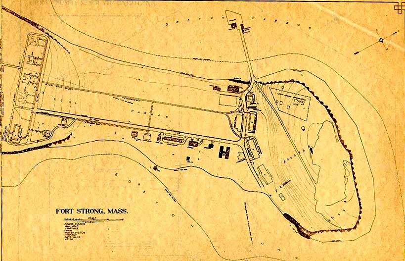
A quick look at the map will show how Fort Strong's central location made it so well suited for harbor defense. Its principal armament (the 10-inch guns) could engage any ship attempting to enter either the northern or southern approaches to the harbor, while its smaller rapid fire (3-inch) guns could fire directly over all approach channels and the mine fields that criss-crossed them.

Modern Gun Batteries

The platform of 10-inch Gun #1, Battery Hitchcock. Hitchcock Gun 1.jpg
The platform of 10-inch Gun #1, Battery Hitchcock.
The casemate of Battery Smyth (3-inch guns). Battery-Smyth.jpg
The casemate of Battery Smyth (3-inch guns).
A 3-inch M1902 seacoast gun. All but one of Fort Strong's 3-inch batteries mounted this type of gun. 3-inch-gun-M1902.jpg
A 3-inch M1902 seacoast gun. All but one of Fort Strong's 3-inch batteries mounted this type of gun.
A cutaway drawing showing the workings of the disappearing carriage, M1896. 10-inch-D1896-cutaway.jpg
A cutaway drawing showing the workings of the disappearing carriage, M1896.
View of Deer Island and the channel from Battery Basinger. View-of-Deer-Island.jpg
View of Deer Island and the channel from Battery Basinger.

The Endicott-era and later gun batteries at Fort Strong were: [6] [7] [8]

NameNo. of gunsGun typeCarriage typeYears active
Hitchcock3 10-inch gun M1888 disappearing, 2 M1894, 1 M18961899-1939
Ward 2 10-inch gun M1888 disappearing M18941899-1939
Drum2 4.72-inch/40 caliber Armstrong gun pedestal1899-1917
Basinger2 3-inch gun M1898 masking parapet M18981906-1947
Smyth 2 3-inch gun M1902 pedestal1906-1921
Stevens 2 3-inch gun M1902 pedestal1906-1946
Taylor 2 3-inch gun M1902 pedestal1906-1942

The main armament of Fort Strong was its two batteries of 10-inch guns on disappearing carriages, totaling five guns. Originally, two of these guns were located in Battery Ward, the easternmost concrete fortification on Long Island Head, and three more in Battery Hitchcock, immediately to its west. The construction of these batteries, begun in 1893, was completed in 1899. [6] Electrically powered ammunition and powder hoists were added soon after. [9] With a maximum range of 14,000 yards (13,000 m), or almost 8 miles, [10] these guns covered an arc from Revere to North Scituate. The batteries were intended to engage medium and larger sized ships as directed by the fire control system.

Battery Drum, at the extreme northwestern end of the gun line on Long Island Head, mounted two 4.7-inch Armstrong guns on pedestal mounts. [6] These were part of a series of batteries hastily ordered after the outbreak of the Spanish–American War in 1898. It was feared that the Spanish Navy would bombard the US east coast. Most Endicott batteries were still years from completion, especially the 3-inch and 6-inch batteries. Some 6-inch and 4.7-inch guns were purchased from the United Kingdom and mounted at the Endicott forts still under construction, including the two 4.7-inch guns at Fort Strong. [11]

Fort Strong also had four batteries of 3-inch rapid fire guns, with two guns each (or 8 guns total). Battery Basinger (with two 3-inch M1898 guns) was completed in 1901, the remainder (each with two 3-inch M1902 guns) were completed in 1906. [6] These guns were meant to engage faster moving targets by means of direct fire, and were sited to protect the mine fields that had been laid to block the harbor channels. They could deliver fire up to a range of 11,000 yards (10,000 m), or 6.25 miles. [10] Battery Stevens and Battery Smyth were located on the southeast side of the fort, looking out over the channel between Long Island and Hull. Battery Taylor was on the southwest side, looking out toward Spectacle Island, and Battery Basinger was located on the northern tip of the fort (just downslope from the 10-inch gun batteries), looking across toward Fort Dawes on Deer Island.

The latter three of these batteries were located in classic Coast Artillery 3-inch gun emplacements, each with two raised gun platforms, one on either side of a large central casemated magazine. Battery Basinger, however, was squeezed into the narrow space above the sea wall, its gun platforms more like narrow tubs at the water's edge. This battery had a unique underground magazine with hand-operated chain hoists to serve ammunition to its two guns.

Each of the 10-inch guns was intended to be served by a full-strength complement of 43 enlisted men, so the five guns of the two batteries would have required a total of 215 crew. Manning the four 3-inch batteries (when all their guns were present) would have required roughly another 100 men in total. Add to this the mine and searchlight defenses, the maintenance and support functions of the fort, and its officer, and about 450 soldiers likely manned the fort, living in large barracks buildings and smaller houses that surrounded the parade ground.

World War I through World War II

The American entry into World War I in early 1917 brought many changes at Fort Strong. In October 1917 the two 4.7-inch guns of Battery Drum were relocated to Sachuest Point in Middletown, Rhode Island. This is misspelled on the gun cards as "Sauchet Point". These guns were removed in 1919; one was scrapped and one remains as a memorial in Ansonia, Connecticut. [12] [13] All three guns of Battery Hitchcock were dismounted for potential service on the Western Front as railway artillery. In June 1918 one of these guns was shipped out for the railway gun program, but the other two were remounted. The transferred gun was never replaced. [6] Also, a two-gun battery of Model 1917A2 3-in antiaircraft guns was constructed on the northwest side of the parade ground during 1917-18. In 1935, a third gun was added to this battery, which remained active through World War II.

In 1920-1921 the 3-inch M1898 Driggs-Seabury guns of Battery Basinger were removed and scrapped, part of a withdrawal from service of this type of weapon. The 3-inch M1902 guns of Battery Smyth were transferred to Battery Basinger; Battery Smyth was never re-armed. [6]

In 1938-1939 all of Fort Strong's four remaining 10-inch guns were removed and scrapped. In 1942 Battery Taylor's two 3-inch guns (and name) were transferred to Fort Dawes on Deer Island. This left the four 3-inch guns of Batteries Basinger and Stevens and the 3-inch antiaircraft battery as Fort Strong's only armament. [6]

During and for some period after World War II Fort Strong hosted an Army Intelligence Service post.

Post World War II

In 1945-46 German rocket scientist Wernher von Braun and six others were secretly housed at the Army Intelligence Service post at Fort Strong.

In 1946 Fort Strong's remaining guns were scrapped. A radar site for the 90 mm antiaircraft gun system (Site B-35) was at the site 1952-1958. [7] Fort Strong was a Nike missile launch site (B-37L) in the 1950s, with the control site in Squantum. [7] The Radar Section, 15th Antiaircraft Artillery Group, was there from January 1958 to June 1961. [6]

The property to the south of the fort was at one time the Long Island State Hospital, and is now operated by the Boston Public Health Commission.

In 2014 the bridge to Long Island was demolished due to safety concerns and all activities there ceased. [2] In 2016 an organic farm was restarted on the island by a local fast food chain. [14] [15]

See also

Related Research Articles

<span class="mw-page-title-main">Fort Schuyler</span>

Fort Schuyler is a preserved 19th century fortification in the New York City borough of the Bronx. It houses a museum, the Stephen B. Luce Library, and the Marine Transportation Department and Administrative offices of the State University of New York Maritime College. It is considered one of the finest examples of early 19th century fortifications. The fort was named in honor of Major General Philip Schuyler of the Continental Army.

<span class="mw-page-title-main">Dutch Island (Rhode Island)</span>

Dutch Island is an island lying west of Conanicut Island at an entrance to Narragansett Bay in Rhode Island, United States. It is part of the town of Jamestown, Rhode Island, and has a land area of 0.4156 km². It was uninhabited as of the United States Census, 2000. The island was fortified from the American Civil War through World War II and was known as Fort Greble from 1898 to 1947.

<span class="mw-page-title-main">Seacoast defense in the United States</span> Coastal forts construction and maintenance in the U.S.

Seacoast defense was a major concern for the United States from its independence until World War II. Before airplanes, many of America's enemies could only reach it from the sea, making coastal forts an economical alternative to standing armies or a large navy. After the 1940s, it was recognized that fixed fortifications were obsolete and ineffective against aircraft and missiles. However, in prior eras foreign fleets were a realistic threat, and substantial fortifications were built at key locations, especially protecting major harbors.

<span class="mw-page-title-main">Fort Wetherill</span> Historic site in Rhode Island, United States

Fort Wetherill is a former coast artillery fort that occupies the southern portion of the eastern tip of Conanicut Island in Jamestown, Rhode Island. It sits atop high granite cliffs, overlooking the entrance to Narragansett Bay. Fort Dumpling from the American Revolutionary War occupied the site until it was built over by Fort Wetherill. Wetherill was deactivated and turned over to the State of Rhode Island after World War II and is now operated as Fort Wetherill State Park, a 51-acre (210,000 m2) reservation managed by the Rhode Island Department of Environmental Management.

<span class="mw-page-title-main">Fort Levett</span>

Fort Levett was a former U.S. Army fort built on Cushing Island, Maine, beginning in 1898. Located in Cumberland County, Maine, in Casco Bay near Portland, Maine, the fort was heavily fortified with guns for coastal defense. Conceived under the Endicott Program in 1885 and begun in the wake of the Spanish–American War, Fort Levett was manned during both world wars. It was part of the Coast Defenses of Portland, later renamed the Harbor Defenses of Portland, a command which protected Portland's port and naval anchorage from 1904 to 1950. The fort's name is sometimes misspelled "Leavitt".

<span class="mw-page-title-main">Fort Andrews</span>

Fort Andrews was created in 1897 as part of the Coast Defenses of Boston, Massachusetts. Construction began in 1898 and the fort was substantially complete by 1904. The fort was named after Major General George Leonard Andrews, an engineer and Civil War commander, who assisted in the construction of nearby Fort Warren in Boston Harbor. It occupies the entire northeast end of Peddocks Island in Boston Harbor, and was originally called the Peddocks Island Military Reservation. Once an active Coast Artillery post, it was manned by hundreds of soldiers and bristled with mortars and guns that controlled the southern approaches to Boston and Quincy Bay. The fort also served as a prisoner-of-war camp for Italian prisoners during World War II, who were employed as laborers following the Italian surrender to the Allies in 1943. Today, the fort is abandoned, and is managed by the Massachusetts Department of Conservation and Recreation, as part of the Boston Harbor Islands National Recreation Area.

<span class="mw-page-title-main">Fort Dawes</span>

Fort Dawes was a World War II Coast Artillery fort located on Deer Island in Winthrop/Boston, Massachusetts. It was part of the Harbor Defenses of Boston.

<span class="mw-page-title-main">Fort Revere</span>

Fort Revere is an 8-acre (3.2 ha) historic site situated on a small peninsula located in Hull, Massachusetts. It is situated on Telegraph Hill in Hull Village and contains the remains of two seacoast fortifications, one from the American Revolution and one that served 1898–1947. There are also a water tower with an observation deck, a military history museum and picnic facilities. It is operated as Fort Revere Park by the Metropolitan Park System of Greater Boston.

<span class="mw-page-title-main">Fort McKinley (Maine)</span> United States historic place

Fort McKinley is a former United States Army coastal defense fort on Great Diamond Island, Maine in Casco Bay, which operated from 1873 to 1947. It was named for President William McKinley. It included a sub-post, Fort Lyon, on Cow Island, just north of Great Diamond Island. Fort Lyon was named for Nathaniel Lyon. Both forts were part of the Coast Defenses of Portland, renamed the Harbor Defenses of Portland in 1925, a command which protected Portland's port and naval anchorage 1895-1950. In 1946 Fort Lyon was closed and turned over to the City of Portland. After Fort McKinley's closure it was transferred to the United States Navy, which sold the site to private interests in 1961. The Fort McKinley Historic District was listed on the National Register of Historic Places in 1985.

<span class="mw-page-title-main">3-inch gun M1903</span> Rapid-fire seacoast gun

The 3-inch gun M1903 and its predecessors the M1898 and M1902 were rapid fire breech-loading artillery guns with a 360-degree traverse. In some references they are called "15-pounders" due to their projectile weight. They were originally emplaced from 1899 to 1917 and served until shortly after World War II. These 3-inch guns were placed to provide fire to protect underwater mines and nets against minesweepers, and also to protect against motor torpedo boats. In some documentation they are called "mine defense guns". The 3-inch guns were mounted on pedestal mounts that bolted into a concrete emplacement that provided cover and safety for the gun's crew.

<span class="mw-page-title-main">Fort Standish (Boston, Massachusetts)</span>

Fort Standish was a coastal fort completed in 1907 and located on Lovell's Island in Massachusetts. Named after Myles Standish, the fort would serve to host up to 7 batteries until it was disarmed and deactivated in 1947. It was also named Lovell's Island Military Reservation during the early part of its existence. It was part of the Coast Defenses of Boston.

<span class="mw-page-title-main">Fort Foster (Kittery, Maine)</span>

Fort Foster, now part of Fort Foster Park, is a historic fort active 1901–1946 on the southwest tip of Gerrish Island in the Kittery Point area of Kittery, Maine. The park includes beaches and trails. Battery Bohlen and Battery Chapin were the major parts of the fort.

<span class="mw-page-title-main">10-inch gun M1895</span> Coastal artillery

The 10-inch Gun M1895 (254 mm) and its variants the M1888 and M1900 were large coastal artillery pieces installed to defend major American seaports between 1895 and 1945. For most of their history they were operated by the United States Army Coast Artillery Corps. Most were installed on disappearing carriages, with early installations on barbette mountings. All of the weapons not in the Philippines were scrapped during World War II. Two of the surviving weapons were relocated from the Philippines to Fort Casey in Washington state in the 1960s.

<span class="mw-page-title-main">14-inch gun M1907</span> Coastal artillery

The 14-inch Gun M1907 (356 mm) and its variants the M1907MI, M1909, and M1910 were large coastal artillery pieces installed to defend major American seaports between 1895 and 1945. They were operated by the United States Army Coast Artillery Corps. Most were installed on single gun disappearing carriages; the only installation with four guns in twin turrets was built at the unique Fort Drum in Manila Bay, Philippines. All of the weapons not in the Philippines were scrapped during World War II.

<span class="mw-page-title-main">Camp Varnum</span>

Camp Varnum is a Rhode Island Army National Guard training facility in the Boston Neck area of Narragansett, Rhode Island. During World War II it was Fort Varnum, a coastal defense fort.

<span class="mw-page-title-main">Fort Armistead</span> United States Army coastal defense fort

Fort Armistead was a United States Army coastal defense fort, active from 1901 to 1920, that defended Baltimore, Maryland.

The Harbor Defenses of Portsmouth was a United States Army Coast Artillery Corps harbor defense command. It coordinated the coast defenses of Portsmouth, New Hampshire and the nearby Portsmouth Naval Shipyard in Kittery, Maine from 1900 to 1950, both on the Piscataqua River, beginning with the Endicott program. These included both coast artillery forts and underwater minefields. The command originated circa 1900 as the Portsmouth Artillery District, was renamed Coast Defenses of Portsmouth in 1913, and again renamed Harbor Defenses of Portsmouth in 1925.

<span class="mw-page-title-main">Harbor Defenses of Boston</span> Military unit

The Harbor Defenses of Boston was a United States Army Coast Artillery Corps harbor defense command. It coordinated the coast defenses of Boston, Massachusetts from 1895 to 1950, beginning with the Endicott program. These included both coast artillery forts and underwater minefields. The command originated circa 1895 as the Boston Artillery District, was renamed Coast Defenses of Boston in 1913, and again renamed Harbor Defenses of Boston in 1925.

<span class="mw-page-title-main">Harbor Defenses of New Bedford</span> Military unit

The Harbor Defenses of New Bedford was a United States Army Coast Artillery Corps harbor defense command. It coordinated the coast defenses of New Bedford, Massachusetts and the nearby Cape Cod Canal from 1900 to 1950, beginning with the Endicott program. These included a coast artillery fort and an underwater minefield. The command originated circa 1900 as the New Bedford Artillery District, was renamed Coast Defenses of New Bedford in 1913, and again renamed Harbor Defenses of New Bedford in 1925.

References

  1. The camp was designed to serve youth from the City of Boston and straddled the former parade ground of the fort. Building the camp involved demolition of almost all the wooden structures of the fort and raised the elevation of the former parade ground by several feet.
  2. 1 2 "Mayor Walsh provides update on the Long Island Bridge". The Official Website of the City of Boston. November 26, 2014. Retrieved November 29, 2014.
  3. Abel, David, "On Long Island, haunting signs of a hasty departure: The pieces left behind at island’s shelters highlight uncertainty", The Boston Globe, October 28, 2014
  4. 1 2 Fort Strong (1) at NorthAmericanForts.com
  5. Snow, Edward Rowe, Sailing Down Boston Bay, 1941. cf. p.24, Fort Strong on Long Island
  6. 1 2 3 4 5 6 7 8 9 10 Fort Strong at FortWiki.com
  7. 1 2 3 Fort Strong (2) at NorthAmericanForts.com
  8. Berhow, p. 205
  9. Each shell weighed just over 600 lbs. and its propellant powder about 150 lbs., so these hoists were a great improvement over winching the ammunition up to the loading platforms by hand, using pulley-and-davit systems suspended from the rear of the platforms. See The Service of Coast Artillery, Frank T. Hines and Franklin W. Ward, New York: Goodenough & Woglom Co., 1910. pp. 125-126.
  10. 1 2 Berhow, p. 61
  11. Congressional serial set, 1900, Report of the Commission on the Conduct of the War with Spain, Vol. 7, pp. 3778–3780, Washington: Government Printing Office
  12. Gun and Carriage cards, National Archives and Records Administration, Record Group 156, Records of the Chief of Ordnance, Entry 712
  13. Berhow, p. 239
  14. Abel, David, "Farm that once benefited the homeless now run by fast-food chain", The Boston Globe, print edition, July 25, 2016
  15. b.good restaurant website Cf. section on Long Island Farm.