Mission Bay, New Zealand

Last updated

Mission Bay
Mission Bay Beach - Auckland 2017.jpg
View of Mission Bay Beach
Mission Bay, New Zealand
Coordinates: 36°50′53″S174°49′50″E / 36.84817°S 174.83059°E / -36.84817; 174.83059
CountryNew Zealand
City Auckland
Local authority Auckland Council
Electoral ward Ōrākei ward
Local board Ōrākei Local Board
Area
[1]
  Land154 ha (381 acres)
Population
 (June 2023) [2]
  Total4,500
Waitematā Harbour, Devonport Hauraki Gulf Rangitoto Island
Okahu Bay
Pfeil oben.svg
Pfeil links.svgMission BayPfeil rechts.svg
Pfeil unten.svg
Kohimarama, Saint Heliers, Glendowie
Ōrākei Meadowbank Kohimarama, St Johns

Mission Bay is a seaside suburb of Auckland city, on the North Island of New Zealand. The suburb's beach is a popular resort, located alongside Tamaki Drive. [3] The area also has a wide range of eateries. Mission Bay is located seven kilometres to the east of the city centre, on the southern shore of the Waitematā Harbour, between Ōrākei and Kohimarama. It covers an area of 1.08 km2 (267 acres), about three quarters of which comprises low hills, surrounding the remaining quarter, which slopes down to the sea. Local government of Mission Bay is the responsibility of the Ōrākei Local Board, which also includes the suburbs of Ōrākei, Kohimarama, St Heliers, Glendowie, St Johns, Meadowbank, Remuera and Ellerslie.

Contents

Demographics

Mission Bay covers 1.54 km2 (0.59 sq mi) [1] and had an estimated population of 4,500 as of June 2023, [2] with a population density of 2,922 people per km2.

Historical population
YearPop.±% p.a.
20064,134    
20134,191+0.20%
20184,341+0.71%
Source: [4]

Mission Bay had a population of 4,341 at the 2018 New Zealand census, an increase of 150 people (3.6%) since the 2013 census, and an increase of 207 people (5.0%) since the 2006 census. There were 1,677 households, comprising 2,016 males and 2,325 females, giving a sex ratio of 0.87 males per female. The median age was 43.3 years (compared with 37.4 years nationally), with 612 people (14.1%) aged under 15 years, 801 (18.5%) aged 15 to 29, 2,115 (48.7%) aged 30 to 64, and 819 (18.9%) aged 65 or older.

Ethnicities were 78.1% European/Pākehā, 4.3% Māori, 1.8% Pacific peoples, 17.7% Asian, and 4.8% other ethnicities. People may identify with more than one ethnicity.

The percentage of people born overseas was 39.3, compared with 27.1% nationally.

Although some people chose not to answer the census's question about religious affiliation, 47.8% had no religion, 40.6% were Christian, 0.1% had Māori religious beliefs, 1.9% were Hindu, 1.0% were Muslim, 1.5% were Buddhist and 2.2% had other religions.

Of those at least 15 years old, 1,695 (45.5%) people had a bachelor's or higher degree, and 234 (6.3%) people had no formal qualifications. The median income was $49,400, compared with $31,800 nationally. 1,338 people (35.9%) earned over $70,000 compared to 17.2% nationally. The employment status of those at least 15 was that 1,983 (53.2%) people were employed full-time, 513 (13.8%) were part-time, and 87 (2.3%) were unemployed. [4]

History

Mission buildings at Selwyn Reserve Missionbay nz.JPG
Mission buildings at Selwyn Reserve

Mission Bay sits on three parcels of land comprising part of the Kohimarama block bought from the Crown in the early 1840s. The area used to be referred to as ‘Kohimarama’, a name now given to a neighbouring suburb Kohimarama. [3] Present-day Mission Bay takes its name from the Melanesian Mission, which was established by the Anglican Bishop George Augustus Selwyn at the bay at the end of the 1840s. The school also known as St Andrew's College, was an Anglican institution set up to provide Melanesian boys with a Christian education. [5] The stone buildings, designed by Reader Wood, date from 1858 and are built of scoria rock quarried on the volcanic island of Rangitoto.

In the winter of 1860 the mission buildings were lent to the Governor, Colonel Thomas Gore Browne, who organised the historic Kohimarama Conference. [3] The conference was attended by 200 rangatira from a large number of iwi throughout New Zealand and aimed at convincing Māori leaders to reject the Māori King Movement and justify the Government’s war in Taranaki, which had broken out over a disputed land transaction. [6] The conference lasted a month. A wide range of issues were discussed. It gave southern Māori in particular an opportunity to gain a fuller understanding of the meaning of the treaty. In the last week Paora Tuarere (Ngati Whatua) proposed that the treaty should be endorsed by the conference as a "fuller ratification". Tuarere was one of the principal chiefs who gave and sold land to the government in Auckland on the Auckland isthmus. [7] Māori then affirmed the treaty thus reassuring the government that Māori would, in general, support the government rather than the new Māori king. The kingite Wiremu Tamahana attended the conference. [8] The Kohimarama Conference is said to be unique, since it was the first time Māori had been given the opportunity to hold a rūnanga with Pākehā officials, which was a first step towards representation in the Government of New Zealand. [3]

The Anglican Mission was transferred to Norfolk Island in 1867, but St. Andrews College remained an educational institution, serving as a naval training school, industrial school, and institute for teaching work practices to ‘neglected’ boys.

Mission Bay, was the second location for the Walsh Brothers New Zealand Flying School after moving from Ōrākei in November 1915. [9] For many years they used the bay as a landing area for their seaplanes. It is claimed that during this time they trained at least a third of the New Zealand’s pilots active during the First World War. Hence, Mission Bay was also known as ‘Flying School Bay’. [10] The school closed in 1924, after training over 1,000 pilots. [9]

In 1928 the mission building became a museum, but was found to be unsuitable for the display of artifacts. It was taken over as a heritage property by Heritage New Zealand in 1974 and the former St. Andrews College has since been leased out as a restaurant. [10]

Economy

Retail

The waterfront Mission Bay Shopping Precinct has about 44 retailers, including a four-screen Reading Cinema, with on-street parking. [11]

Eastridge Shopping Centre, located on the upper side of the Mission Bay suburb, has 32 stores including a New World supermarket. [12]

Landmarks and features

Bastion Point

Bastion Point (Takaparawhau in Māori), located on the northern end of the Mission Bay, had strategic importance for both Māori and Pākehā. Its commanding view over the entrance to the Waitematā Harbour made it a key site for the defence of Māori settlements and later of Auckland City. Mission Bay and neighbouring Ōrākei achieved national attention in 1977 when Māori protestors occupied vacant land at Bastion Point. Land which had formerly belonged to the Ngāti Whātua iwi had been acquired cheaply for public works many decades before, and members of the tribe occupied the land for 507 days demanding its return. The site was largely returned to the iwi after a long and not entirely bloodless occupation. The occupation was a pivotal event in shaping the processes by which the Crown investigated breaches of the Treaty of Waitangi. The Waitangi Tribunal set up in 1975, became empowered in 1985 to include historical grievances as far back as 1840. [13]

Bastion Point is also the location of the Tomb and Memorial Garden for Michael Joseph Savage. He is one of New Zealand’s most popular Prime Ministers and renowned as the architect of the welfare state. [14] This Art Deco ensemble designed by Tibor Donner and Anthony Bartlett was officially opened in March 1943. [15]

Trevor Moss Davis Memorial Fountain Dreamy sky at Mission Bay.jpg
Trevor Moss Davis Memorial Fountain

Trevor Moss Davis Memorial Fountain

This fountain is the centre piece of the Mission Bay Reserve. Trevor Moss Davis was director of the Auckland liquor firm Hancock and Company and died of a sudden heart attack in 1947 at the age of 45. His father Eliot Davis, nephew of Sir Ernest Davis, Auckland mayor from 1935 to 1945, gifted a memorial fountain at Mission Bay to keep the memory of his son alive. [16] The fountain was designed by architect George Tole and created by Richard Gross, it is constructed of Sicilian marble fluted to catch the light and decorated with three bronze sea monsters gushing water. The memorial is a landmark on the city’s waterfront, regularly sending dancing jets of water as high as 12 m (40 ft) in the air and at night it features a beautiful light show. [17] During the summer young children use it as a paddling pool.

Parks

Selwyn Reserve - This is the open green space between Tamaki Drive and Mission Bay Beach, often referred to as Mission Bay Reserve. It is named after the first Anglican bishop of New Zealand, George Augustus Selwyn. The reserve and beach together are one of Auckland city’s most popular waterfront locations. [18] During the summer months the reserve hosts music, arts and sports events. [19]

Kepa Bush Reserve - In addition to Mission Bay’s prominence as a beach resort, the suburb is home to the Kepa Bush Reserve, situated on the banks of Purewa Creek, which flows past Ōrākei Basin into Hobson Bay. The reserve is a pocket of native bush bustling with bird life during the day and serene with glow-worms in the gully near the main entrance at night. [20] The reserve honours the memory of Te Keepa Te Rangihiwinui, a Māori military commander and ally of the government forces during the New Zealand Wars. He is also known as Te Keepa, Major Keepa or Major Kemp. During the land wars of the 1860s he fought for government forces against Te Kooti and Tītokowaru. [21]

Education

The local secondary schools are Selwyn College and Glendowie College,

Related Research Articles

<span class="mw-page-title-main">Ngāti Whātua</span> Māori iwi in New Zealand

Ngāti Whātua is a Māori iwi (tribe) of the lower Northland Peninsula of New Zealand's North Island. It comprises a confederation of four hapū (subtribes) interconnected both by ancestry and by association over time: Te Uri-o-Hau, Te Roroa, Te Taoū, and Ngāti Whātua-o-Ōrākei. The four hapū can act together or separately as independent tribes.

<span class="mw-page-title-main">Remuera</span> Suburb in Auckland, New Zealand

Remuera is an affluent suburb in Auckland, New Zealand. It is located four kilometres southeast of the city centre. Remuera is characterised by many large houses, often Edwardian or mid 20th century. A prime example of a "leafy" suburb, Remuera is noted for its quiet tree lined streets. The suburb has numerous green spaces, most obvious of which is Ōhinerau / Mount Hobson – a volcanic cone with views from the top overlooking Waitematā Harbour and Rangitoto.

<span class="mw-page-title-main">Ōrākei</span> Suburb of Auckland

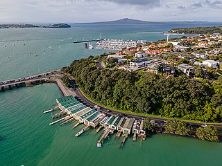
Ōrākei is a suburb of Auckland city, in the North Island of New Zealand. It is located on a peninsula five kilometres to the east of the city centre, on the shore of the Waitematā Harbour, which lies to the north, and Hobson Bay and Ōrākei Basin, two arms of the Waitematā, which lie to the west and south. To the east is the suburb of Mission Bay. Takaparawhau / Bastion Point is a coastal piece of land in Ōrākei. Between Takaparawhau and Paritai Drive is Ōkahu Bay and Reserve.

<span class="mw-page-title-main">Māngere</span> Suburb in Auckland, New Zealand

Māngere is a major suburb in South Auckland, New Zealand, located on mainly flat land on the northeastern shore of the Manukau Harbour, to the northwest of Manukau City Centre and 15 kilometres south of the Auckland city centre. It is the location of Auckland Airport, which lies close to the harbour's edge to the south of the suburb.

<span class="mw-page-title-main">Māngere Bridge (suburb)</span> Suburb of Auckland in New Zealand

Māngere Bridge is a suburb of Auckland, New Zealand, under the local governance of the Auckland Council. Surrounded by the Manukau Harbour, the area is the most north-western suburb of South Auckland, and is connected to Onehunga in central Auckland by three bridges that cross the Māngere Inlet. Many features of the Auckland volcanic field are found in and around Māngere Bridge, including Māngere Mountain, a 106-metre-high (348 ft) feature in the centre of the suburb, and Māngere Lagoon, a volcanic tidal lagoon opposite Puketutu Island in the harbour. The suburb is also home to Ambury Regional Park, a working farm and nature sanctuary run by Auckland Council, that connects to the Kiwi Esplanade and Watercare Coastal walkways.

<span class="mw-page-title-main">Chatswood, New Zealand</span> Suburb in Auckland, New Zealand

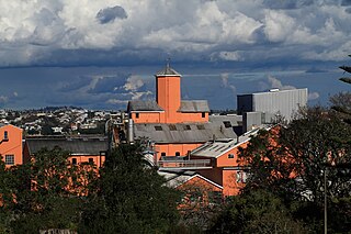
Chatswood is a suburb in the city of Auckland, New Zealand, in the middle-eastern side of North Shore. It contains a primary school and many parks. To the south of Chatswood is Kendall's Bay, a small bay of the Waitematā Harbour. The suburb is under the governance of Auckland Council. The Royal New Zealand Navy's Kauri Point Armament Depot is located in Chatswood. Chelsea Sugar Refinery is located in Chatswood.

<span class="mw-page-title-main">Hillsborough, Auckland</span> Suburb in Auckland, New Zealand

Hillsborough is a suburb of Auckland, New Zealand. It is under the local governance of the Auckland Council. Hillsborough is a leafy suburb of 20th-century houses. The area is serviced by two shopping areas; Onehunga and Three Kings. The area is served by secondary schools Mount Roskill Grammar School and Marcellin College.

<span class="mw-page-title-main">Kohimarama</span> Suburb in Auckland, New Zealand

Kohimarama is a coastal residential Auckland suburb, located to the east of the city. Kohimarama is situated between Mission Bay and St Heliers and has an accessible beach with a boardwalk and green recreational spaces located amongst residential areas. Local government of Kohimarama is the responsibility of the Ōrākei Local Board, which also includes the suburbs of Ōrākei, Mission Bay, St Heliers, Glendowie, St Johns, Meadowbank, Remuera and Ellerslie.

<span class="mw-page-title-main">Saint Heliers</span> Suburb in Auckland, New Zealand

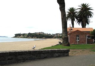
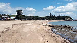
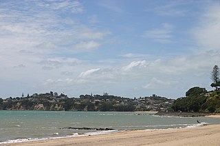
Saint Heliers is an affluent seaside suburb of Auckland with a population of 11,570 as of June 2023. This suburb is popular amongst visitors for the beaches, cafés, and views of Rangitoto Island, the distinctive volcanic island in the Hauraki Gulf.

<span class="mw-page-title-main">Bastion Point</span> Area of coastal land in Auckland, New Zealand

Takaparawhau / Bastion Point is a coastal piece of land in Ōrākei, Auckland, New Zealand, overlooking the Waitematā Harbour. The area is significant in New Zealand history as the site of protests in the late 1970s by Māori against forced land alienation by Pākehā. Takaparawhau is now the site of the private Ōrākei Marae, the public Michael Joseph Savage Memorial, and privately-owned reserve land that is accessible to the public.

<span class="mw-page-title-main">Auckland isthmus</span> Narrow landstrip in Auckland, New Zealand

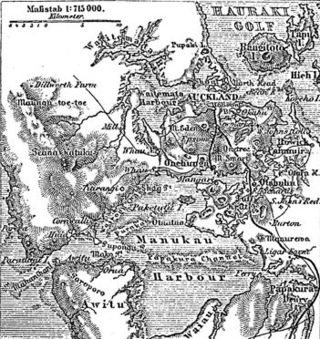
The Auckland isthmus, also known as the Tāmaki isthmus, is a narrow stretch of land on the North Island of New Zealand in the Auckland Region, and the location of the central suburbs of the city of Auckland, including the CBD. The isthmus is located between two rias : the Waitematā Harbour to the north, which opens to the Hauraki Gulf / Tīkapa Moana and Pacific Ocean, and the Manukau Harbour to the south, which opens to the Tasman Sea. The isthmus is the most southern section of the Northland Peninsula.

<span class="mw-page-title-main">History of Auckland</span> History of the city of Auckland, New Zealand

The human history of the Auckland metropolitan area stretches from early Māori settlers in the 14th century to the first European explorers in the late 18th century, over a short stretch as the official capital of (European-settled) New Zealand in the middle of the 19th century to its current position as the fastest-growing and commercially dominating metropolis of the country.

<span class="mw-page-title-main">St Paul's Church, Auckland</span> Church in Auckland, New Zealand

St Paul's Church is an historic Anglican church, located on Symonds Street near the University of Auckland and Auckland University of Technology, in the central business district of Auckland, New Zealand. The church is the longest established parish in the city and has one of the largest Anglican congregations in Australasia.

<span class="mw-page-title-main">Apihai Te Kawau</span> New Zealand Māori paramount chief (died 1869)

Apihai Te Kawau was a paramount chief of the Ngāti Whātua Māori iwi (tribe) of Auckland, New Zealand in the 19th century.

<span class="mw-page-title-main">Tamaki Drive</span> Road in New Zealand

Tamaki Drive is the coastal road which follows the contours of the Waitematā Harbour, Auckland, New Zealand. The road links the suburbs Ōrākei, Mission Bay, and Kohimarama ending in Saint Heliers providing easy access to the local beaches. Tamaki Drive was completed in 1932 and incorporates The Strand, Bice Esplanade and, what was once part of the old Kohimarama Road. It is also referred to as the Waterfront Road. Tamaki Drive is a flat road around 8 km long and popular with walkers, runners and roller skaters, and includes a dedicated cycle lane. Those travelling along Tamaki Drive can find scenic highlights and peaceful views across the harbour to the volcanic island Rangitoto. The cliffs backing onto Tamaki Drive are made of Waitematā Sandstone strata clothed in places with pōhutukawa. These trees seem to flower out of season, because these are actually Kermadec pōhutukawa with small distinctive roundish leaves.

<span class="mw-page-title-main">Ngāti Whātua Ōrākei</span> Māori iwi in New Zealand

Ngāti Whātua Ōrākei or Ngāti Whātua-o-Ōrākei is an Auckland-based Māori hapū (sub-tribe) in New Zealand. Together with Te Uri-o-Hau, Te Roroa and Te Taoū, it comprises the iwi (tribe) of Ngāti Whātua. These four hapū can act together or separately as independent tribes. The hapū's rohe is mostly in Tāmaki Makaurau, the site of present-day Auckland. Ngāti Whātua Ōrākei has around 6,000 members whose collective affairs are managed by the Ngāti Whātua Ōrākei Trust.

<span class="mw-page-title-main">Tāmaki Māori</span> Iwi in New Zealand

Tāmaki Māori are Māori iwi and hapū who have a strong connection to Tāmaki Makaurau, and whose rohe was traditionally within the region. Among Ngā Mana Whenua o Tāmaki Makaurau, also known as the Tāmaki Collective, there are thirteen iwi and hapū, organised into three rōpū (collectives), however Tāmaki Māori can also refer to subtribes and historical iwi not included in this list.

<span class="mw-page-title-main">Kepa Bush Reserve</span>

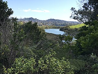
Kepa Bush Reserve is an ecological reserve on the Auckland isthmus in New Zealand, south of Mission Bay. It is situated near the smaller St John's Bush and is also known as the Pourewa Valley.

<span class="mw-page-title-main">Ōrākei (local board area)</span> Local board area in Auckland, New Zealand

Ōrākei is a local government area in Auckland, in New Zealand's Auckland Region. It is governed by the Ōrākei Local Board and Auckland Council. It currently aligns with the council's Ōrākei Ward.

Kiwi Tāmaki was a Māori warrior and paramount chief of the Waiohua confederation in Tāmaki Makaurau. The third generation paramount chief of Waiohua, Kiwi Tāmaki consolidated and extended Waiohua power over Tāmaki Makaurau, making it one of the most prosperous and populated areas of Aotearoa. Kiwi Tāmaki's seat of power was at Maungakiekie, which was the most elaborate pā complex in Aotearoa.

References

  1. 1 2 "ArcGIS Web Application". statsnz.maps.arcgis.com. Retrieved 16 November 2023.
  2. 1 2 "Population estimate tables - NZ.Stat". Statistics New Zealand . Retrieved 25 October 2023.
  3. 1 2 3 4 Elizabeth T. Jackson (1976). Delving Into The Past of Auckland’s Eastern Suburbs: Section 4 Mission bay, Section 5 Kohimarama. Auckland, N.Z.
  4. 1 2 "Statistical area 1 dataset for 2018 Census". Statistics New Zealand. March 2020. Mission Bay (141100). 2018 Census place summary: Mission Bay
  5. Lineham, Peter J. (13 July 2012). "'Missions and missionaries - Overseas missions'". Te Ara. Retrieved 2013-09-26.
  6. Keane, Basil (13 July 2012). "Kotahitanga – unity movements - Kotahitanga movements around the 1860s". Te Ara. Retrieved 2013-10-1.
  7. Te Ara the Encyclopedia of NZ. Tuarere, Paora p 1
  8. R. Walker. Struggle without End.p 113-114. Penguin, Auckland 2004. ISBN   0143019457
  9. 1 2 Zeff, Colin (2011). "Walsh Brothers Flying School". In La Roche, John (ed.). Evolving Auckland: The City's Engineering Heritage. Wily Publications. pp. 203–206. ISBN   9781927167038.
  10. 1 2 "Melanesian Mission Dining Hall" , Heritage New Zealand. Retrieved 2013-09-26.
  11. "Building successful town centres - Auckland Council" (PDF). aucklandcouncil.govt.nz. Auckland Council.
  12. "Eastridge - The Shops". eastridge.co.nz. Masfen Group.
  13. Boast, Richard (22 September 2012). "Story: Te tango whenua – Māori land alienation". Te Ara. Retrieved 2013-09-30.
  14. Gustafson, Barry (30 October 2012). "'Savage, Michael Joseph'". the Dictionary of New Zealand Biography . Te Ara. Retrieved 2013-09-26.
  15. Ministry for Culture & Heritage (10 May 2011). "Historic Graves and Monuments: The Savage Memorial". Ministry for Culture & Heritage. Retrieved 2013-09-26.
  16. Fox, Sue (30 July 2004). "Mission Bay's Historic Fountain To Flow Again". East and Bays Courier 2004, Auckland City Libraries. Retrieved 2013-27-09.
  17. Gray, Matthew (22 June 2010). "Dead ends the good life". Fairfax NZ news. Retrieved 2013-09-27.
  18. "Selwyn Reserve" Auckland Council. Retrieved 2013-09-27.
  19. "Mission Bay Events" Stuff. Retrieved 2013-09-27.
  20. "Kepa Bush Reserve", Auckland Council. Retrieved 2013-09-27.
  21. Dreaver, Anthony (1 September 2010). "Te Rangihiwinui, Te Keepa". Dictionary of New Zealand Biography . Te Ara . Retrieved 27 September 2013.