Moelwyn quarry

Last updated

Meolwyn
A crack in the Dam - geograph.org.uk - 1321414.jpg
The Moelwyn quarry, viewed from across Llyn Stwlan
Location
Gwynedd UK location map.svg
Schlaegel und Eisen nach DIN 21800.svg
Meolwyn quarry
Location in Gwynedd
Locationnear Blaenau Ffestiniog
County Gwynedd
Country Wales
Coordinates 52°58′28.4″N3°58′22.9″W / 52.974556°N 3.973028°W / 52.974556; -3.973028
grid reference SH6753143767
Production
Products Slate
Type Quarry
History
Opened1846 (1846)
The eastern slope of Moelwyn Bach showing the inclines to the Moelwyn Slate Quarry Moelwyn Bach viewed from Tan y Grisiau - geograph.org.uk - 36660.jpg
The eastern slope of Moelwyn Bach showing the inclines to the Moelwyn Slate Quarry

Moelwyn quarry is a defunct slate quarry located to the south of the village of Tanygrisiau, north Wales. Some initial prospecting was carried out in the 1820s and again in the 1840s, but it was 1860 before a company was formed, and chambers were excavated. The quarry was never a financial success, and operated sporadically until its demise in 1897. Despite the poor results, a spectacular series of seven inclines were constructed, to enable slates to reach the Ffestiniog Railway. The quarry was hampered by lack of a good water supply, and the mill was constructed between inclines 4 and 5, where water could be obtained from Llyn Stwlan. As in many quarries, barracks were provided, but these were occupied by whole families, living on the mountain, rather than used as lodgings for the quarrymen during the working week. Even in its remote location, there was still a concern for education, with basic literacy classes being run in the 1860s.

Contents

History

Between 1826 and 1828 the Rothschild's Royal Cambrian Company attempted to locate commercially viable slate deposits on land belonging to the Crown, on the eastern slopes of Moelwyn Bach. [1] Considerable effort was expended, as Nathan Meyer Rothschild employed John Rogers from Wrexham to construct a cart road, which wound its way up the side of the valley to reach the quarry. It was known as Ffordd yr luddew mawr ('road of the great Jew'), and was extended around the western flanks of Moelwyn Mawr in the 1850s to reach Pant Mawr quarry. [2] Several small-scale trial levels were cut, but none proved profitable, [3] and Rothschild withdrew in 1828. Attention then switched to the southern flanks of Moelwyn Mawr, where a lawyer from Ruthin called Humprhey Jones had opened a quarry by 1841, but activity at the site was very intermittent. [1]

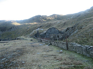
The next major advance was in 1860, when the Great Moelwyn Slate Company Ltd. was founded and paid £9,890 to buy the quarry from Thomas Cooper Smith. [1] Chambers were excavated underground, but as there was no reliable source of water to provide power, the mill was built at some distance from the workings, and at a lower level, so that a 40-by-4-foot (12.2 by 1.2 m) waterwheel could be fed from Llyn Stwlan. This drove six sawing tables and seven dressing machines. Three barrack buildings were erected, and whereas at most quarries, these were provided for the workers, at Moelwyn they were occupied by whole families, who lived there, rather than lodged there during the working week. The children had to make an arduous trek along the cart road to Tanygrisiau to attend school. [4] The slate quarries were known as places of learning and culture, with barracks at many quarries including reading rooms or libraries, which were regularly updated with Welsh language newspapers and magazines produced by the non-conformist denominational churches. Even in its remote location, Moelwyn was no exception, as basic literacy classes were taking place there in the 1860s when it was visited by Lord Palmerston. [5]

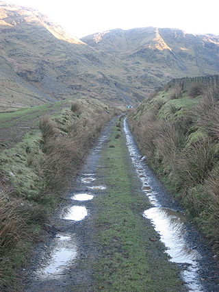
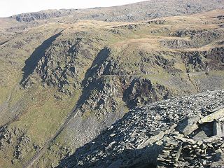
This period was also one of technological development, as Moelwyn was one of the first two quarries known to have used a water turbine, which was installed in 1864. The other was Ratgoed quarry, further south near Aberllefenni and served by the Corris Railway, which also installed a turbine in the same year. They did not become commonplace in the quarries until they were used to drive electrical generators, in the late 1890s and early 1900s. [6] The Great Moelwyn Slate Company Ltd was reconstituted in 1865, with a working capital of £50,000, and had five directors, four from London and one from Oxford. James Wright, also from London, was employed as engineer, and by 1866, the transport of slates by pack horse had been superseded by a spectacular series of seven inclines to descend some 1,100 feet (340 m) to reach the Ffestiniog Railway close to the northern end of the Moelwyn Tunnel. The quarry leased an area of 356 acres (144 ha), [1] and the mill buildings were located between the fourth and fifth inclines. [3]

The quarry was never a significant success. It was closed by 1869 according to J W Greaves, when he was giving evidence to a House of Commons enquiry for a Ffestiniog Railway bill. The lease and quarry plant were put up for auction in 1870, but failed to reach their reserve price, and so were re-auctioned in 1871. The plant was sold separately, and the lease was bought by Messrs Pemberton, Flavell and Allison, all from Birmingham, for £17,000. The sellers were listed as Messrs Clear and Cheffins from London, and James Wright, the engineer since 1865. In 1873, the lease was sold on to the Union Slate Co. Ltd., a company formed to operate the quarry with a working capital of £40,000. They employed Mr Arthur Wade to re-instate the tramways and machinery, and William Popham David was appointed as manager. 45 men were at work in 1874, but the project was short-lived, as the company was liquidated in 1875, and finally wound up in 1881. [7]

Again, the assets of the quarry were put up for auction, and the list included [8]

  • A tramway laid on inclines and levels, about 2,100 yards (1,900 m) long, with double track on the inclines and first four levels, and single track on the rest
  • 4 drums 6 by 11.75 feet (1.83 by 3.58 m) and 2 drums 5 by 11.75 feet (1.52 by 3.58 m) fitted with wire ropes and other equipment, including about 250 iron rollers
  • Machine sheds including 6 saw tables and 7 dressing machines
  • A powder magazine
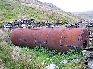
  • A 40 by 4 feet (12.2 by 1.2 m) breast-shot water wheel, with a conduit from the lake to supply it
  • A fully fitted out Carpenter's shop and Blacksmith's shop
  • 1 Patent saw-sharpener, 4 crowbars, 18 rock drills and 1 grindstone
  • 2 wheelbarrows, 6 lamps and 2 weighing machines

The final phase was from 1891 to 1897, when the quarry was run by J Solomon Jones, and traded as the Moelwyn Slate Company. There are few details of the amount of slate produced by the quarry, and the Department of Mines only has one set of annual returns for the entire life of the quarry. [7] Large scale Ordnance Survey maps of the area were published in 1889 and 1901, but both correspond to periods when the quarry was not in production, and so although the formation of the main tramway and inclines can be seen, and the location of the mill and its water wheel is evident, few other details can be gleaned from this source. [9]


In 1886 there was another attempt to work the vein even further down, when the Fron-Boeth quarry was opened. It was a continuation of the Pant-Mawr workings at a lower level, and the mill level was designated level 22, numbering downwards from level 1 at the top of Moelwyn. [10]

The site today

The quarry and the inclines remain largely intact, though Llyn Stwlan, which was extended in 1960 to become the upper reservoir in the Ffestiniog Power Station pumped-storage hydroelectricity scheme, sits just below the quarry and has obliterated the sixth incline, parts of the seventh, and much of the mill area. The Ffestiniog Railway's deviation around Llyn Ystradau, which is at a higher level to the original alignment, has also destroyed the lower section of the first incline. There are several adits accessible on the mountainside, but all have been fitted with metal grills to prevent entry. [4]

Geology

Description

Interconnections with other mines

The vein which Moelwyn worked continued dipping to the west, and the Pant-Mawr quarry worked it lower down. In order to prevent the collapse of the Moelwyn workings, the Pant-Mawr chambers were located beneath Moelwyn chambers, and there were some connections between the two quarries to ensure that this was the case. In addition, the Pant-Mawr chambers were numbered sequentially with those of the Moelwyn Quarry. Finished slates were initially transported to the Ffestiniog Railway at Penrhyndeudraeth by pack animals, using Moelwyn's traditional route, but subsequently, two inclines were built to connect to the Croesor Tramway. [11]

Bibliography

Related Research Articles

<span class="mw-page-title-main">Blaenau Ffestiniog</span> Town in Gwynedd, North Wales

Blaenau Ffestiniog is a town in Gwynedd, Wales. Once a slate mining centre in historic Merionethshire, it now relies much on tourists, drawn for instance to the Ffestiniog Railway and Llechwedd Slate Caverns. It reached a population of 12,000 at the peak development of the slate industry, but fell with the decline in demand for slate. The population of the community, including the nearby village Llan Ffestiniog, was 4,875 in the 2011 census: the fourth most populous in Gwynedd after Bangor, Caernarfon and Llandeiniolen. The population not including Llan is now only about 4,000.

<span class="mw-page-title-main">Tanygrisiau</span> Human settlement in Wales

Tanygrisiau is a village and area within Blaenau Ffestiniog in the upper end of the Vale of Ffestiniog in the county of Gwynedd, north-west Wales. It can be found along the southern side of the Moelwyn mountain range and dates to around 1750. It joins onto the semi-urban area of Blaenau Ffestiniog, and is in the community of Ffestiniog; located between 650 feet (200 m) and 750 feet (230 m) above sea level. it is in the electoral ward of Bowydd and Rhiw which had a 2011 census population of 1878. The village itself has a population of around 350.

<span class="mw-page-title-main">Croesor Tramway</span>

<span class="mw-page-title-main">Moelwyn Mawr</span>

Moelwyn Mawr is a mountain in Snowdonia, North Wales and forms part of the Moelwynion. Its summit overlooks the Vale of Ffestiniog and has views in all directions.

<span class="mw-page-title-main">Ffestiniog Power Station</span> Dam in Ffestiniog, Gwynedd

The Ffestiniog Power Station is a 360-megawatt (MW) pumped-storage hydroelectricity scheme near Ffestiniog, in Gwynedd, north-west Wales. The power station at the lower reservoir has four water turbines, which can generate at full capacity within 60 seconds of the need arising. The scheme has a storage capacity of around 1.44 GWh (5.2 TJ) at maximum output for four hours, and the capacity to power the whole of North Wales for several hours.

<span class="mw-page-title-main">Rhiwbach Tramway</span>

The Rhiwbach Tramway was a Welsh industrial, 1 ft 11+12 in narrow gauge railway connecting the remote slate quarries east of Blaenau Ffestiniog with the Ffestiniog Railway. It was in use by 1862, and remained so until progressively closed between 1956 and 1976. The route included three inclines, one of which became the last operational gravity incline in the North Wales slate industry. The tramway was worked by horses and gravity for much of its existence, but a diesel locomotive was used to haul wagons on the top section between 1953 and its closure in 1961.

<span class="mw-page-title-main">Croesor quarry</span> Disused slate mine in North Wales

Croesor quarry is a large underground slate mine in North Wales which was served by Croesor Tramway. Small scale quarrying began in the 1846, and by 1861, there were two companies in operation. They amalgamated in 1865, a year after the quarry was connected to the newly opened Croesor Tramway. Much money was invested in development work, but volumes of useful slate produced were small, amounting to just 226 tons in 1868. Access to the underground workings was by a single adit, and the surface mill was powered by two water wheels. A change of ownership in 1875 did little to improve the profitability of the quarry, and it closed in 1878 or 1882.

<span class="mw-page-title-main">Rhosydd quarry</span> Disused slate mine in North Wales

Rhosydd quarry was a slate quarry in the Moelwyn mountains, northeast of Porthmadog in North Wales.

<span class="mw-page-title-main">Cwt y Bugail quarry</span> Former slate quarry in north Wales

The Cwt y Bugail quarry is a former slate quarry located east of Blaenau Ffestiniog in Wales. It was first worked as a trial pit around 1840. Continuous production began in 1863 and continued until closure in 1961. The quarry was connected to the Ffestiniog Railway at Duffws Station via the Rhiwbach Tramway.

<span class="mw-page-title-main">Blaen y Cwm quarry</span> Disused Welsh slate quarry in Blaenau Ffestiniog

The Blaen y Cwm quarry was a slate quarry located east of Blaenau Ffestiniog in Wales. It was first worked in some time between 1813 and 1818 and sporadically after that until 1914. The quarry was connected to the Ffestiniog Railway at Duffws Station via the Rhiwbach Tramway.

<span class="mw-page-title-main">Conglog quarry</span> Former slate quarry in Wales

Conglog quarry was a small enterprise situated to the north-west of Tanygrisiau, near Blaenau Ffestiniog in Wales. It was overshadowed by the much bigger Rhosydd quarry a little further to the west. It was active from 1854 to 1910, and was operated by an individual, two partnerships and four separate companies over this period.

<span class="mw-page-title-main">Rhiwbach quarry</span> Disused slate quarry in North Wales

Rhiwbach quarry was a slate quarry located to the east of Blaenau Ffestiniog in North Wales. The quarry was a remote site; it was nearly 4 miles (6.4 km) to north-east of Duffws, the Festiniog Railway's terminus in Blaenau Ffestiniog. It was the connected to the Ffestiniog Railway by the Rhiwbach Tramway. Commercial operation began around 1812, and it finally closed in 1952. It was the last Welsh slate quarry where workers lived in barracks on the site. 'Rhiwbach' is Welsh for 'Little Hill'.

<span class="mw-page-title-main">Cwmorthin quarry</span> Disused slate quarry in North Wales

Cwmorthin quarry was a slate quarry west of the village of Tanygrisiau, north Wales. Quarrying on the site started in 1810. In 1860 it was connected to the Ffestiniog Railway. In 1900 it was acquired by the nearby Oakeley quarry and the two were connected underground. In 1970 it closed along with Oakeley. There was small-scale working in the 1980s and 1990s, and the mine finally closed in 1997.

<span class="mw-page-title-main">Graig Ddu quarry</span> Disused slate quarry in north Wales

Graig Ddu quarry is a disused slate quarry near Blaenau Ffestiniog, in Gwynedd, North Wales. Although output was only about 3,000 tons a year, it reputedly has 36 saw tables and the same number of dressing machines on site. As with others in the area, the quarry suffered from a lack of water, resulting in the siting of the mill some distance away, at a lower level.

<span class="mw-page-title-main">Wrysgan quarry</span> Disused slate quarry in North Wales

Wrysgan quarry was a slate quarry near the village of Tanygrisiau, Blaenau Festiniog, North Wales. It was worked intermittently from the 1830s, and was worked continuously from c.1850 until 1946. Wrysgan was an underground slate quarry, which was located on a small inaccessible site, some 1,390 feet (420 m) above sea level, to the west of Cwmorthin.

The Cwmorthin Tramway was a 1 ft 11+12 in industrial tramway in North Wales, which connected the Ffestiniog Railway to the Cwmorthin Quarry and later the Conglog Slate Quarry. It was built in the 1840s or 1850s, rising through two inclined planes to reach the main Cwmorthin Quarry mill and its internal incline which rose from floor 1 to floor 8. In 1874, it was extended, rising up through a third incline to the Cwmorthin Lake level and continuing along the valley floor to reach the Conglog Quarry. The tracks to Conglog were abandoned in the 1920s and the rest of the tramway ceased to be used from the onset of the Second World War.

<span class="mw-page-title-main">Parc quarry</span> Disused slate mine in North Wales

Parc Quarry was a compact underground slate quarry in the Croesor Valley, Gwynedd, North Wales. It was connected to the Croesor Tramway, which ran through the valley. The quarry concentrated on producing specialist slate products, rather than roofing slates, and was managed for much of the time by the innovator Moses Kellow. It operated for about 50 years, from 1870 to 1920.

<span class="mw-page-title-main">Fron-Boeth and Pant Mawr quarries</span> Two quarries in north Wales

Fron-Boeth and Pant Mawr quarries were two closely related and interconnected quarries on the western slopes of Moelwyn Mawr in Gwynedd, North Wales. Pant Mawr operated from around 1850 to 1879, and was partly re-opened in 1886 when it was amalgamated with Fron-Boeth. Both quarries closed during the First World War. Finished product was transported to the slate quays of Porthmadog by the Croesor Tramway.

<span class="mw-page-title-main">Bwlch y Slaters quarry</span> Slate quarry in north Wales

Bwlch y Slaters quarry is a slate quarry near Blaenau Ffestiniog, in Gwynedd, North Wales.

References

  1. 1 2 3 4 Boyd 1975, p. 456.
  2. Gwyn 2015, pp. 212, 217.
  3. 1 2 "Moelwyn Slate Mine (40599)". Coflein. RCAHMW.
  4. 1 2 Richards 1999, p. 165.
  5. Gwyn 2015, p. 195.
  6. Gwyn 2015, p. 122.
  7. 1 2 Boyd 1975, p. 457.
  8. Lindsay 1974, pp. 152–153.
  9. Moelwyn Quarry (Map). 1:2500. Ordnance Survey. 1889.
  10. Richards 1999, p. 140.
  11. Richards 1999, p. 144.