History
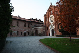
A distinct rural settlement in Monluè is reported at least since the Middle Ages; it was originally called Mons Luparium (in Latin, meaning "mountain - or hill - of the wolves"). This toponymy suggests that, back then, the area was probably more hilly than it is today, and that the forests between Monluè and Milan used to be infested by wolves. [1] Despite the inhospitable environment, friars from the Humiliati religious order founded an abbey in Monluè in the 13th century. They reclaimed the land, and a small rural town gradually developed in the surroundings of the abbey. [1]
The Humiliati were an Italian religious order of men formed probably in the 12th century. It was suppressed by a Papal bull in 1571 though an associated order of women continued into the 20th century.

An abbey is a complex of buildings used by members of a religious order under the governance of an abbot or abbess. It provides a place for religious activities, work, and housing of Christian monks and nuns.
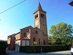
When the Humiliati religious order was suppressed in 1571, all their belongings were confiscated by the Jesuits, who adapted the abbey as a farmhouse. The church was modified in 1584 and restored in 1877. In the early 20th century, the Monluè complex was ceded to the Pio Albergo Trivulzio (a humanitarian Milanese institution). The ex abbey (now Cascina Monluè) is now owned by the city of Milan; the church of Saint Lawrence is still consecrated and in use.
The Pio Albergo Trivulzio, formally Azienda di servizi alla persona Istituti Milanesi Martinitt e Stelline e Pio Albergo Trivulzio, commonly referred to as Baggina, is an ancient retirement home and hospital in Milan. Still active today, it dates back to 1766.
As a difference with other border districts of Milan, such as Ponte Lambro to the south, Monluè has never experienced a true industrialization process; on the other hand, agricultural activities in the area have been gradually dismissed, so that the population has been decreasing rather than increasing over time, an unusual trend in the Milanese area.

Ponte Lambro is a comune (municipality) in the Province of Como in the Italian region Lombardy, located about 40 kilometres (25 mi) north of Milan and about 12 kilometres (7 mi) east of Como.

Gorgonzola is an Italian town of c. 20,000 inhabitants in the Metropolitan City of Milan, Lombardy. It is part of the territory of the Martesana, north-east of Milan.
John of Meda, Ord.Hum., also known as John of Como, was an Italian monk of the Humiliati Order and abbot at their monasteries at Milan and Como. He has been declared a saint by the Roman Catholic Church.

The Abbey of Santa Maria di Rovegnano is a Cistercian monastic complex in the comune of Milan, Lombardy, northern Italy. The borgo that has developed round the abbey was once an independent commune called Chiaravalle Milanese, now included in Milan and referred to as the Chiaravalle district.
Greco is a district ("quartiere") of Milan, Italy, part of the Zone 2 administrative division, located north-east of the city centre. Before being annexed to the city of Milan it was an independent comune, named Greco Milanese. As "Greco" is the Italian word for Greek, it has been suggested that the name refer to an old Greek settlement in the area; nevertheless, scholars tend to believe that the place was actually named after the Greco family that used to live here.
Taliedo is a peripheral district ("quartiere") of the city Milan, Italy, part of the Zone 4 administrative division, located south-east of the city centre. The informal boundaries of the district are three main city streets, respectively Via Mecenate, Via Bonfadini and Via Salomone.

Nosedo is a district ("quartiere") of the city of Milan, Italy. It is part of the Zone 4 administrative division, located south of the city centre. Until 1870, it was an autonomous comune. The name comes from the Latin nocetum, meaning "walnut forest", as walnut trees used to be common in the area.
Barona is a border district ("quartiere") of the city of Milan, Italy. It is part of the Zone 6 administrative division, and it is located south of the city centre. Its population can be roughly estimated to 85,000. It borders on the comunes of Buccinasco, Assago, and Corsico and the districts of Lorenteggio and Torretta. Its boundaries are marked by the Parco Agricolo Sud Milano nature reserve to the south, by the Naviglio Grande and Naviglio Pavese canals to the east and to the west, and by the Circonvallazione ring road to the north.
Ronchetto sul Naviglio is a district ("quartiere") of Milan, Italy, part of the Zone 6 administrative division of the city. Before being annexed to Milan, it has been an autonomous comune until 1870, and a frazione of Buccinasco between 1870 and 1923.

Giambellino and Lorenteggio are two historical and populous residential blocks of Milan, Italy. Together, they form a district ("quartiere") which is variously called "Giambellino", "Lorenteggio", Giambellino-Lorenteggio or Lorenteggio-Giambellino; the district is part of the Zone 6 administrative division of Milan.
Baggio is a district (quartiere) of Milan, Italy, part of the Zone 7 administrative division of the city. Before being annexed to Milan in 1923, it was an autonomous comune.
Assiano is a rural district ("quartiere") of Milan, Italy, part of the Zone 7 administrative division. It is a border district, at the western end of the city area. Before being annexed to Milan, it was an autonomous comune, except for a brief period (1808-1816) when it was included in Cusago.
Muggiano is a district (quartiere) of Milan, Italy, part of the Zone 7 administrative division of the city. It is located in western periphery, bordering on the comunes of Cesano Boscone, Cusago, Settimo Milanese, and Trezzano sul Naviglio. Before being annexed to Baggio, which in turn was annexed to Milan, Muggiano used to an autonomous comune.
Ghisolfa is a district ("quartiere") of Milan, Italy, part of the Zone 8 administrative division of the city, located north-west of the city centre. It is named after the "Ghisolfa Bridge" overpass, part of the external Circonvallazione ring road enclosing the centre of Milan. In turn, the bridge was named after two cascine, "Cascina Ghisolfa" and "Cascina Ghisolfetta", that existed in the area before the urbanization of the mid 20th century. The bridge was completed in 1941, prolonged in the 1960s, and enlarged in the 1990s.
Trenno is a district ("quartiere") of Milan, Italy, part of the Zone 8 administrative division of the city. It borders on green areas to the north and west and to the south ; to the east, it is adjacent to the Gallaratese district. Before being annexed to Milan, in 1923, it was an autonomous comune.
The Abbey of Viboldone is an abbey in Viboldone, a frazione of San Giuliano Milanese, in the province of Milan, northern Italy.
Corpi Santi di Milano is a former Italian comune, established in 1782 and annexed to Milan in 1873. It comprised the rural territory around the city walls of Milan. It was originally known just as Corpi Santi; "di Milano" was added in 1859, possibly to avoid confusion with the comune with the same name located in the area of Pavia.

The Oratorio di San Protaso is a church in via Lorenteggio, Milan, Lombardy.
Cascina Torchiera is a historic 'cascina a corte' (farmhouse) of Milan, Italy, dating back to the first half of the 14th century. It is located in Zone 8, adjacent to the Maggiore cemetery, in the Musocco/Garegnano district, and qualifies as one of the oldest surviving cascine within the city boundaries. The cascina is formally the property of the Comune di Milano city administration, but has become a squatted social center since the 1990s.

Saint Ambrose is a small church which is an annex to the farmhouse that takes its name from it, in Brugherio, Italy.

Cascina Sant'Ambrogio is the oldest between the farmhouses in Brugherio, Italy. It is annexed to Saint Ambrose Church from which it takes its name.