Monument, New Mexico | |
|---|---|
 Monument  Monument | |
| Coordinates: 32°37′27″N103°16′40″W / 32.62417°N 103.27778°W [1] | |
| Country | United States |
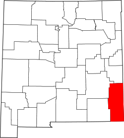
| State | New Mexico |
| County | Lea |
| Area | |
• Total | 5.28 sq mi (13.67 km2) |
| • Land | 5.28 sq mi (13.67 km2) |
| • Water | 0 sq mi (0.00 km2) |
| Elevation | 3,596 ft (1,096 m) |
| Population | |
• Total | 213 |
| • Density | 40.4/sq mi (15.58/km2) |
| Time zone | UTC-7 (Mountain (MST)) |
| • Summer (DST) | UTC-6 (MDT) |
| ZIP code | 88265 |
| Area code | 575 |
| GNIS feature ID | 2629120 [1] |
Monument is a census-designated place and unincorporated community in Lea County, New Mexico, United States. Its population was 206 as of the 2010 census. Monument has a post office with ZIP code 88265. [4] [5] State routes 8 and 322 intersect in the community. It was the first inhabited community in Lea County and was named after nearby Monument Spring. Jim Cook established the post office and a general store. [6]