Jal, New Mexico

Last updated

Jal, New Mexico
City
Motto: 
"The Enchantment Starts Here!"
Lea County New Mexico Incorporated and Unincorporated areas Jal Highlighted.svg
Location of Jal, New Mexico
Usa edcp location map.svg
Red pog.svg
Jal, New Mexico
Location in the United States
Coordinates: 32°06′53″N103°11′24″W / 32.11472°N 103.19000°W / 32.11472; -103.19000 [1]
Country United States
State New Mexico
County Lea
Area
[2]
  Total4.82 sq mi (12.49 km2)
  Land4.82 sq mi (12.49 km2)
  Water0.00 sq mi (0.00 km2)
Elevation
[1]
3,045 ft (928 m)
Population
 (2020) [3]
  Total2,202
  Density456.56/sq mi (176.28/km2)
Time zone UTC-7 (Mountain (MST))
  Summer (DST) UTC-6 (MDT)
ZIP code
88252
Area code 575
FIPS code 35-35040
GNIS feature ID2410131 [1]
Website www.cityofjal.us

Jal is a small city located in Lea County, New Mexico, United States. It is New Mexico's south-easternmost city, and shares a border with Texas to the east and south. The population was 2,047 at the 2010 census. [4] Jal is historically important in the natural gas industry, from the early 1900s to the present day. [5]

Contents

Geography

According to the United States Census Bureau, the city has a total area of 4.8 square miles (12 km2), all land.

Demographics

Historical population
CensusPop.Note
1930 404
1940 1,157186.4%
1950 2,04776.9%
1960 3,05149.0%
1970 2,602−14.7%
1980 2,6752.8%
1990 2,156−19.4%
2000 1,996−7.4%
2010 2,0472.6%
2020 2,2027.6%
U.S. Decennial Census [6] [3]

As of the census [7] of 2010, there were 2,047 people, with 788 occupied houses. The population density was 426.5 inhabitants per square mile (164.7/km2). There were 1009 housing units at an average density of 210.2 per square mile (81.2/km2). The racial makeup of the city was 84.81% White, 0.83% African American, 0.73% Native American, 11.82% from other races, and 1.66% from two or more races. Hispanic or Latino of any race were 48.12% of the population.

There were 788 households, out of which 34.1% had children under the age of 18 living with them, 56.5% were married couples living together, 11.4% had a female householder with no husband present, and 25.5% were non-families. 23.2% of all households were made up of individuals, and 9.5% had someone living alone who was 65 years of age or older. The average household size was 2.60 and the average family size was 3.04.

In the city, the population was spread out, with 29.5% under the age of 19, 12.2% in their 20s, 10.1% in their 30s, 12.6% in their 40s, 13.2% in their 50s, and 22.4% who were 60 years of age or older. The median age was 38.2 years. For every 100 females, there were 99.5 males. For every 100 females age 18 and over, there were 97.1 males.

The median income for a household in the city was $39,813, and the median income for a family was $51,538. Males had a median income of $46,250 versus $30,147 for females. The per capita income for the city was $20,597. About 12.0% of families and 14.4% of the population were below the poverty line, including 23.6% of those under age 18 and 18.5% of those age 65 or over.

History

During the early 1800s, the Cowden boys of Midland, Texas moved the entire John A. Lynch herd to the Monument draw, about 6 miles northeast of present-day Jal. All the cattle were branded with the JAL brand from shoulder to hip. In the process of trying to rebrand the Cowdens, they found it too big a task so they registered the brand under their name in Silver City, New Mexico Territory. [8]

In 1913, Charles Justis (a merchant) applied for a post office under the name "Jal" to open six miles east of the city of Jal. However, in 1916, Jal became drought-stricken and the store and post office were relocated to Muleshoe Wells and the city of Jal was established in its present location. [8]

On November 1, 1927, Texas Co. brought in the first well, the Rhodes #1. Then on June 2, 1928, a second well, serving up more than 90 million cubic feet of gas a day, was brought online 6 miles west of Jal. This created a “boom town,” with all the prosperity and problems that go with it. The Great Depression and low crude prices caused a sharp slump in drilling and people left in droves. Jal almost became a ghost town overnight.[ citation needed ]

In the summer of 1934, the Cooper #1 brought the “Big Boom” back to Jal. By then Jal had a passenger train and its population rose to around 500. Housing was in short supply and ranchers opened their homes to “roughnecks”. New businesses sprang up, and with the gas gathering system by El Paso Natural Gas, prosperity continued.[ citation needed ]

Government

In 1950, a city hall was built. In 1966, it received a renovation, and in 1987, it received another one. By 2019, the municipal authorities considered the 1950 building out of date, so that year they authorized a renovation of the 37,900-square-foot (3,520 m2) former Burke Junior High School, with city hall in a 14,300-square-foot (1,330 m2) eastern portion. This was under construction in 2021. [9]

Education

It is within Jal Public Schools. [10]

Infrastructure

Highways

Railroad

The Texas & New Mexico Railway provides freight service.

Airport

The city is served by the Lea County/Jal Airport about three miles to the northeast. The airport has a paved, 4700 ft. runway. Jal once saw commuter airline service in 1964 by Solar Airlines. [11]

Climate

Jal experiences a cool semi-arid climate, typical of the high plains of eastern New Mexico. However, it borders a hot semi-arid climate.

Climate data for Jal, New Mexico.
MonthJanFebMarAprMayJunJulAugSepOctNovDecYear
Record high °F (°C)85
(29)
89
(32)
98
(37)
102
(39)
107
(42)
114
(46)
112
(44)
110
(43)
108
(42)
100
(38)
89
(32)
84
(29)
114
(46)
Mean daily maximum °F (°C)59.9
(15.5)
65.2
(18.4)
72.9
(22.7)
81.8
(27.7)
89.0
(31.7)
95.6
(35.3)
96.3
(35.7)
95.0
(35.0)
88.8
(31.6)
80.3
(26.8)
68.6
(20.3)
61.0
(16.1)
79.5
(26.4)
Mean daily minimum °F (°C)27.9
(−2.3)
32.4
(0.2)
38.8
(3.8)
47.6
(8.7)
56.8
(13.8)
65.3
(18.5)
68.0
(20.0)
66.8
(19.3)
60.2
(15.7)
48.9
(9.4)
36.7
(2.6)
29.2
(−1.6)
48.2
(9.0)
Record low °F (°C)−11
(−24)
−8
(−22)
10
(−12)
20
(−7)
28
(−2)
40
(4)
50
(10)
50
(10)
37
(3)
20
(−7)
8
(−13)
0
(−18)
−11
(−24)
Average precipitation inches (mm)0.41
(10)
0.48
(12)
0.42
(11)
0.63
(16)
1.42
(36)
1.28
(33)
1.82
(46)
1.79
(45)
2.08
(53)
1.31
(33)
0.47
(12)
0.46
(12)
12.58
(320)
Average snowfall inches (cm)1.3
(3.3)
0.7
(1.8)
0.3
(0.76)
0
(0)
0
(0)
0
(0)
0
(0)
0
(0)
0
(0)
0
(0)
0.6
(1.5)
0.8
(2.0)
3.5
(8.9)
Source: The Western Regional Climate Center [12]

Notable people

Related Research Articles

<span class="mw-page-title-main">Sierra County, New Mexico</span> County in New Mexico, United States

Sierra County is a county located in the U.S. state of New Mexico. As of the 2020 Census, the population was 11,576. Its county seat is Truth or Consequences.

<span class="mw-page-title-main">Roosevelt County, New Mexico</span> County in New Mexico, United States

Roosevelt County is a county located in the U.S. state of New Mexico. As of the 2020 census, the population was 19,191. Its county seat is Portales. The county was created in 1903 from Chaves and Guadalupe counties and named for the then-current President of the United States, Theodore Roosevelt. The county's eastern border is the Texas state line.

<span class="mw-page-title-main">Quay County, New Mexico</span> County in New Mexico, United States

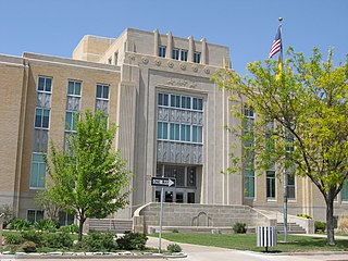
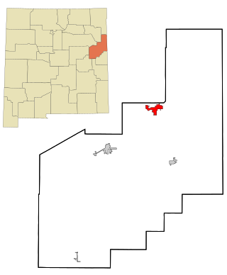
Quay County is a county in the state of New Mexico. As of the 2020 U.S. census, the population was 8,746. Its county seat is Tucumcari. The county was named for Pennsylvania senator Matthew Quay, who supported statehood for New Mexico. Its eastern border is the Texas state line, approximately 103.04 degrees west longitude.

<span class="mw-page-title-main">Otero County, New Mexico</span> County in New Mexico, United States

Otero County is a county located in the U.S. state of New Mexico. As of the 2020 census, the population was 67,839. Its county seat is Alamogordo. Its southern boundary is the Texas state line. It is named for Miguel Antonio Otero, the territorial governor when the county was created.

<span class="mw-page-title-main">Luna County, New Mexico</span> County in New Mexico, United States

Luna County(Spanish: Condado de Luna) is a county located in the U.S. state of New Mexico. As of the 2020 census, the population was 25,427. Its county seat is Deming. This county abuts the Mexican border. Luna County comprises the Deming, NM Micropolitan Statistical Area.

<span class="mw-page-title-main">Lincoln County, New Mexico</span> County in New Mexico, United States

Lincoln County is a county in the U.S. state of New Mexico. As of the 2020 census, the population was 20,269. Its county seat is Carrizozo, while its largest community is Ruidoso.

<span class="mw-page-title-main">Lea County, New Mexico</span> County in New Mexico, United States

Lea County is a county located in the U.S. state of New Mexico. As of the 2020 census, its population was 74,455.

<span class="mw-page-title-main">Eddy County, New Mexico</span> County in New Mexico, United States

Eddy County is a county located in the U.S. state of New Mexico. As of the 2020 census, the population was 62,314. Its county seat and largest city is Carlsbad. The county was created in 1891 and later organized in 1892. It is north of the Texas state line.

<span class="mw-page-title-main">Chaves County, New Mexico</span> County in New Mexico, United States

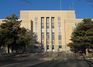
Chaves County is a county in New Mexico, United States. As of the 2020 census, the population was 65,157. Its county seat is Roswell. Chaves County was named for Colonel Jose Francisco Chaves, a military leader there during the Civil War and later in Navajo campaigns. The county was created by the New Mexico Territorial Legislature on February 25, 1889, out of land from Lincoln County.

<span class="mw-page-title-main">Bernalillo County, New Mexico</span> County in New Mexico, United States

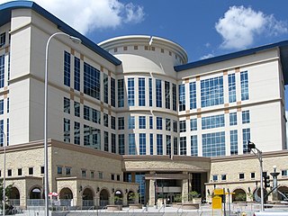
Bernalillo County is the most populous county in the U.S. state of New Mexico. As of the 2020 census, the population was 676,444. The county seat, Albuquerque, is the most populous city in New Mexico.

<span class="mw-page-title-main">Texico, New Mexico</span> City in New Mexico, United States

Texico is a city in Curry County, New Mexico, United States. Its population was 1,130 at the 2010 census. The city is located on the Texas-New Mexico border with the town of Farwell across the border.

<span class="mw-page-title-main">Fort Sumner, New Mexico</span> Village and county seat in De Baca County, New Mexico, United States

Fort Sumner is a village in and the county seat of De Baca County, New Mexico, United States. The population was 1,031 at the 2010 U.S. Census, down from the figure of 1,249 recorded in 2000. Fort Sumner is the spring and fall home of the Columbia Scientific Balloon Facility, and is home to the burial site of famed outlaw of the American West, Billy the Kid, who was shot and killed there in 1881.

<span class="mw-page-title-main">Chaparral, New Mexico</span> Census-designated place in New Mexico, United States

Chaparral is an unincorporated community and census-designated place (CDP) in Doña Ana and Otero counties, New Mexico. The population was 14,631 at the 2010 census. Chaparral is primarily a bedroom community for the neighboring city of El Paso, Texas, and the neighboring military installations of White Sands Missile Range and Fort Bliss. It is officially part of the Las Cruces Metropolitan Statistical Area.

<span class="mw-page-title-main">Eunice, New Mexico</span> City in New Mexico, United States

Eunice is a city in Lea County, New Mexico, United States. The population was 2,922 at the 2010 census.

<span class="mw-page-title-main">Hobbs, New Mexico</span> City in New Mexico, United States

Hobbs is a city in Lea County, New Mexico, United States. Its population was 40,508 at the 2020 census, increasing from 34,122 in 2010.

<span class="mw-page-title-main">Lovington, New Mexico</span> City in New Mexico, United States

Lovington is a city in, and the county seat of, Lea County, New Mexico, United States. The population was 11,009 at the 2010 census, up from 9,471 in 2000.

<span class="mw-page-title-main">Tatum, New Mexico</span> Town in New Mexico, United States

Tatum is a town in Lea County, New Mexico, United States. The population was 798 at the 2010 census, up from 683 in 2000.

<span class="mw-page-title-main">Logan, New Mexico</span> Village in New Mexico, United States

Logan is a village in Quay County, New Mexico, United States. The population was 1,042 at the 2010 census.

<span class="mw-page-title-main">Socorro, New Mexico</span> City in New Mexico, United States

Socorro is a city in Socorro County in the U.S. state of New Mexico. It is in the Rio Grande Valley at an elevation of 4,579 feet (1,396 m). In 2010 the population was 9,051. It is the county seat of Socorro County. Socorro is located 74 miles (119 km) south of Albuquerque and 146 miles (235 km) north of Las Cruces.

<span class="mw-page-title-main">Doña Ana County, New Mexico</span> County in New Mexico, United States

Doña Ana County is located in the southern part of the State of New Mexico, United States. As of the 2020 U.S. Census, its population was 219,561, which makes it the second-most populated county in New Mexico. Its county seat is Las Cruces, the second-most populous municipality in New Mexico after Albuquerque, with 111,385 as of the 2020 U.S. Census.

References

  1. 1 2 3 U.S. Geological Survey Geographic Names Information System: Jal, New Mexico
  2. "ArcGIS REST Services Directory". United States Census Bureau. Retrieved October 12, 2022.
  3. 1 2 "Census Population API". United States Census Bureau. Retrieved October 12, 2022.
  4. "2010.census.gov". Archived from the original on July 1, 2012. Retrieved March 23, 2012.
  5. "JAL Ranch spawned New Mexico community, natural gas industry". Odessa American. Retrieved October 26, 2020.
  6. "Census of Population and Housing". Census.gov. Retrieved June 4, 2015.
  7. factfinder2.census.gov
  8. 1 2 "The City of Jal, New Mexico". www.cityofjal.us. Retrieved October 26, 2020.
  9. "Work on new Jal City Hall underway". Hobbs News . June 24, 2021. Retrieved July 14, 2022.
  10. "2020 CENSUS - SCHOOL DISTRICT REFERENCE MAP: Lea County, NM" (PDF). U.S. Census Bureau . Retrieved July 14, 2022.
  11. Solar Airlines Inc. August 1, 1964 flight schedule
  12. "Seasonal Temperature and Precipitation Information". Western Regional Climate Center. Retrieved August 13, 2013.
  13. Kathy Whitworth named female athlete of the year