Nadine, New Mexico | |
---|---|
Coordinates: 32°37′23″N103°06′28″W / 32.62306°N 103.10778°W [1] | |
Country | United States |
State | New Mexico |
County | Lea |
Area | |
• Total | 11.40 sq mi (29.52 km2) |
• Land | 11.39 sq mi (29.51 km2) |
• Water | 0.01 sq mi (0.01 km2) |
Elevation | 3,583 ft (1,092 m) |
Population | |
• Total | 477 |
• Density | 41.87/sq mi (16.17/km2) |
Time zone | UTC-7 (Mountain (MST)) |
• Summer (DST) | UTC-6 (MDT) |
Area code | 575 |
GNIS feature ID | 2584159 [1] |
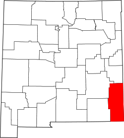
Nadine is an unincorporated community and census-designated place in Lea County, New Mexico, United States. Its population was 376 as of the 2010 census. [4] New Mexico State Road 18 passes through the community.
According to the U.S. Census Bureau, the community has an area of 11.4 square miles (29.4 km2), of which 0.004 square miles (0.01 km2), or 0.05%, are water. [5]
Census | Pop. | Note | %± |
---|---|---|---|
2010 | 376 | — | |
2020 | 477 | 26.9% | |
U.S. Decennial Census [6] [3] |
It is in Hobbs Public Schools. [7] Hobbs High School is the zoned comprehensive high school.
Eunice is a city in Lea County, New Mexico, United States. The population was 2,922 at the 2010 census.
Hobbs is a city in Lea County, New Mexico, United States. Its population was 40,508 at the 2020 census, increasing from 34,122 in 2010.
Lovington is a city in, and the county seat of, Lea County, New Mexico, United States. The population was 11,009 at the 2010 census, up from 9,471 in 2000.
Tatum is a town in Lea County, New Mexico, United States. The population was 798 at the 2010 census, up from 683 in 2000.
Escudilla Bonita is a census-designated place in Catron County, New Mexico, United States. Its population was 119 as of the 2010 census.
Homestead is a census-designated place in Catron County, New Mexico, United States. Its population was 47 as of the 2010 census.
Rancho Grande is a census-designated place in Catron County, New Mexico, United States. Its population was 142 as of the 2010 census. The community is located along U.S. Route 180.
Happy Valley is an unincorporated community and census-designated place in Eddy County, New Mexico, United States. Its population was 519 as of the 2010 census. The community is located on the western edge of Carlsbad; New Mexico State Road 524 passes through the area. The town was settled as a farming community before potash was manufactured here. It was named because the lack of land use regulations made residents happy.
Cedar Hill is an unincorporated community and census-designated place in San Juan County, New Mexico, United States. Its population was 847 as of the 2010 census. The community is located on U.S. Route 550, near the Colorado border. Cedar Hill was originally known as Cox's Crossing. The name was chosen during a Literacy Society meeting by picking names out of a hat. A post office operated from 1892 to 1966.
Highland Meadows is a census-designated place in Valencia County, New Mexico, United States. Its population was 624 as of the 2010 census.
Pueblitos is a census-designated place in Valencia County, New Mexico, United States. Its population was 794 as of the 2010 census. New Mexico State Road 116 passes through the community.
North Hobbs is an unincorporated community and census-designated place in Lea County, New Mexico, United States. Its population was 5,391 as of the 2010 census.
Jacona is an unincorporated community and census-designated place in Santa Fe County, New Mexico, United States. Its population was 412 as of the 2010 census.
Canova is an unincorporated community and census-designated place in Rio Arriba County, New Mexico, United States. Its population was 118 as of the 2010 census. The community is located on the west bank of the Rio Grande. It is named after the extensive irrigation in the area, as it means "sluice" in Spanish.
Chamita is a census-designated place in Rio Arriba County, New Mexico, United States. Its population was 870 as of the 2010 census. New Mexico State Road 74 passes through the community. During its earlier years, the community was known as San Pedro De Chamita and served as the first county seat for Rio Arriba county.
Chili is an unincorporated community and census-designated place in Rio Arriba County, New Mexico. Its population was 654 as of the 2010 census. U.S. Route 84 passes through the community. The name comes from a station of the D&RG railroad that was known locally as the "Chili Line."
El Duende is an unincorporated community and census-designated place in Rio Arriba County, New Mexico, United States. Its population was 707 as of the 2010 census. The community is located at the junction of U.S. Routes 84/285 and New Mexico State Road 74. El Duende means "the dwarf" in Spanish, but how and why it adopted this moniker is unknown.
La Villita is an unincorporated community and census-designated place in Rio Arriba County, New Mexico, United States. Its population was 957 as of the 2010 census.
Los Luceros is an unincorporated community and census-designated place in Rio Arriba County, New Mexico, United States. Its population was 906 as of the 2010 census.