North Hobbs, New Mexico | |
|---|---|
 North Hobbs | |
| Coordinates: 32°46′23″N103°07′30″W / 32.77306°N 103.12500°W | |
| Country | United States |
| State | New Mexico |
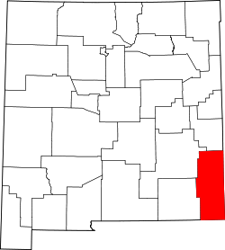
| County | Lea |
| Area | |
• Total | 26.08 sq mi (67.55 km2) |
| • Land | 26.04 sq mi (67.45 km2) |
| • Water | 0.039 sq mi (0.10 km2) |
| Elevation | 3,648 ft (1,112 m) |
| Population | |
• Total | 6,529 |
| • Density | 251/sq mi (96.8/km2) |
| Time zone | UTC-7 (Mountain (MST)) |
| • Summer (DST) | UTC-6 (MDT) |
| Area code | 575 |
| GNIS feature ID | 2630706 [2] |
North Hobbs is an unincorporated community and census-designated place in Lea County, New Mexico, United States. Its population was 5,391 as of the 2010 census. [4]