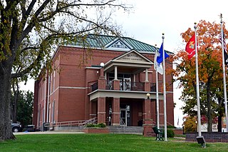
Benton County is a county located in the west central part of the U.S. state of Missouri. The population was 19,394 as of the 2020 Census. Its county seat is Warsaw. The county was organized January 3, 1835, and named for U.S. Senator Thomas Hart Benton of Missouri.

Benton County is a county within the Northwest Arkansas region with a culture, economy, and history that have transitioned from rural and agricultural to suburban and white collar since the growth of Walmart, which is headquartered in Benton County. Created as Arkansas's 35th county on September 30, 1836, Benton County contains thirteen incorporated municipalities, including Bentonville, the county seat, and Rogers, the most populous city. The county was named after Thomas Hart Benton, a U.S. Senator from Missouri influential in Arkansas statehood.

Benton is a city in Scott County, Missouri, United States. The population was 863 at the 2010 census. It is the county seat of Scott County.
Edwards is an unincorporated community in southeastern Benton County, Missouri, United States. It is located on Route 7, approximately 16 miles (26 km) southeast of Warsaw.
Santiago is an unincorporated community in Benton County, Missouri, United States. Santiago is located along Supplemental Route E, 7.1 miles (11.4 km) west-northwest of Lincoln.
Palo Pinto is an unincorporated community in Benton County, Missouri, United States. Palo Pinto is located 6.6 miles (10.6 km) west of Lincoln.
Zora or Old Zora is an unincorporated community in eastern Benton County, Missouri, United States. Zora is located on the Big Buffalo Creek arm of the Lake of the Ozarks, 15.8 miles (25.4 km) east-northeast of Warsaw.
Lakeview Heights is an unincorporated community in Benton County, Missouri, United States. Lakeview Heights is located on the Osage River, 12.3 miles (19.8 km) east of Warsaw.
Tackner is an unincorporated community in Benton County, Missouri, United States. Tackner is located on Missouri Route 7 near the Truman Reservoir, 2.7 miles (4.3 km) west of Warsaw.
Dell is an unincorporated community in Benton County, Missouri, United States. Dell is located 6.3 miles (10.1 km) southeast of Warsaw.
Bentonville is an unincorporated community in Benton County, Missouri, United States. Bentonville is located along Missouri Route 83, 10.5 miles (16.9 km) south-southwest of Warsaw.
Fristoe is an unincorporated community in Benton County, Missouri, United States. Fristoe is located at the junction of U.S. Route 65 and Supplemental Route CC, 10.45 miles (16.82 km) southeast of Warsaw.
Avery is an unincorporated community in Benton and Hickory counties, Missouri, United States. Avery is located on Supplemental Route B, 8.7 miles (14.0 km) north-northeast of Wheatland.
Hastain is an unincorporated community in Benton County, Missouri, United States. Hastain is located on Supplemental Route V, 11.5 miles (18.5 km) east-southeast of Warsaw.
Lively is an unincorporated community in Benton County, Missouri, United States. Lively is located on Knobby Creek, 15.1 miles (24.3 km) east of Warsaw.
Knobby is an unincorporated community in Benton County, Missouri, United States. Knobby is located along Supplemental Route DD, 16.8 miles (27.0 km) east-southeast of Warsaw.
Mount Hulda is an unincorporated community in Benton County, in the U.S. state of Missouri.
Passo is an extinct town in Benton County, in the U.S. state of Missouri. The GNIS classifies it as a populated place.
Sparta is an unincorporated community in Buchanan County, in the U.S. state of Missouri.
Sagrada is an unincorporated community in Camden County, in the U.S. state of Missouri. It is located in the far northwestern corner of the county, in Adair Township, just south of the Lake of the Ozarks.

