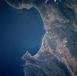
Monterey Bay is a bay of the Pacific Ocean located on the coast of the U.S. state of California. The bay is south of the major cities of San Francisco and San Jose. The county-seat city of Santa Cruz is located at the north end of the bay. The city of Monterey is on the Monterey Peninsula at the south end. The Monterey Bay Area is a local colloquialism sometimes used to describe the whole of the Central Coast communities of Santa Cruz and Monterey counties.

Moss Landing is a census-designated place (CDP) in Monterey County, California, United States. Moss Landing is located 15 miles (24 km) north-northeast of Monterey, at an elevation of 10 feet. It is located on the shore of Monterey Bay, at the mouth of Elkhorn Slough, and at the head of the submarine Monterey Canyon.

Pajaro is a census-designated place (CDP) in Monterey County, California, United States. Pajaro is located on the south bank of the Pajaro River 5 miles (8 km) northeast of its mouth, at an elevation of 26 feet. The population was 3,070 at the 2010 census, down from 3,384 at the 2000 census. The school district is in Santa Cruz County.

The Central Coast is an area of California, United States, roughly spanning the coastal region between Point Mugu and Monterey Bay. It lies northwest of Los Angeles County and south of San Francisco and San Mateo counties. Six counties make up the Central Coast: from south-to north, Ventura, Santa Barbara, San Luis Obispo, Monterey, San Benito, and Santa Cruz.
Zmudowski State Beach is located on Monterey Bay, in Moss Landing, Monterey County, northern California.

The Salinas River is the longest river of the central coast of California, running 175 miles (282 km) and draining 4,160 square miles. It flows north-northwest and drains the Salinas Valley that slices through the central California Coast Ranges south of Monterey Bay. The river begins in southern San Luis Obispo County, originating in the Los Machos Hills of the Los Padres National Forest. From there, the river flows north into Monterey County, eventually making its way to connect with the Monterey Bay, part of the Pacific Ocean, approximately 5 miles south of Moss Landing. The river is a wildlife corridor, and provides the principal source of water from its reservoirs and tributaries for the farms and vineyards of the valley.

The Moss Landing Marine Laboratories (MLML) is a multi-campus marine research consortium of the California State University System, headquartered at Moss Landing, California.
Moss is a small, soft, non-vascular plant that does not have flowers or seeds.
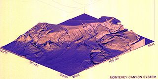
Monterey Canyon, or Monterey Submarine Canyon, is a submarine canyon in Monterey Bay, California with steep canyon walls measuring a full 1 mile in height from bottom to top, which height/depth rivals the depth of the Grand Canyon itself. It is the largest such submarine canyon along the West coast of the North American continent, and was formed by the underwater erosion process known as turbidity current erosion. Many questions remain unresolved regarding the exact nature of its origins, and as such it is the subject of several ongoing geological and marine life studies being carried out by scientists stationed at the nearby Monterey Bay Aquarium Research Institute, the Moss Landing Marine Laboratories, and other oceanographic institutions.

Area code 831 is a California telephone area code that was split from area code 408 on July 11, 1998.
Elkhorn Slough is a 7-mile-long (11 km) tidal slough and estuary on Monterey Bay in Monterey County, California. The community of Moss Landing and the Moss Landing Power Plant are located at the mouth of the slough on the bay.
Moss, California may refer to:

Notleys Landing is an uninhabited former community in the Big Sur region of Monterey County, California. It is located near the mouth of the Palo Colorado Canyon 11 miles (18 km) south of the Carmel River, at an elevation of 112 feet.

Pacific Grove Acres is an unincorporated community in Monterey County, California. It is located northwest of Pacific Grove, at an elevation of 125 feet.

Moss Landing State Beach is a state park on Monterey Bay, in Monterey County, California.

Salinas River State Beach is a beach at the river mouth of the Salinas River at Monterey Bay, in Monterey County, California.
Rancho Bolsa Nueva y Moro Cojo was a 30,901-acre (125.05 km2) Mexican land grant in present-day Monterey County, California given in 1844 by Governor Manuel Micheltorena to María Antonia Pico de Castro. Literally translated, the name means "new pocket and lame moor". In the plains of Argentina and Uruguay, "moro" is the color of a horse, a special gray-bluish shade. This name must certainly be of Spanish origin, so it is not unreasonable to suppose that this Spanish name of a place in California does not refer to a "moor" but to a lame horse. The name "pocket" refers to pockets of land surrounded by marshes. The grant extended from Moss Landing on the Monterey Bay inland to present day Prunedale, and south to Castroville.
Moss Landing Wildlife Area is a California State wildlife preserve on the shore of Elkhorn Slough.
Kakani Katija is a bioengineer from Hawaii. While earning her Master's and PhD in Aeronautics and Bioengineering, Katija began to study the mechanics of swimming and feeding marine organisms.


