
Ku-ring-gai Chase National Park is a national park on the northern side of Sydney in New South Wales, Australia. The 14,977-hectare (37,010-acre) park is 25 kilometres (16 mi) north of the Sydney central business district and generally comprises the land east of the M1 Pacific Motorway, south of the Hawkesbury River, west of Pittwater and north of Mona Vale Road. It includes Barrenjoey Headland on the eastern side of Pittwater.

Pymble is a suburb on the Upper North Shore of Sydney in the state of New South Wales, Australia. Pymble is 15 kilometres (9 mi) north of the Sydney central business district in the local government area of Ku-ring-gai Council.

Hornsby Shire is a local government area situated on the Upper North Shore as well as parts of the Hills District, of Sydney in the state of New South Wales, Australia. The shire stretches from the M2 Hills Motorway in the south to the Hawkesbury River town of Wisemans Ferry, some 53 kilometres (33 mi) to the north, making it the largest local government council in the Greater Sydney Metropolitan region by total area. As of the 2016 census the shire had an estimated population of 142,667.
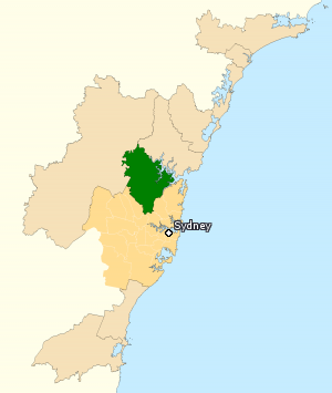
The Division of Berowra is an Australian electoral division in the state of New South Wales. The Division covers the northern parts of the Greater Sydney area with the local government areas of the Hornsby Shire and the Hills Shire.

Asquith is a suburb in Sydney's Northern Suburbs in the state of New South Wales, Australia. Asquith is located 26 km north-west of the Sydney central business district, in the local government area of Hornsby Shire. The suburb contains a section of Ku-ring-gai Chase National Park on its eastern side.

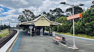
Berowra railway station is a heritage-listed railway station located on the Main Northern Line, serving the Sydney suburb of Berowra. It is served by Sydney Trains T1 North Shore Line services and NSW TrainLink Central Coast & Newcastle Line services.

Brooklyn is a suburb and the northern most town on the Pacific Highway in Sydney, New South Wales, Australia. Brooklyn is located on the northern outskirts of Sydney and is located in the local government area of the Hornsby Shire with a population of 737 as of the 2021 census. Brooklyn is surrounded by the Muogamarra Nature Reserve and occupies a strip of waterfront along the southern bank of the Hawkesbury River.

Berowra is an outer suburb of Northern Sydney located in the state of New South Wales, Australia. It is located 36 kilometres north of the Sydney central business district, in the local government area of Hornsby Shire. Berowra is south-east of the suburbs of Berowra Heights and east of Berowra Waters. The name Berowra means place of many shells, referring to the many shell middens on Berowra Creek.

Mount Colah is an outer suburb of Northern Sydney, in the state of New South Wales, Australia 24 kilometres north of the Sydney central business district, in the local government area of Hornsby Shire.
Mount Kuring-gai railway station is a heritage-listed railway station located on the Main Northern Line, serving the Sydney suburb of Mount Kuring-gai. It is served by Sydney Trains T1 North Shore Line services and some early morning and late night NSW TrainLink Central Coast & Newcastle Line services.
Berowra Heights is an outer suburb of Northern Sydney, in the state of New South Wales, Australia 39 kilometres north of the Sydney central business district, in the local government area of Hornsby Shire. Berowra Heights is north-west of the suburb of Berowra and east of Berowra Waters.

Berowra Waters is an outer suburb of Northern Sydney, in the state of New South Wales, Australia. Berowra is located 40 kilometres north of the Sydney central business district, in the local government area of Hornsby Shire. Berowra Waters is north-west of the suburbs of Berowra Heights and west of Berowra.

Cowan is a small outer suburb of Sydney, in the state of New South Wales, Australia, approximately 40 kilometres (25 mi) north of the Sydney central business district, in the local government area of Hornsby Shire. Cowan shares the postcode of 2081 with Berowra. Brooklyn, which lies 6 kilometres (3.7 mi) to the north-east of Cowan, is considered the northernmost suburb of the Greater Sydney Metropolitan Area.

Hornsby Heights is a suburb of Northern Sydney, in the state of New South Wales, Australia. Hornsby Heights is located 26 kilometres north-west of the Sydney central business district, in the local government area of Hornsby Shire. The suburb is often referred to as part of the Upper North Shore.

Long Island is an elongated island of 73 hectares in the Hawkesbury River, about 50 kilometres (31 mi) north of the Sydney central business district,New South Wales, Australia. It is joined to the mainland at its south eastern edge by the railway causeway across Sandbrook Inlet. At the other end of this causeway is the Sydney suburb of Brooklyn in Hornsby Shire, to which Long Island belongs.
The Berowra Creek, a watercourse that is part of the Hawkesbury-Nepean catchment, is located to the north of the Sydney central business district in the Hornsby Shire of New South Wales, Australia.

Kuringgai is an ethnonym referring to an Indigenous Australian people who once occupied the territory between the southern borders of the Gamilaraay and the area around Sydney, and an historical people with its own distinctive language, located in part of that territory.

Mooney Mooney is a small waterfront village and suburb of the Central Coast region of New South Wales, Australia. It is located in the Central Coast Council local government area at the end of a peninsula extending southwards into the Hawkesbury River, that is situated 50 kilometres (31 mi) north of Sydney. Mooney Mooney has two islands which are Peat Island and Spectacle Island.

Dangar Island is a forested island, 30.8 hectares in area, in the Hawkesbury River, on the northern outskirts of Sydney, New South Wales, Australia. Dangar Island is a suburb of Hornsby Shire and as at the 2021 census had a population of 313, which swells dramatically during holiday seasons. The island is serviced regularly by Brooklyn Ferry Service and departs from Brooklyn and takes about fifteen minutes. The Brooklyn ferry is itself adjacent to Hawkesbury River railway station. The ferry service is in operation 7 days a week.

Northern Sydney is a large metropolitan area in Greater Sydney, New South Wales, Australia on the north shore of Sydney Harbour and Parramatta River. The region embraces suburbs in Sydney's north-east, north and inner north west. Northern Sydney is divided into distinctive regions such as the North Shore, Northern Beaches and Forest District.


