| Mount Lewis | |
|---|---|
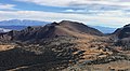
 East aspect | |
| Highest point | |
| Elevation | 12,350 ft (3,764 m) [1] |
| Prominence | 1,200 ft (370 m) [2] |
| Parent peak | Kuna Peak (13,002 ft) [3] |
| Isolation | 2.00 mi (3.22 km) [3] |
| Listing | Vagmarken Club Sierra Crest List [4] |
| Coordinates | 37°50′33″N119°11′23″W / 37.8425738°N 119.1897518°W [1] |
| Dimensions | |
| Length | 3 mi (4.8 km)North-South |
| Width | 2 mi (3.2 km)East-West |
| Naming | |
| Etymology | Washington Bartlett "Dusty" Lewis |
| Geography | |
 Mount Lewis Location in California  Mount Lewis Mount Lewis (the United States) | |
| Location | Ansel Adams Wilderness Mono County, California, U.S. |
| Parent range | Sierra Nevada |
| Topo map | USGS Koip Peak |
| Geology | |
| Rock age | Cretaceous |
| Mountain type | Fault block |
| Rock type(s) | Metamorphic rock, [5] Granodiorite |
| Climbing | |
| First ascent | Unknown [6] |
| Easiest route | class 2 [3] West slope |
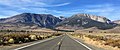
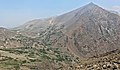
Mount Lewis is a 12,350-foot-elevation (3,760-meter) mountain summit located along the crest of the Sierra Nevada mountain range, in Mono County of northern California, United States. [1] It is situated in the Ansel Adams Wilderness, on land managed by Inyo National Forest. The summit lies less than one mile outside of Yosemite National Park's eastern boundary, and some of the lower western slope lies within the park. The mountain rises 1.8 miles (2.9 km) southeast of Mono Pass, 1.5 miles (2.4 km) northeast of Parker Pass, and two miles north of Parker Peak, which is the nearest higher neighbor. [2] Topographic relief is significant as it rises over 5,200 feet (1,600 meters) above Grant Lake in four miles which makes the mountain visible from Highway 395.