Mount Logan is the highest mountain in Canada and the second-highest peak in North America after Denali. The mountain was named after Sir William Edmond Logan, a Canadian geologist and founder of the Geological Survey of Canada (GSC). Mount Logan is located within Kluane National Park Reserve in southwestern Yukon, less than 40 km (25 mi) north of the Yukon–Alaska border. Mount Logan is the source of the Hubbard and Logan glaciers. Although many shield volcanoes are much larger in size and mass, Mount Logan is believed to have the largest base circumference of any non-volcanic mountain on Earth, including a massif with eleven peaks over 5,000 m (16,000 ft). Mount Logan is the 6th most topographically prominent peak on Earth.

Kluane National Park and Reserve are two protected areas in the southwest corner of the territory of Yukon. The National Park Reserve was set aside in 1972 to become a national park, pending settlement of First Nations land claims. It covered an area of 22,013 square kilometres. When agreement was reached with the Champagne and Aishihik First Nations over an eastern portion of the Reserve, that part—about 5,900 square kilometres —became a national park in 1993, and is a unit of the national park system administered co-operatively with Parks Canada. The larger western section remains a Reserve, awaiting a final land claim settlement with the Kluane First Nation. The park borders British Columbia to the south, while the Reserve borders both British Columbia to the south, and the United States (Alaska) to the south and west.

Mount Saint Elias, the second-highest mountain in both Canada and the United States, stands on the Yukon and Alaska border about 26 miles (42 km) southwest of Mount Logan, the highest mountain in Canada. The Canadian side of Mount Saint Elias forms part of Kluane National Park and Reserve, while the U.S. side of the mountain is located within Wrangell-St. Elias National Park and Preserve.
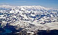
The Saint Elias Mountains are a subgroup of the Pacific Coast Ranges, located in southeastern Alaska in the United States, Southwestern Yukon and the very far northwestern part of British Columbia in Canada. The range spans Wrangell-St. Elias National Park and Preserve in the United States and Kluane National Park and Reserve in Canada and includes all of Glacier Bay National Park in Alaska. In Alaska, the range includes parts of the city/borough of Yakutat and the Hoonah-Angoon and Valdez-Cordova census areas.

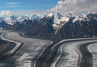
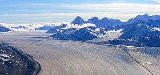
An ice field is a mass of interconnected valley glaciers on a mountain mass with protruding rock ridges or summits. They are often found in the colder climates and higher altitudes of the world where there is sufficient precipitation for them to form. The higher peaks of the underlying mountain rock that protrude through the icefields are known as nunataks. Ice fields are larger than alpine glaciers, but smaller than ice caps and ice sheets. The topography of ice fields is determined by the shape of the surrounding landforms, while ice caps have their own forms overriding underlying shapes.

Mount Augusta, also designated Boundary Peak 183, is a high peak in the US state of Alaska and the Canadian territory of Yukon. It lies about 25 km (16 mi) south of Mount Logan and 25 km east of Mount Saint Elias, respectively the first and second highest mountains in Canada. Mount Augusta forms the eastern end of the long ridge of which Mount Saint Elias is the center and highest point.
Kaskawulsh Mountain is a 2,969-metre (9,741 ft) mountain summit of the Saint Elias Mountains in Kluane National Park of Yukon, Canada. Surrounded by ice on all sides, the mountain is situated in the notch where the main arm of the Kaskawulsh Glacier merges with its south arm. The Stairway Glacier lies to the west, and the Atrypa Glacier to the south. The mountain cannot be seen from any roads, but can be seen by plane, or by hiking to the summit of Observation Mountain which is located at the head of the Slims River valley. The nearest higher peak is GJ43, 3.8 km (2.4 mi) to the west.

Mount Maxwell is a 3,020-metre (9,910-foot) mountain summit of the Saint Elias Mountains in Kluane National Park of Yukon, Canada. The mountain is situated at the toe of the Kaskawulsh Glacier. The mountain cannot be seen from any roads, but can be seen from the Slims River valley. The nearest higher peak is Mount Leacock, 9.2 km (5.7 mi) to the south. The "Mt Maxwell" designation is misplaced five kilometres to the northeast of the actual summit on the topographic map. The mountain was named by John Oliver Wheeler, a Canadian geologist with the Geological Survey of Canada who climbed Maxwell in 1954. The Maxwell name was approved in 1960, and was made official in 1981 by the Geographical Names Board of Canada. However, it remains a mystery who Maxwell was. Based on the Köppen climate classification, Mount Maxwell is located in a subarctic climate with long, cold, snowy winters, and mild summers.

Mount Foresta is an 11,000+ ft multi-peak massif located in Wrangell–St. Elias National Park, in the Saint Elias Mountains of Alaska in the United States. Rising high above the lower western margin of the Hubbard Glacier, the summit of Mount Foresta is just over nine miles (14 km) from tidewater at Disenchantment Bay, 12 mi (19 km) northwest of Mount Seattle, 14.5 mi (23 km) southeast of Mount Vancouver, and 46 mi (74 km) north of Yakutat.

Kings Throne Peak is a 1,990-metre (6,530-foot) mountain summit in the Dalton Range of the Saint Elias Mountains, in Kluane National Park of Yukon, Canada. The mountain is situated above the south shore of Kathleen Lake, 7.2 km (4 mi) southeast of Mount Worthington across the lake, and 27 km (17 mi) south-southeast of Haines Junction, Yukon. The mountain can be seen from the Haines Highway as it prominently rises 1,250-metre (4,100-foot) above the lake. The mountain's descriptive name comes from how it is shaped by a cirque on the north aspect. A rock glacier descends from the cirque to the lake. A steep five kilometre trail provides access to the amphitheatre, and an additional three kilometres on a beaten path reaches the summit via the east ridge. Based on the Köppen climate classification, Kings Throne Peak is located in a subarctic climate zone with long, cold, snowy winters, and mild summers.

Mount Cairnes is a 2,810-metre (9,220-foot) mountain summit in the Saint Elias Mountains on the boundary line of Kluane National Park in Yukon, Canada. The mountain is situated 44 km (27 mi) west of Haines Junction, 18 km (11 mi) southeast of Kluane Lake, and can be seen from the Alaska Highway midway between the two. Its nearest higher peak is Mount Maxwell, 27.7 km (17.2 mi) to the southwest. The mountain's name was officially adopted February 3, 1981, by the Geographical Names Board of Canada. Clive Elmore Cairnes (1892–1954) was active with the Geological Survey of Canada as well as the Geographic Board of Canada until his retirement in 1953. He was related to noted geologist DeLorme Donaldson Cairnes (1879–1917), for whom this mountain is named.
Mount Decoeli is a 2,332-metre (7,651-foot) pyramidal peak located in the Kluane Ranges of the Saint Elias Mountains in Yukon, Canada. The mountain is situated 23 km (14 mi) northwest of Haines Junction, 21.4 km (13 mi) east of Mount Cairnes, and can be seen from the Alaska Highway midway between the two. Its nearest higher peak is Mount Archibald, 6 km (3.7 mi) to the south. The mountain's name was officially adopted August 12, 1980, by the Geographical Names Board of Canada. James J. McArthur was a Canadian surveyor and mountaineer who undertook extensive surveying in the Yukon during his later years. In 1908 he made the first ascent of Williams Peak accompanied by Edmond Treau de Coeli (1873–1963). Decoeli is pronounced deh-coh-lie. To the Southern Tutchone people, the mountain is known as Nàday Gän, meaning Dried Lynx Mountain.

Mount Archibald is a prominent 2,588-metre (8,491-foot) mountain summit located in the Kluane Ranges of the Saint Elias Mountains in Yukon, Canada. The mountain is situated 21 km (13 mi) west of Haines Junction, 5.9 km (4 mi) south of Mount Decoeli, and 27 km (17 mi) east-southeast of Mount Cairnes, which is the nearest higher peak. Set on the boundary line of Kluane National Park, Archibald can be seen from the Alaska Highway, weather permitting. The mountain was named after Edgar Archibald (1885-1968), a Canadian agricultural scientist. The mountain's name was officially adopted August 12, 1980, by the Geographical Names Board of Canada. On a clear day, the summit offers views deep into Kluane National Park of giants such as Mt. Logan, Mt. Vancouver, and Mt. Kennedy.

Mount Martha Black, elevation 2,512-metre (8,241-foot), is the highest point in the Auriol Range of the Saint Elias Mountains in Yukon, Canada. The multi-summit massif is situated 11 km (7 mi) southwest of Haines Junction, 16 km (10 mi) northwest of Mount Worthington, and 18.6 km (12 mi) southeast of Mount Archibald, which is the nearest higher peak. Set within Kluane National Park, Mount Martha Black can be seen from the Alaska Highway, weather permitting. The mountain was named after Martha Black (1866-1957), the second woman elected to the House of Commons of Canada. The mountain's name was officially adopted August 12, 1980, by the Geographical Names Board of Canada.
Mount Turner, also known as Boundary Peak 162, is an 8,661+ foot glaciated mountain summit located in the Fairweather Range of the Saint Elias Mountains, on the Canada–United States border between southeast Alaska and British Columbia. The peak is situated on the shared boundary of Glacier Bay National Park with Tatshenshini-Alsek Provincial Park, 8 mi (13 km) west of Tarr Inlet, and 4.4 mi (7 km) southwest of Mount Forde, which is the nearest peak. Turner is the highest point on the divide which separates Ferris Glacier from Margerie Glacier. The mountain's name was officially adopted by the Geographical Names Board of Canada on March 31, 1924. The mountain was named for George Turner (1850–1932), one of the US members of the 1903 Alaska Boundary Tribunal.

Mount Huxley is a 12,216-foot glaciated mountain summit located in the Saint Elias Mountains of Wrangell-St. Elias National Park and Preserve, in the U.S. state of Alaska. The remote peak is situated 75 mi (121 km) northwest of Yakutat, and 8.7 mi (14 km) west-northwest of Mount Saint Elias. The peak rises above the Columbus Glacier and Bagley Icefield to its north, the Tyndall Glacier to the south, and the Yahtse Glacier to the west. Precipitation runoff from the mountain drains into the Gulf of Alaska. The mountain was named in 1886 by English mountaineer Harold Ward Topham for Thomas Henry Huxley (1825-1895), an English biologist. The mountain was officially named Huxley Peak in 1917, but the name was officially changed to Mount Huxley in 1968 by the U.S. Board on Geographic Names. The first ascent of the peak was made June 9, 1996 by Paul Claus who landed his plane at 11,500 feet elevation on the western flank and climbed the remaining distance to the summit. The second ascent of Mt. Huxley, and first complete ascent from base to summit, was made in June 2018 by Scott Peters, Andrew Peter, and Ben Iwrey starting from the Columbus Glacier.

Sheep Mountain is a 1,953-metre (6,407-foot) mountain summit of the Saint Elias Mountains, in Kluane National Park of Yukon, Canada. It is known as Thechàl Dhâl by the Southern Tutchone people, meaning "Skin Scraper Mountain", referring to the thechàl, a flat stone scraper that was used to prepare animal hides. Sheep Mountain is habitat for Dall sheep, and was once a favorite sheep hunting area for the Southern Tutchone before the park was established. The mountain is a prominent landmark along the Alaska Highway, and topographic relief is significant as the summit rises 1,140 meters above the Thechàl Dhâl Visitor Centre at Kluane Lake in 2.5 kilometers. The mountain can be climbed via an 11 km (6.8 mi) loop which gains 1,310 meters of elevation, part of which is on the Sheep Creek Trail, one of the most popular hikes in Kluane Park. The route provides good opportunities to see Dall sheep, which the mountain is named for. The summit offers views up the Slims River valley to Mount Maxwell, south to Vulcan Mountain, and 2.4 km (1.5 mi) northwest to Mount Wallace, which is the nearest higher neighbor.

Pinnacle Peak is a remote 3,714-meter-elevation (12,184-foot) mountain summit of the Saint Elias Mountains, in Kluane National Park of Yukon, Canada. It ranks as the 37th-highest officially named mountain in Canada. It is situated at the head of the South Arm of the Kaskawulsh Glacier. Topographic relief is significant as the summit rises 1,500 meters (4,920 feet) above the Dusty Glacier in 3.5 kilometers. Neighbors include Mount Kennedy, 14 km to the south, and Mount Alverstone, 14 km to the south-southwest.
Ulu Mountain is a mountain in Yukon, Canada.

Mount Newton is a 4,200-metre (13,780-foot) mountain summit in Yukon, Canada.