Mount Pleasant | |
Location | 15 Bracebridge Rd., Newton, Massachusetts |
---|---|
Coordinates | 42°19′53″N71°12′8″W / 42.33139°N 71.20222°W |
Built | 1856 |
Architectural style | Italianate |
MPS | Newton MRA |
NRHP reference No. | 86001851 [1] |
Added to NRHP | September 04, 1986 |
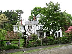
Mount Pleasant is a historic two-story wood frame estate house in Newton Centre, Massachusetts, built circa 1856. It is a well-preserved example of the academic Italianate style of architecture, with a three-bay facade and hip roof with a small gable over the centered entry, and a three-story turret. [2] The house was listed on the National Register of Historic Places in 1986. [1]
The Mount Pleasant house was built for Roswell Turner, a major land owner and real estate developer in the Newton Centre area. The house and surrounding property were owned for many of the later years of the 19th century and early years of the 20th century by Charles S. Davis, another major force in the development of Newton Centre. [2] Under Davis's ownership, much of the original estate was split off for other houses and streets to be built, [3] [4] while the original Mount Pleasant house remained. By 1917, Mr. Addison C. Burnham owned the house and was calling his smaller property "Jolly's Hollow". [5] [6] [7] [8] [9] Subsequent owners continued to call it "Jolly's Hollow", at least into 2018. [10]
In January 1997, the Wilson family, owners of Jolly's Hollow/Mount Pleasant, donated 0.5 acres of the wooded portion of their property to the City of Newton for the creation of the Wilson Conservation Area. In 2012, the Wilsons donated to the Newton Conservators a conservation restriction to preserve an additional 1.5 acres of their land. [11] [12] [13] This conservation land, as intended, adds a link to a popular walking trail that connects a playground, elementary school, and park nearby, and also to suburbs to the west. The walking trail is on top of the underground Cochituate and Sudbury Aqueducts (built in 1848 and 1878, respectively, to supply water to Boston and nearby municipalities). [10] The Mount Pleasant house happens to be situated right between the two aqueducts, which both have easements under the Jolly's Hollow property. [5]
The Wilsons sold the house and property in July 2018 to the Fiete family, having originally purchased it from the Scribner family in March 1966. [14] [15]
Newton is a city in Middlesex County, Massachusetts, United States. It is approximately 7 miles (11 km) west of downtown Boston, and comprises a patchwork of thirteen villages without a city center. It is home to the Charles River, Crystal Lake, and Heartbreak Hill, among other landmarks. It is served by several streets and highways, as well as the Green Line D branch run by the MBTA.
Auburndale is one of the thirteen villages within the city of Newton in Middlesex County, Massachusetts, United States. It lies at the western end of Newton near the intersection of interstate highways 90 and 95. It is bisected by the Massachusetts Turnpike. Auburndale is surrounded by three other Newton villages as well as the city of Waltham and the Charles River. Auburndale is the home of Williams and Burr elementary schools, as well as Lasell College. Auburndale Square is the location of the Plummer Memorial Library, which is run by the Auburndale Community Library and no longer affiliated with the Newton Free Library, the Turtle Lane Playhouse, and many small businesses.
Chestnut Hill is a wealthy New England village located six miles (10 km) west of downtown Boston, Massachusetts, United States. It is best known for being home to Boston College and a section of the Boston Marathon route. Like all Massachusetts villages, Chestnut Hill is not an incorporated municipal entity. It is located partially in Brookline in Norfolk County; partially in the city of Boston in Suffolk County, and partially in the city of Newton in Middlesex County. Chestnut Hill's borders are defined by the 02467 ZIP Code. The name refers to several small hills that overlook the 135-acre Chestnut Hill Reservoir rather than one particular hill.
Rockefeller State Park Preserve is a state park in Mount Pleasant, New York in the eastern foothills of the Hudson River in Westchester County. Common activities in the park include horse-riding, walking, jogging, running, bird-watching, and fishing. The park has a rich history and was donated to the State of New York over time by the Rockefeller family beginning in 1983. A section of the park, the Rockwood Hall property, fronts the Hudson River. It was formerly the private residence of William Rockefeller, and began use as a New York state park in the early 1970s. In 2018, the park was added to New York's State Register of Historic Places.
Newton Centre is one of the thirteen villages within the city of Newton in Middlesex County, Massachusetts, United States. The main commercial center of Newton Centre is a triangular area surrounding the intersections of Beacon Street, Centre Street, and Langley Road. It is the largest downtown area among all the villages of Newton, and serves as a large upscale shopping destination for the western suburbs of Boston. The Newton City Hall and War Memorial is located at 1000 Commonwealth Avenue, and the Newton Free Library is located at 330 Homer Street in Newton Centre. The Newton Centre station of the MBTA Green Line "D" branch is located on Union Street.
Echo Bridge is a historic masonry bridge spanning the Charles River between Needham to Newton Upper Falls, Massachusetts, and Ellis Street in Newton. The bridge carries the Sudbury Aqueduct and foot traffic, and is located in the Hemlock Gorge Reservation. At the time of its construction in 1875–1877, it was the second longest masonry arch in the country.
The Charles River Reservation is a 17-mile-long (27 km) urban preserve and public recreation area located along the banks of the Charles River in Boston, Cambridge, Watertown, and Newton, Massachusetts. The reservation is managed by the Massachusetts Department of Conservation and Recreation.
The Cochituate Aqueduct was an aqueduct in Massachusetts that brought water to Boston from 1848 to 1951.
Chestnut Hill Reservoir is a reservoir located in the Chestnut Hill section of Boston, Massachusetts. It was created in 1870 on existing marshes and meadowland to supplement the city’s water needs. A 1.56 mile jogging loop abuts the reservoir. Chestnut Hill Reservoir was taken offline in 1978 as it was no longer needed for regular water supply distribution, but is maintained in emergency backup status. It is recognized today on the National Register of Historic Places and was designated as a Boston Landmark by the Boston Landmarks Commission in 1989.
Crystal Lake is a 33-acre (130,000 m2) natural great pond located in Newton, Massachusetts. Its shores, mostly lined with private homes, also host two small parks and a designated swimming area with a bathhouse. The public is not allowed to swim outside of the small swimming area.
The Sudbury Aqueduct is an aqueduct in Massachusetts. It runs for 16 miles (26 km) from Farm Pond at Waverly Street in Framingham to Chestnut Hill Reservoir in Boston’s Chestnut Hill neighborhood. A later built extension main runs from the Farm Pond gatehouse to the gatehouse at the Stearns Reservoir where additional mains connect to the Brackett and Foss Reservoirs Going east from Framingham, it runs through Sherborn before entering Natick. From Natick it runs east through Wellesley and Needham to the Charles River, which it crosses on the Echo Bridge into Newton. It ends at the Chestnut Hill Reservoir on the Newton side of the Newton-Boston line. The Massachusetts Water Resources Authority (MWRA) operates the aqueduct.
The Crystal Lake and Pleasant Street Historic District encompasses a streetcar suburban residential subdivision developed between 1860 and 1895 in Newton, Massachusetts. The district roughly bounded by the Sudbury Aqueduct, Pleasant Street, Lake Avenue, Webster Court, and Crystal Street. The subdivision was laid out in the 1850s after the Boston and Charles Railroad line was extended through Newton from Brookline. The district was listed on the National Register of Historic Places in 1986.
Hammond Pond Parkway is a historic parkway in Chestnut Hill, Massachusetts. The road, built in 1932, extends 2 miles (3.2 km) from Hobart Road in Newton to Horace James Circle in Brookline, where it joins the West Roxbury Parkway. It was designed by Charles Eliot and the Olmsted Brothers to provide a parkway setting that provided access from Brookline, Newton, and the western portions of Boston to the southern parks of the Emerald Necklace. The parkway was listed on the National Register of Historic Places in 2004.
Chestnut Hill Reservation is a public recreation area and historic preserve surrounding the Chestnut Hill Reservoir in the Chestnut Hill and Brighton neighborhoods of Boston, Massachusetts, United States. The reserve is part of the Chestnut Hill Reservoir Historic District, is listed on the National Register of Historic Places, and is a City of Boston Landmark. It is managed by the Department of Conservation and Recreation.
Hemlock Gorge Reservation is a state-owned, public recreation area and urban wild comprising 23 acres (9.3 ha) on the Charles River in Newton and Needham, Massachusetts. The reservation is managed by the Massachusetts Department of Conservation and Recreation.
Hammond Pond Reservation is a protected woodland park in Newton, Massachusetts. It features Hammond Pond, fishing and hiking trails as well as formations of sandstone conglomerate and Roxbury puddingstone which are popular for rock climbing.
The Upper Charles River Reservation is a Massachusetts state park encompassing portions of the banks of the Charles River between the Watertown Dam in Watertown and Riverdale Park in Dedham and the West Roxbury neighborhood of Boston. The park is managed by the Massachusetts Department of Conservation and Recreation. It includes land in the communities of Watertown, Waltham, Newton, Weston, Wellesley, Needham, Dedham, and Boston. Some of the Charles River Reservation Parkways also fall within the park boundaries. The Charles River Bike Path follows the river through much of the reservation.
Robert Gould Shaw II was a wealthy landowner, international polo player of the Myopia Hunt Club and socialite in the greater Boston area of Massachusetts. He was one of the prominent figures of the boom years at the turn of the century, sometimes called the Gilded Age.
This is a list of the National Register of Historic Places listings in northern Westchester County, New York, excluding the city of Peekskill, which has its own list.