
Mount Goode is a 13,085-foot-elevation mountain summit located on the crest of the Sierra Nevada mountain range in California, United States. It is situated on the shared boundary of Kings Canyon National Park with John Muir Wilderness, and along the common border of Fresno County with Inyo County. It is also approximately one mile west-northwest of Bishop Pass, one mile east-southeast of Mount Johnson, 1.23 miles (1.98 km) south of Hurd Peak, and 16 miles (26 km) west of the community of Big Pine.

Mount Fiske is a 13,503-foot-elevation mountain summit located near the crest of the Sierra Nevada mountain range, in Fresno County of northern California, United States. It is situated in northern Kings Canyon National Park, 23 miles (37 km) west of the community of Big Pine, 0.83 miles (1.34 km) east of Mount Huxley, and two miles south of Mount Darwin, which is the nearest higher neighbor. Mount Fiske ranks as the 60th highest summit in California.

Mount Warlow is a 13,206-foot-elevation mountain summit located 1.5 miles (2.4 km) west of the crest of the Sierra Nevada mountain range, in Fresno County of northern California, United States. It is situated on the Goddard Divide in northern Kings Canyon National Park, 1.2 miles (1.9 km) north of Muir Pass, 0.69 miles (1.11 km) southeast of Mount Huxley, and 0.68 miles (1.09 km) southwest of Mount Fiske, which is the nearest higher neighbor. Mount Warlow ranks as the 108th highest summit in California. The approach to this remote peak is made via the John Muir Trail.

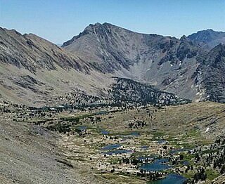
Marion Peak is a remote 12,719-foot-elevation (3,877-meter) mountain summit located in Kings Canyon National Park, in Fresno County of northern California, United States. It is situated on Cirque Crest which is west of the crest of the Sierra Nevada mountain range, 2.13 miles (3.43 km) northeast of State Peak, and 2.6 miles (4.2 km) northwest of Arrow Peak, the nearest higher neighbor. Topographic relief is significant as the north aspect rises 2,400 feet above Marion Lake in one mile, and the southeast aspect rises 3,500 feet above South Fork Kings River in less than two miles.
Colosseum Mountain is a 12,473-foot-elevation double summit mountain located on the crest of the Sierra Nevada mountain range in northern California. It is situated on the common border of Fresno County with Inyo County, as well as the shared boundary of John Muir Wilderness and Kings Canyon National Park. It is 12 miles (19 km) northwest of the community of Independence, 1.2 miles (1.9 km) east of Mount Cedric Wright, 2.6 miles (4.2 km) west of Sawmill Point, and 1.6 miles (2.6 km) south-southeast of Mount Perkins, the nearest higher neighbor. The lower east summit is 12,451-feet in elevation and marked as Colosseum Mountain on maps, but the 12,473-foot west summit is higher. Approximately 1,000 feet distance separate the two summits. The John Muir Trail passes to the west of this peak, providing an approach to the mountain. The first ascent of the summit was made August 5, 1922, by Chester Versteeg, a prominent Sierra Club member, via the southwest face.
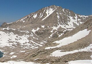
Mount Hilgard is a 13,361-foot-elevation (4,072 meter) mountain summit located west of the crest of the Sierra Nevada mountain range in Fresno County of northern California, United States. It is situated in the John Muir Wilderness on land managed by Sierra National Forest, approximately eight miles east-southeast of Lake Thomas A Edison, and immediately above the west end of Lake Italy. The nearest higher neighbor is Mount Gabb, 1.75 miles (2.82 km) to the northeast, and Recess Peak is 2.2 miles (3.5 km) to the northwest. The John Muir Trail follows Bear Creek to the west of this remote peak, providing an approach. Mt. Hilgard ranks as the 82nd highest summit in California.

Mount McGee is a 12,944-foot-elevation (3,945-meter) mountain summit located west of the crest of the Sierra Nevada mountain range, in Fresno County of central California, United States. It is situated in northern Kings Canyon National Park, 0.6 miles (0.97 km) southeast of Peter Peak, 2 miles (3.2 km) southwest of The Hermit, and 2.6 miles (4.2 km) north-northwest of Mount Goddard, the nearest higher neighbor. Topographic relief is significant as the west aspect rises 3,100 feet above Goddard Canyon in two miles. This geographical feature was named for William John McGee (1853–1912), well-known American geologist and anthropologist. This mountain's name has been officially adopted by the United States Board on Geographic Names. The first ascent of the summit was made in July 1923 by Roger N. Burnham, Robert E. Brownlee, Ralph H. Brandt, and Leonard Keeler.

Kearsarge Peak is a 12,620-foot (3,847 m) mountain located less than two miles east of the crest of the Sierra Nevada mountain range, in Inyo County in northern California. It is situated immediately northwest of Onion Valley in the John Muir Wilderness, on land managed by Inyo National Forest. It is also 8.5 miles (13.7 km) west of the community of Independence, and 2.1 miles (3.4 km) north-northwest of Independence Peak. Topographic relief is significant as the east aspect rises 5,250 feet above Onion Valley in two miles.

Red Peak is an 11,699-foot-elevation (3,566 meter) mountain summit located in the Sierra Nevada mountain range, in Madera County of northern California, United States. It is situated in Yosemite National Park, approximately 10.5 miles (16.9 km) southeast of Yosemite Valley, 1.5 mile (2.4 km) south-southeast of Gray Peak, and 1.5 mile (2.4 km) northwest of Merced Peak, the nearest higher neighbor. Red Peak is the second-highest peak in the Clark Range, which is a subset of the Sierra Nevada. This geographical feature's brilliant color is caused by iron-bearing minerals weathered to an iron rust which colors the granite.

Parker Peak is a 12,861-foot-elevation (3,920-meter) mountain summit located in the Sierra Nevada mountain range, in Mono County of northern California, United States. It is situated in the Ansel Adams Wilderness, on land managed by Inyo National Forest. It is approximately 7.0 miles (11.3 km) northwest of the community of June Lake, 1.2 miles (1.9 km) east of Yosemite National Park's eastern boundary, and 1.0 mile (1.6 km) east of Koip Peak, the nearest higher neighbor. The mountain is visible from the June Lake Loop, and from the nearby June Mountain ski area. Topographic relief is significant as it rises over 5,700 feet above Grant Lake in four miles. The peak's name is derived from Parker Creek, which in turn was named after an early settler of Mono County. This geographical feature's name has been officially adopted by the U.S. Board on Geographic Names. The first ascent of the summit was made in 1914 by Norman Clyde.

Gemini is a 12,880-foot-elevation (3,926-meter) twin-peaked mountain summit located west of the crest of the Sierra Nevada mountain range in Fresno County of northern California, United States. It is situated in the John Muir Wilderness, on land managed by Sierra National Forest. It is set 3.0 miles (4.8 km) west-southwest of Merriam Peak, 2.6 miles (4.2 km) northeast of Mount Senger, and 1.2 miles (1.9 km) southeast of Seven Gables, the nearest higher neighbor. Topographic relief is significant as it rises over 3,500 feet above Piute Canyon in approximately three miles. Gemini ranks as the 176th-highest summit in California.

Mount Tinemaha is a 12,520-foot-elevation (3,820-meter) mountain summit located east of the crest of the Sierra Nevada mountain range, in Inyo County of northern California. It is situated on the eastern boundary of the John Muir Wilderness, on land managed by Inyo National Forest. It is 1.3 mile southeast of Tinemaha Lake, and 1.8 mile northeast of parent Split Mountain. Topographic relief is significant as the east aspect rises 5,900 feet above Owens Valley in two miles.

Mount Young is a 13,176-foot-elevation (4,016-meter) mountain summit located west of the crest of the Sierra Nevada mountain range in Tulare County, California. It is situated in Sequoia National Park, and is two miles (3.2 km) west of Mount Whitney, one mile northwest of Guitar Lake, and one mile southwest of Mount Hale, the nearest higher neighbor. The John Muir Trail traverses below the south and west aspects of the mountain, providing access. Topographic relief is significant as the southwest aspect rises 2,300 feet above Whitney Creek in approximately one mile. Mt. Young ranks as the 117th highest summit in California.

Cirque Peak is a 12,900-foot-elevation (3,900-meter) mountain summit located on the crest of the Sierra Nevada mountain range in California. It is situated on the common border of Tulare County with Inyo County, as well as the shared boundary of Golden Trout Wilderness and John Muir Wilderness, on land managed by Inyo National Forest. It is 14 miles (23 km) southwest of the community of Lone Pine, 7.7 miles (12.4 km) south-southeast of Mount Whitney, and 3.2 miles (5.1 km) south of Mount Langley, the nearest higher neighbor. Cirque Peak is the highest point of the Golden Trout Wilderness, and ranks as the 175th highest peak in California. Topographic relief is significant as it rises 1,800 feet above Cirque Lake in approximately one mile. The Pacific Crest Trail traverses the southwest slope of this mountain, providing an approach option. The mountain was apparently named in 1890 by Joseph Nisbet LeConte and companions who noted the remarkable cirque on the north aspect.

Mount Carillon is a 13,559-foot-elevation (4,133-meter) mountain summit located on the crest of the Sierra Nevada mountain range in California. It is situated on the common border of Tulare County with Inyo County, as well as the shared boundary of Sequoia National Park and John Muir Wilderness. It is set above the south shore of Tulainyo Lake, 12.5 miles (20.1 km) west of the community of Lone Pine, 1.25 miles (2.01 km) northeast of Mount Whitney, and 0.7 miles (1.1 km) east-northeast of Mount Russell, the nearest higher neighbor. Topographic relief is significant as it rises approximately 5,180 feet above Whitney Portal in approximately two miles. Carillon has subpeaks, unofficially called "The Cleaver" (13,383 ft, 0.4 mile to the northeast, and "Impala", on the southeast ridge.
Trojan Peak is a 13,947-foot-elevation (4,251-meter) mountain summit located along the crest of the Sierra Nevada mountain range in Inyo County, California. It is situated in the John Muir Wilderness, on land managed by Inyo National Forest. It is 15 miles (24 km) west-northwest of the community of Lone Pine, 0.7 miles (1.1 km) southeast of Mount Versteeg, and one mile (1.6 km) south-southwest of Mount Williamson, the nearest higher neighbor. Trojan Peak is ranked as the 16th highest peak in California. Topographic relief is significant as it rises 1,427 feet above Lake Helen of Troy in approximately one-half mile.

Mount Genevra is a remote 13,054-foot-elevation (3,979-meter) mountain summit located on the Kings–Kern Divide of the Sierra Nevada mountain range, in Tulare County of northern California. It is situated on the shared boundary of Kings Canyon National Park with Sequoia National Park, 3.5 miles (5.6 km) southeast of Mount Brewer, and 0.86 miles (1.38 km) east of Mount Jordan, which is the nearest higher neighbor. Topographic relief is significant as the north aspect rises 3,025 feet above Lake Reflection in 1.5 mile. Mount Genevra ranks as the 138th highest summit in California, and the eighth highest peak on the Kings–Kern Divide.

Mount Starr, elevation 12,835 feet (3,912 m), is a mountain summit located on the crest of the Sierra Nevada mountain range in northern California, United States. It is situated in the John Muir Wilderness on the common boundary shared by Sierra National Forest with Inyo National Forest, and along the common border of Fresno County with Inyo County. It is bound on the east by Little Lakes Valley, and is 0.8 mile northeast of Mono Pass. Topographic relief is significant as the summit rises 2,300 feet above Little Lakes Valley in approximately one-half mile (0.80 km). Neighbors include Mount Abbot, three miles to the south-southwest, Mount Morgan, 2.5 miles to the southeast, and Pointless Peak is 2.5 miles to the north.

Mount Izaak Walton is a 12,077-foot-elevation (3,681 meter) mountain summit located in the Sierra Nevada mountain range in Fresno County of northern California, United States. It is situated in the John Muir Wilderness, on land managed by Sierra National Forest. Mount Izaak Walton ranks as the 404th-highest summit in California. Topographic relief is significant as the northwest aspect rises 1,800 feet above Izaak Walton Lake in approximately one mile. It is six miles northeast of Lake Thomas A Edison, and approximately 14 miles (23 km) south-southeast of the community of Mammoth Lakes. The peak is set on Silver Divide, so precipitation runoff from the north side of this mountain drains into Fish Creek which is a tributary of the San Joaquin River, and from the south slope to Mono Creek, also a tributary of the San Joaquin.

Mount Bolton Brown is a 13,491-foot-elevation (4,112 meter) mountain summit located on the shared border of Fresno County and Inyo County in California, United States.


