
Alappuzha is one of the 14 districts in the state of Kerala in India. It was formed as Alleppey District on August 17, 1957. The name of the district was officially changed to Alappuzha in 1990. Alleppey town was renamed Alappuzha in 2012, even though the anglicised name is still commonly used to describe the town as well as the district.

Cherpulassery is a town and municipality in the Palakkad district, Kerala, South India. It is home to the Sabarimala temple of Malabar and the Puthanalakkal Bhagavathi Temple.

Turuvekere is a panchayat town and Taluk in Tumkur district in the Indian state of Karnataka.

Mannar is a small business town in Chengannur Taluk near Veeyapuram and Haripad in Alappuzha District of Kerala state, India, on State highway 6. It is also known as the Bell Metal Town.
Kulanada is a village in Pandalam, that is located in the district of Pathanamthitta bordering with Alappuzha district in Kerala state within India. Kulanada assumed its name from the combination of words "Kulam" and "Nada". Kulam meaning pond and Nada meaning the temple where the king of Pandalam worshiped.

Peramangalam is an Indian village in Kerala, 10 kilometres away from Trichur. The district highways connecting Kozhikode and Guruvayoor pass through this village. The famous tourist place Villangankunnu is on the south west side of this village. This village is an example of religious harmony. Peramangalam originates from the name Veeraramamangalam, which itself originated from Peralthrukovu Sreeramaswami Temple in the village. It is a part of Kaiparambu Grama Panchayat, bordering Adat Grama Panchayat.

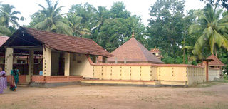
Krishnapuram is a village in Alappuzha district in the Indian state of Kerala.
Pallippad is a village in Alappuzha district in the Indian state of Kerala. The name Pallipad is believed to be derived from the Buddhist terminology. The famous River Achankovil Aar pass by Pallipad before it reaches veeyapuram. the village has abundant water resource, small lakes and water paths which connects to Alapuzha.

Thycattusserry is a village in the Cherthala taluk of the Alappuzha district in the Indian state of Kerala.
Rajakkad is a town in the Idukki district in the Indian state of Kerala situated in the Western Ghats. It is one of Kerala's fastest growing towns.

Thrikkadavoor is a town and a neighbourhood of Kollam city in the state of Kerala, India. It is located approximately 5 kilometres north of Kollam city centre and 30 kilometres away from Paravur, Thrikkadavoor has become a bustling urban center, and is now home to educational institutions, five star hotel, local business establishments and major recent real estate ventures
Thrikkadavoor was a separate panchayath till 2015. In May 2015, Government of Kerala have decided to expand City Corporation of Kollam by merging Thrikkadavoor panchayath.
West Kallada is a village in Kollam district in the state of Kerala, India.

Elangulam is a large village in Kottayam district in the state of Kerala, India under the Palai Assembly constituency. The village comes under the local jurisdiction of Elikkulam Grama Panchayat.
Perumpetty is a village in Pathanamthitta district in the state of Kerala, India.
Karakulam is a village in the Thiruvananthapuram district of the state of Kerala, India.

Ottasekharamangalam is a village in Thiruvananthapuram district in the state of Kerala, India.
Vattappara is a village in Thiruvananthapuram district in the state of Kerala, India. , well known for its geographical peculiarities with quarries that are generally used for extracting building materials (rock).This town is by the side of MC Road connecting Trivandrum and Kottayam and 14 km away from Trivandrum City. The nearest township is Nedumangad.There is no recorded history on the origin of this place. The major occupation in Vattappara is farming(Rubber, Coconut).
Vellatanjur or Vellatanjoor is a small village in the Thrissur, District of Kerala, India on the banks of Kechery river.This village is located 25 km NorthEast of the Thrissur city, 20 km SouthEast of the Kunnamkulam town and 18 km NorthEast of the Guruvayur township where the famous Guruvayur temple is situated.

Ujjini is a village in the southern state of Karnataka, India. It is located in the Kudligi taluk of Bellary district in Karnataka.
Sirwar also spelled as Sirawara is a new taluk of Raichur district in Karnataka state, India. Sirwar is one of the fastest growing town in Karnataka and is famous for Paddy. The business center for almost 30 villages across the region. It is also famous for litchi, which it exports in tonnes.


