
Lynn is the eighth-largest municipality in Massachusetts, United States, and the largest city in Essex County. Situated on the Atlantic Ocean, 3.7 miles (6.0 km) north of the Boston city line at Suffolk Downs, Lynn is part of Greater Boston's urban inner core.

Downtown Omaha is the central business, government and social core of the Omaha–Council Bluffs metropolitan area, U.S. state of Nebraska. The boundaries are Omaha's 20th Street on the west to the Missouri River on the east and the centerline of Leavenworth Street on the south to the centerline of Chicago Street on the north, also including the CHI Health Center Omaha. Downtown sits on the Missouri River, with commanding views from the tallest skyscrapers.

Lynn station is an intermodal transit station in downtown Lynn, Massachusetts. It is a station on the MBTA Commuter Rail Newburyport/Rockport Line and a hub for the MBTA bus system. The rail station and parking garage temporarily closed on October 1, 2022, pending a reconstruction project, while the busway remained open. Interim platforms nearby opened in December 2023.
The Bulfinch Triangle Historic District is a historic district roughly bounded by Canal, Market, Merrimac, and Causeway Streets in the West End of Boston, Massachusetts. The entire district was laid out by architect Charles Bulfinch on land reclaimed from the old Mill Pond, and is now populated by well-preserved commercial buildings from the 1870s through early 1900s. It was added to the National Register of Historic Places in 1986.

The North Attleborough Town Center Historic District encompasses the most historic elements of the central business district of North Attleborough, Massachusetts. The area was developed between about 1860 and 1830 as a center serving the community and the surrounding jewelry manufacturing businesses for which the town was well known. The district, extending along Washington Street between Fisher Street and Bruce Avenue, was added to the National Register of Historic Places in 1985.

The Ayer Main Street Historic District encompasses most of the historic central business district of Ayer, Massachusetts. It extends along Main Street between Park and Columbia Streets, and was mostly developed between 1872 and 1898 as a hub of railroad and roadway-based economic activity. The district was listed on the National Register of Historic Places in 1989.

This is a list of the National Register of Historic Places listings in Detroit, Michigan.
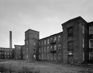
The Renfrew Mill No. 2 was a historic mill complex at 217 Columbia Street in Adams, Massachusetts. Most of its buildings were built between 1867 and 1878, and were brick buildings with Italianate styling. They were built by the Renfrew Manufacturing Company, a textile manufacturer, to replace an earlier complex further down Columbia Street that had been demolished. The property was acquired by the Arnold Print Works in 1928. The mill was the town's largest employer for much of the second half of the 19th century.

The Northampton Downtown Historic District encompasses most of the central business district of Northampton, Massachusetts. This area, which has been a center of commerce and industry in the area since colonial days, extends from the railroad tracks on the east side of the downtown, and west along Main Street to its junction with West Street and Elm Street. When the district was first listed on the National Register of Historic Places, it ended at the railroad tracks, and included properties on a number of other downtown streets; this was extended in 1985 to include a few properties just east of the railroad tracks on and near Bridge Street. The district includes such notable buildings as the 1891 Academy of Music Theatre, and Northampton's castle-like City Hall.

The Downtown Springfield Railroad District is a historic district encompassing a group of early 20th century railroad-related buildings in Springfield, Massachusetts, USA. They are in an area roughly bounded by Lyman, Main, Dwight and Frank B. Murray Streets. The district includes the Union Station, the old freight house, commercial warehouses and a retaining wall and bridge designed in part by H. H. Richardson. The district was added to the National Register of Historic Places in 1983.

The Beverly Center Business District encompasses much of the historic 19th century commercial heart of Beverly, Massachusetts. Centered on Cabot and Church Streets between Central Street and the Beverly Common, its architecture reflects the city's growth over 150 years. The district was added to the National Register of Historic Places in 1984.
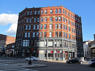
The Central Square Historic District is a historic district encompassing the Central Square area of downtown Lynn, Massachusetts. The area is at the confluence of a number of city streets, and includes buildings that border on Central Avenue, Willow Street, Munroe Street, Lake Street, Almont Street. It is a small part of Lynn's "Burned District", a large area of the downtown that was destroyed by fire in 1889. One of the first buildings built after the fire, the Bergengren Block, stands at the corner of Union Street and Central Square. It also includes the Mowers' Block, listed on the National Register in 1982.
The Diamond Historic District is a seaside, 69.5-acre (28.1 ha) National Register historic district in Lynn, Massachusetts. Established by the National Park Service in 1996, the district is situated between downtown Lynn and the Atlantic Ocean—bounded roughly by Broad and Lewis Streets to the north, Lynn Shore Drive to the southeast, Nahant Street to the west, and Eastern Avenue to the east. The Diamond Historic District encompasses 590 contributing resources.

The Kendal Green Historic District is a rural residential district running along North Avenue in Weston, Massachusetts. It extends for about three-quarters of a mile, and includes elements representative of the development of Weston from a rural agricultural community to a residential suburb of Boston. In addition to a variety of predominantly residential and agricultural properties, it includes two formerly industrial sites important in Weston's history: the site of the Hobbs Tannery, and that of the Hook and Hastings Organ Factory. The district was listed on the National Register of Historic Places in 2000.

Wakefield Centre station is a former railway station at 57 Water Street (Route 129) in Wakefield, Massachusetts. Built in the early 1870s, it is a surviving element of the railroad infrastructure that enabled Wakefield's growth as an industrial center in the late 19th century. The depot was added to the National Register of Historic Places in 1989 as Centre Depot. As of 2008, the former depot serves as a restaurant.

This is a list of the National Register of Historic Places listings in Downtown and Midtown Detroit, Michigan. It is intended to be a complete list of the properties and districts on the National Register of Historic Places in Downtown and Midtown neighborhoods in Detroit, Michigan, United States. Latitude and longitude coordinates are provided for many National Register properties and districts; these locations may be seen together in online maps.

The Kimball Brothers Shoe Factory is a historic factory building at 335 Cypress Street in Manchester, New Hampshire. The four-story brick building was built in stages between 1885 and 1900, and was a prototypical structure from which the design of other period shoe factories in Manchester were built. Construction was overseen by Head & Dowst, a builder responsible for a number of area public buildings, including schools and prisons. It was funded by local businessmen seeking to diversify the local economy, and was leased to the Kimball Brothers, a leading shoe manufacturer in Lynn, Massachusetts. The building was listed on the National Register of Historic Places in 1985.

The Rochester Commercial and Industrial District encompasses the civic, commercial, and industrial heart of Rochester, New Hampshire. Oriented around the city's Central Square, the 6-acre (2.4 ha) district includes the city's major civic buildings, most of which are Classical Revival structures from the early 20th century, a number of commercial buildings dating as far back as the square's formation in the 1820s, and several late 19th-century industrial facilities. The district extends primarily along Main Street, from Bridge and Union Streets to Winter and Academy Streets, and includes properties extending along Wakefield and Hanson Streets, as well as other adjacent streets. The district was listed on the National Register of Historic Places in 1983.

The Canal Street–Clark Street Neighborhood Historic District encompasses a compact 19th-century working-class neighborhood of Brattleboro, Vermont. Most of its buildings are modest vernacular wood-frame buildings, erected between 1830 and 1935; there are a few apartment blocks, and one church. The district was listed on the National Register of Historic Places in 1993.

The Bethel Village Historic District encompasses the historic core of the village of Bethel in the town of Bethel, Vermont, USA. The L-shaped district extends along Main and Church Streets, including many of the village's commercial and civic buildings, as well as a significant number of 19th and early 20th-century residences. The district was listed on the National Register of Historic Places in 1976, and was slightly enlarged in 1990.


