The Ku band is the portion of the electromagnetic spectrum in the microwave range of frequencies from 12 to 18 gigahertz (GHz). The symbol is short for "K-under", because it is the lower part of the original NATO K band, which was split into three bands because of the presence of the atmospheric water vapor resonance peak at 22.24 GHz, (1.35 cm) which made the center unusable for long range transmission. In radar applications, it ranges from 12 to 18 GHz according to the formal definition of radar frequency band nomenclature in IEEE Standard 521–2002.

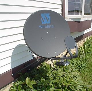
A very-small-aperture terminal (VSAT) is a two-way satellite ground station with a dish antenna that is smaller than 3.8 meters. The majority of VSAT antennas range from 75 cm to 1.2 m. Bit rates, in most cases, range from 4 kbit/s up to 16 Mbit/s. VSATs access satellites in geosynchronous orbit or geostationary orbit to relay data from small remote Earth stations (terminals) to other terminals or master Earth station "hubs".
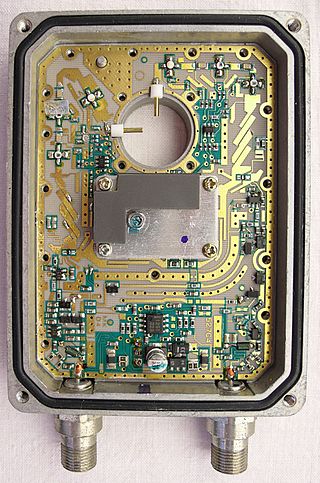
A low-noise block downconverter (LNB) is the receiving device mounted on satellite dishes used for satellite TV reception, which collects the radio waves from the dish and converts them to a signal which is sent through a cable to the receiver inside the building. Also called a low-noise block, low-noise converter (LNC), or even low-noise downconverter (LND), the device is sometimes inaccurately called a low-noise amplifier (LNA).
The Ka band is a portion of the microwave part of the electromagnetic spectrum defined as frequencies in the range 26.5–40 gigahertz (GHz), i.e. wavelengths from slightly over one centimeter down to 7.5 millimeters. The band is called Ka, short for "K-above" because it is the upper part of the original NATO K band, which was split into three bands because of the presence of the atmospheric water vapor resonance peak at 22.24 GHz (1.35 cm), which made the center unusable for long range transmission. The 30/20 GHz band is used in communications satellite uplinks in either the 27.5 GHz or 31 GHz bands, and in high-resolution, close-range targeting radars aboard military airplanes. Some frequencies in this radio band are used for vehicle speed detection by law enforcement. The Kepler Mission used this frequency range to downlink the scientific data collected by the space telescope.
Satellite Internet access is Internet access provided through communication satellites; if it can sustain high speeds, it is termed satellite broadband. Modern consumer grade satellite Internet service is typically provided to individual users through geostationary satellites that can offer relatively high data speeds, with newer satellites using the Ku band to achieve downstream data speeds up to 506 Mbit/s. In addition, new satellite internet constellations are being developed in low-earth orbit to enable low-latency internet access from space.
Thuraya is a United Arab Emirates-based regional mobile-satellite service (MSS) provider. The company operates two geosynchronous satellites and provides telecommunications coverage in more than 161 countries in Europe, the Middle East, North, Central and East Africa, Asia and Australia. Thuraya's L-band network delivers voice and data services.

Satellite television is a service that delivers television programming to viewers by relaying it from a communications satellite orbiting the Earth directly to the viewer's location. The signals are received via an outdoor parabolic antenna commonly referred to as a satellite dish and a low-noise block downconverter.
Astra 5°E is the name for the Astra communications satellites co-located at the 5° east position in the Clarke Belt which are owned and operated by SES based in Betzdorf, Luxembourg. 5° east is one of the major TV satellite positions serving Europe.
Astra 4A is one of the Astra communications satellites owned and operated by SES at the Astra 5°E orbital slot providing digital television and radio broadcasts, data, and interactive services to Nordic countries, eastern Europe and sub-Saharan Africa in the 11.70 GHz-12.75 GHz range of the Ku band and 18.8 GHz-21.75 GHz range of the Ka band.
The Intelsat VI series of satellites were the 8th generation of geostationary communications satellites for the Intelsat Corporation. Designed and built by Hughes Aircraft Company (HAC) in 1983-1991, there were five VI-series satellites built: 601, 602, 603, 604, and 605.
A Satellite contribution link or service is a means to transport video programming by a satellite link from a remote source to a broadcaster's studio or from the studio to a satellite TV uplink centre.
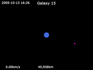
Galaxy 15 is an American telecommunications satellite which is owned by Intelsat. It was launched for and originally operated by PanAmSat, and was subsequently transferred to Intelsat when the two companies merged in 2006. It was originally positioned in geostationary orbit at a longitude of 133° West, from where it was used to provide communication services to North America.

Intelsat 901 (IS-901) is the first of nine new Intelsat satellites launched in June 2001 at 18° West, providing Ku-band spot beam coverage for Europe and C-band coverage for the Atlantic Ocean region. It is capable of selectable split uplink for Satellite news gathering (SNG), tailored for increased communications demands such as DTH and Internet.
Eutelsat 70B is a commercial communications satellite run by Eutelsat. It was launched on 3 December 2012 and is designed to provide telecommunication services for the Middle East, Central Asia, South East Asia and parts of Africa. It will replace Eutelsat 70A, which was previously known as Eutelsat W5. That satellite, which was launched in 2002, currently occupies the same 70.5° E location this satellite is intended for.
X band or SHF Satellite Communication is widely used by military forces for beyond line of sight communications. X band is used because it provides a compromise between the characteristics of different frequency bands which is particularly suited to the needs of military users. The characteristics include interference and rain resilience, terminal size, data rates, remote coverage and whether it is reserved for governmental use.

Es'hail 2 is a Qatari satellite, launched aboard a SpaceX Falcon 9 rocket on November 15, 2018. Es'hail 2 was built by Japan's Mitsubishi Electric company, and operates at 26° East longitude along a geostationary orbit to provide direct-to-home television services in the Middle East and North Africa region. The satellite features 24 Ku-band and 11 Ka-band transponders to provide direct broadcasting services for television, government and commercial content distribution. In addition to commercial services, the payload of Es'hail 2 includes a linear transponder with a bandwidth of 500 kHz and 8 MHz for the amateur radio satellite service, with uplink on 2.4 GHz and downlink on 10.45 GHz.

The C band is a designation by the Institute of Electrical and Electronics Engineers (IEEE) for a portion of the electromagnetic spectrum in the microwave range of frequencies ranging from 4.0 to 8.0 gigahertz (GHz). However, the U.S. Federal Communications Commission C band proceeding and auction, designated 3.7–4.2 GHz as C band. The C band is used for many satellite communications transmissions, some Wi-Fi devices, some cordless telephones, as well as some radar and weather radar systems.
Intelsat 704 is a geostationary communication satellite that was built by Space Systems/Loral (SSL). It is located in the orbital position of 29.5 degrees east longitude and it is currently in an inclined orbit. The same is owned by Intelsat and after sold to SES World Skies on November 30, 1998. The satellite was based on the LS-1300 platform and its estimated useful life was 15 years.
Intelsat 706 is a geostationary communication satellite that was built by Space Systems/Loral (SSL). It is located in the orbital position of 157 degrees east longitude and it is currently in an inclined orbit. The same is owned by Intelsat. The satellite was based on the LS-1300 platform and its estimated useful life was 15 years.
NSS-806, before Intelsat 806, is a communications satellite originally operated by Intelsat. Launched in 1998 it was operated in geostationary orbit at a longitude of 47 degrees west for around 15 years. It is currently located in the orbital position of 47.5 degrees west longitude, was initially operated by Intelsat, orbited at 40.5 degrees west, and was purchased by SES World Skies.