Jdeideh, also Jdayde, Jdaideh and Jdeidet el-Matn, is a coastal municipality and the administrative capital of the Matn District in the Mount Lebanon Governorate.
Majdal Anjar is a village of Beqaa Governorate, Lebanon. Majdal Anjar is an overwhelmingly Sunni Muslim town.
Sin el-Fil is a suburb east of Beirut in the Matn District of the Mount Lebanon Governorate, Lebanon.
Moukhtara is a small town in the Chouf District of the Mount Lebanon Governorate of Lebanon. The town's inhabitants are mostly Druze, with a Christian minority. It is the hometown of Walid Jumblatt, the leader of Lebanon's Progressive Socialist Party.
Kaukaba, Kaukabet El-Arab or Kaukaba Station is a village in the Hasbaya District in the Nabatiye Governorate in southern Lebanon.
The Sands of Beirut were a series of archaeological sites located on the coastline south of Beirut in Lebanon.
Reverend Father Auguste Bergy was a French Jesuit archaeologist known for his work on prehistory in Lebanon.
Tahun ben Aissa is an archaeological site about 3.5 kilometres southwest of Joub Jannine in the Beqaa Valley in Lebanon.
Tell Deir is an archaeological site approximately halfway between Joub Jannine and Chtaura in Lebanon.
Antelias Cave was a large cave located 2.5 km (1.6 mi) east of Antelias, 10 km (6.2 mi) northeast of Beirut close to the wadi of Ksar Akil.
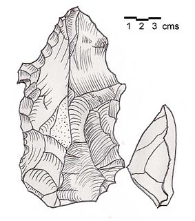
Hadeth Beirut or Hadeth south is a Heavy Neolithic archaeological site approximately 7 kilometres (4.3 mi) south southeast of Beirut, on the road to Sidon in Lebanon. It was discovered and a collection made by Auguste Bergy from a spur near a ravine south of the last houses in the village. Heavy Neolithic material of the Qaraoun culture was found of an atypical variety with large, rough flakes including picks, choppers and cores. Some examples showed evidence of burin impacts and twisted forms. The area is now built up.
Ourrouar is a series of archaeological sites approximately 8.5 kilometres (5.3 mi) south southeast of Beirut, Lebanon. It is near Hadeth south on the north side of the Nahr Ghedir.
Tell Khardane is a Heavy Neolithic archaeological site of the Qaraoun culture north northeast of Aammiq, Lebanon on the road to Chtaura. Several Heavy Neolithic flints including picks, scrapers, blades and flakes were found in fields that surround the tell mound. Many had been produced using the Levallois technique.
Tell Zenoub is a local authority in the Western Beqaa District in Lebanon
Bustan Birke or Boustan el Birke is a Heavy Neolithic archaeological site of the Qaraoun culture that is located 2.5 kilometres (1.6 mi) southeast of Kefraya, Lebanon.
Amlaq Qatih or Amlaq el Qatih is a Heavy Neolithic archaeological site of the Qaraoun culture that is located 2.5 kilometres (1.6 mi) northwest of Baaloul, 5 kilometres (3.1 mi) north of Qaraoun, Lebanon.
Kfar Tebnit or Kfar Tibnit is a village located approximately 4 kilometres (2.5 mi) south southeast of Nabatieh, 37 kilometres (23 mi) southeast of Sidon in Lebanon.
Ard Saouda or Ard es Saoude is a Heavy Neolithic archaeological site of the Qaraoun culture that is located in the Wadi al-Taym, between Rashaya and Marjayoun in Lebanon. It is south of the branch road to Qaraoun and Kaukaba at cote 990, on the surface of fields covered in large blocks of basalt, made from an ancient lava.
Flaoui or Fleywe or Flaoueh is a small village located 17 kilometres (11 mi) northwest of Baalbek, Lebanon in Baalbek District, Baalbek-Hermel Governorate, Lebanon. It is located near the north-south road that runs from Bodai to Chlifa.
Tell Nahariyah is an archaeological site in the Beqaa Mohafazat (Governorate) in Lebanon. It is located c. 2.7 miles (4.3 km) south of Rayak situated on the left bank of the Litani river. It was discovered in 1963 by Diana Kirkbride who examined recovered material with Maurice Dunand. Neolithic, Chalcolithic and Bronze Age materials were found and discussed by James Mellaart and Lorraine Copeland. The area is now under cultivation.