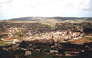
Bint Jbeil is the second largest town in the Nabatiye Governorate in Southern Lebanon.

The Battle of Bint Jbeil was one of the main battles of the 2006 Lebanon War. Bint Jbeil is a major town of some 20,000 inhabitants in Southern Lebanon. Although Brigadier General Gal Hirsch announced on 25 July that the Israel Defense Forces (IDF) had "complete control" of Bint Jbeil, this statement was later discredited. In spite of three sustained attempts by the IDF to conquer the town, it remained in the hands of Hezbollah until the end of the war. The town was the scene of some of the fiercest fighting of the war, with both sides taking heavy losses. Three senior Israeli officers, including Major Roi Klein, were killed in the battle. Hezbollah similarly lost several commanders, most notably Khalid Bazzi, commander of the Bint Jbeil area.

Joub Jannine is located in the Beqaa Valley in Lebanon.
The Nachcharini cave is located at a height of 2,100 m (6,889.76 ft) on the Nachcharini Plateau in the Anti-Lebanon mountains near the Lebanese/Syrian border and among the most elevated Natufian and Khiamian hunter-gatherer occupation sites found to date.
The Sands of Beirut were a series of archaeological sites located on the coastline south of Beirut in Lebanon.

Qaraoun is a Lebanese village, 85 km from Beirut, known for its Lake Qaraoun in the Beqaa Valley formed by the El Wauroun Dam built in 1959. It is an ecologically fragile zone in the Western Beqaa District. The village lies about 800 m above sea level. The dam is located nearby on the Litani River.
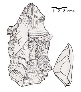
Heavy Neolithic is a style of large stone and flint tools associated primarily with the Qaraoun culture in the Beqaa Valley, Lebanon, dating to the Epipaleolithic or early Pre-Pottery Neolithic at the end of the Stone Age. The type site for the Qaraoun culture is Qaraoun II.
Mtaileb or Mtayleb is a suburb north of Beirut in the Matn District of Mount Lebanon Governorate in Lebanon.
Ourrouar is a series of archaeological sites approximately 8.5 kilometres (5.3 mi) south southeast of Beirut, Lebanon. It is near Hadeth south on the north side of the Nahr Ghedir.
Bustan Birke or Boustan el Birke is a Heavy Neolithic archaeological site of the Qaraoun culture that is located 2.5 kilometres (1.6 mi) southeast of Kefraya, Lebanon.
Amlaq Qatih or Amlaq el Qatih is a Heavy Neolithic archaeological site of the Qaraoun culture that is located 2.5 kilometres (1.6 mi) northwest of Baaloul, 5 kilometres (3.1 mi) north of Qaraoun, Lebanon.
Ard Saouda or Ard es Saoude is a Heavy Neolithic archaeological site of the Qaraoun culture that is located in the Wadi al-Taym, between Rashaya and Marjayoun in Lebanon. It is south of the branch road to Qaraoun and Kaukaba at cote 990, on the surface of fields covered in large blocks of basalt, made from an ancient lava.
Baidar ech Chamout, Baïdar ech Chamoût or Beidar Chamout is a small village located 3 kilometres (1.9 mi) northeast of Machgara in the Western Beqaa District of Beqaa Governorate in Lebanon.
Wadi Koura is a wadi located west of Ain Ebel in the Bint Jbeil District of Nabatieh Governorate in Lebanon.
Wadi Yaroun, Wadi Yarun, Wadi Jarun, Wadi Hanine, Jarun or Jareon is a wadi located south of Ain Ebel in the Bint Jbeil District of Nabatieh Governorate in Lebanon. After it reaches Yaroun it is called the Wadi Nahle or Wadi Nalesh and after reaching Debel it is called the Wadi Ayun et Tannour.
Khalid Ahmad Bazzi was a commander in Hizbullah's military wing, the Islamic Resistance in Lebanon. In the 2006 Lebanon War he was commanding officer in the defence of Maroun ar-Ras and Bint Jbeil. The heavy Israeli casualties and lack of progress of its army in these two battles is widely seen as the main cause of the Israeli failure in the war.
Khallet el Hamra or Khallet Hamra is a ravine or wadi joining the larger Wadi Yaroun located 1 kilometre (0.62 mi) southeast of Ain Ebelin the Bint Jbeil District of Nabatieh Governorate in Lebanon.
Douwara is a Heavy Neolithic archaeological site of the Qaraoun culture located 2 kilometres (1.2 mi) southwest of Ain Ebel in the Bint Jbeil District of Nabatieh Governorate in Lebanon. It is located on slopes north of the road from Ain Ebel to Rmaich.
Qalaat Tannour is a Shepherd Neolithic archaeological site located halfway between Britel and Haour Taala, 12 kilometres (7.5 mi) southwest of Baalbek in the Baalbek District of the Beqaa Governorate in Lebanon.
At Tiri is a village located in the Caza of Bint Jbeil in the Nabatiye Governorate in Lebanon. It is also the location of two pre-historic archaeological sites.
