
Joub Jannine is a city located in the Beqaa Valley in Lebanon.
Jdeideh, also Jdayde, Jdaideh and Jdeidet el-Matn, is a coastal municipality and the administrative capital of the Matn District in the Mount Lebanon Governorate.
Sin el-Fil is a suburb east of Beirut in the Matn District of the Mount Lebanon Governorate, Lebanon.
Neba'a Faour, Tell Neba'a Faour, Mashna'et el Faour, Neba Faour or Nebaa Faour is a large, low-lying archaeological tell mound in the Bekaa Valley, Lebanon inhabited in the late 7th and early 6th millennium BC. It was initially discovered by Lorraine Copeland and Peter J. Wescombe in 1965 near the road from Beirut to Damascus, 5 miles from the border with Syria. The site was mainly composed of soil and pebbles on limestone bedrock, the site showed heavy erosion since it was abandoned and recent damage from modern construction in the area. It has been suggested as an example of an aceramic stage following the Pre-Pottery Neolithic B (PPNB) that is called the Pre-Pottery Neolithic C (PPNC); sites of comparable culture are Tell Ramad, Labwe and others in the Byblos region. It is generally dated between the second half of the 7th millennium and the beginning of the 6th millennium BC.
Hashbai or Tell Hashbai is an archaeological site on the west of the Beqaa Valley in Lebanon.
Tell Ain Nfaikh or Ain Nfaikh is an archaeological site in an area c. 100 square metres (1,100 sq ft) of a ploughed field 300 metres (980 ft) east of the Litani, north of Rayak on the west of the Beqaa Valley in Lebanon.
Mayrouba is a village and municipality in the Keserwan District of the Keserwan-Jbeil Governorate in Lebanon. Its average elevation is 1,300 metres (4,300 ft) above sea level and its total land area is 823 hectares. Mayrouba's inhabitants are almost predominantly Maronite Catholic. As of 2008, the village had a school with 50 pupils and seven businesses with over five employees.
Heavy Neolithic is a style of large stone and flint tools associated primarily with the Qaraoun culture in the Beqaa Valley, Lebanon, dating to the Epipaleolithic or early Pre-Pottery Neolithic at the end of the Stone Age. The type site for the Qaraoun culture is Qaraoun II.

Shepherd Neolithic is a name given by archaeologists to a style of small flint tools from the Hermel plains in the north Beqaa Valley, Lebanon. The Shepherd Neolithic industry has been insufficiently studied and was provisionally named based on a limited typology collected by Jesuit archaeologist "Père" Henri Fleisch. Lorraine Copeland and Peter J. Wescombe suggested it was possibly "of quite late date".
Antelias Cave was a large cave located 2.5 km (1.6 mi) east of Antelias, 10 km (6.2 mi) northeast of Beirut close to the wadi of Ksar Akil.
Mtaileb or Mtayleb is a suburb north of Beirut in the Matn District of Mount Lebanon Governorate in Lebanon.
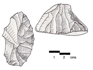
Akbiyeh is an archaeological site approximately 12 kilometres (7.5 mi) south of Sidon, northeast of Ain Kantarah in Lebanon. The area of black soil around 600 metres (2,000 ft) by 30 metres (98 ft) was found by Godefroy Zumoffen in 1894. Material recovered is in the Museum of Lebanese Prehistory including four bifaces of Lower Paleolithic form along with a variety of material suggested to be Middle Paleolithic and Heavy Neolithic of the Qaraoun culture. These include a number of rectangular picks, rough cores and flakes in various conditions. The site is now under cultivation.
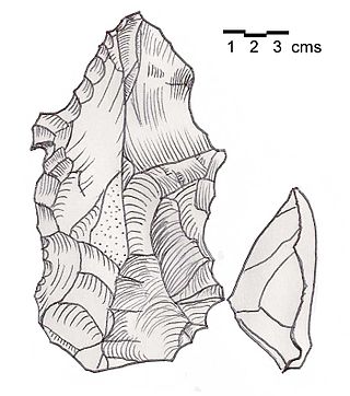
Jebel Aabeby is an archaeological site approximately 2 kilometres (1.2 mi) southeast of Sidon, to the west of the road north to Qraye in Lebanon. The site is on a hill where a number of Cedar trees surround the Mar Elias monastery on the western side of the summit. A Heavy Neolithic assemblage of flint tools made by the Qaraoun culture was collected from some Olive terraces bordering on the road and from an area above them that was disturbed in the construction of a trackway. The flint was of a brown, Nummulitic, Eocene type, some having been patinated to white while others were found fresh. Several broad blades were found along with heavy scrapers on flakes, massive cores, rabots, racloirs and a few smaller scrapers. The material now stored in the Museum of Lebanese Prehistory was studied by Henri Fleisch, who concluded that the site was likely used as a prehistoric factory.
In archaeology, a grattoir de côté is a ridged variety of steep-scraper distinguished by a working edge on one side. They were found at various archaeological sites in Lebanon including Ain Cheikh and Jdeideh II and are suggested to date to Upper Paleolithic stages three or four.
Ourrouar is a series of archaeological sites approximately 8.5 kilometres (5.3 mi) south southeast of Beirut, Lebanon. It is near Hadeth south on the north side of the Nahr Ghedir.
Baidar ech Chamout, Baïdar ech Chamoût or Beidar Chamout is a small village located 3 kilometres (1.9 mi) northeast of Machgara in the Western Beqaa District of Beqaa Governorate in Lebanon.

Wadi Yaroun, Wadi Yarun, Wadi Jarun, Wadi Hanine, Jarun or Jareon is a wadi located south of Ain Ebel in the Bint Jbeil District of Nabatieh Governorate in Lebanon. After it reaches Yaroun it is called the Wadi Nahle or Wadi Nalesh and after reaching Debel it is called the Wadi Ayun et Tannour.

Flaoui or Fleywe or Flaoueh is a small village located 17 kilometres (11 mi) northwest of Baalbek, Lebanon in Baalbek District, Baalbek-Hermel Governorate, Lebanon. It is located near the north–south road that runs from Bodai to Chlifa.

Tell Ain el Meten is a tell in the area of El Meten in the Rashaya District, south-eastern portion of the Bekaa Governorate of the Republic of Lebanon. It is located opposite the village of Sawiri.
Maqne or Maakne is a town and municipality in Baalbek District, Baalbek-Hermel Governorate, Lebanon.

