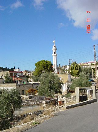
Ain Ebel is a village located in the Lebanese Upper Galilee in the Caza of Bint Jbeil in the Nabatieh Governorate in Lebanon, about 90 kilometers south of the capital Beirut. It is one of the few Christian towns in the area, and is mostly surrounded by Muslim towns like Bint Jbeil.

Hermel is a town in Baalbek-Hermel Governorate, Lebanon. It is the capital of Hermel District. Hermel is home to a Lebanese Red Cross First Aid Center. Hermel's inhabitants are predominantly Shia Muslims.
Southern Lebanon is the area of Lebanon comprising the South Governorate and the Nabatiye Governorate. The two entities were divided from the same province in the early 1990s. The Rashaya and Western Beqaa Districts, the southernmost districts of the Beqaa Governorate, in Southern Lebanon are sometimes included.
Yaroun is a Lebanese village located in the Caza of Bint Jbeil in the Nabatieh Governorate in Lebanon.
Al-Bireh, El Bire, Biré, El Bireh or Birra is a town in the Rashaya District, south-eastern portion of the Bekaa Governorate of the Republic of Lebanon. Al-Bireh is part of the Rashaya municipal district. It lies west of the road between Majdel Anjar and Rashaya. Its population is estimated to be 9000. It is a small Muslim town with two mosques and two schools.

The Yarmukian culture was a Pottery Neolithic A (PNA) culture of the ancient Levant. It was the first culture in prehistoric Syria and one of the oldest in the Levant to make use of pottery. The Yarmukian derives its name from the Yarmuk River, which flows near its type site of Sha'ar HaGolan, near Kibbutz Sha'ar HaGolan at the foot of the Golan Heights. This culture existed alongside the Lodian, or Jericho IX culture and the Nizzanim culture to the south.

Sin el-Fil is a suburb east of Beirut in the Matn District of the Mount Lebanon Governorate, Lebanon.
Hashbai or Tell Hashbai is an archaeological site on the west of the Beqaa Valley in Lebanon.
Tell Ain Nfaikh or Ain Nfaikh is an archaeological site in an area c. 100 square metres (1,100 sq ft) of a ploughed field 300 metres (980 ft) east of the Litani, north of Rayak on the west of the Beqaa Valley in Lebanon.
The Sands of Beirut were a series of archaeological sites located on the coastline south of Beirut in Lebanon.
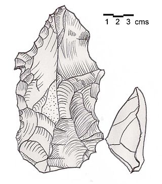
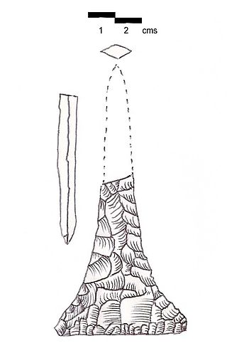
Heavy Neolithic is a style of large stone and flint tools associated primarily with the Qaraoun culture in the Beqaa Valley, Lebanon, dating to the Epipaleolithic or early Pre-Pottery Neolithic at the end of the Stone Age. The type site for the Qaraoun culture is Qaraoun II.
Ourrouar is a series of archaeological sites approximately 8.5 kilometres (5.3 mi) south southeast of Beirut, Lebanon. It is near Hadeth south on the north side of the Nahr Ghedir.
Haret ech Cheikh, is a municipality in the Matn District in the Mount Lebanon Governorate near Bouchriyeh.
Ard Saouda or Ard es Saoude is a Heavy Neolithic archaeological site of the Qaraoun culture that is located in the Wadi al-Taym, between Rashaya and Marjayoun in Lebanon. It is south of the branch road to Qaraoun and Kaukaba at cote 990, on the surface of fields covered in large blocks of basalt, made from an ancient lava.
Khallet Michte is a Heavy Neolithic archaeological site of the Qaraoun culture located in the Caza of Bint Jbeil in the Nabatiye Governorate in Lebanon. The two sites Khallet Michte I and Khallet Michte II are located in adjacent wadis on south facing slopes between a track and the main road between Bint Jbeil and Ain Ebel. They were found by Henri Fleisch and noted to contain both Heavy Neolithic and Acheulean flint tools which are now in the collection of the Museum of Lebanese Prehistory at the Saint Joseph University.

Wadi Koura is a wadi located west of Ain Ebel in the Bint Jbeil District of Nabatieh Governorate in Lebanon.
Khallet el Hamra or Khallet Hamra is a ravine or wadi joining the larger Wadi Yaroun located 1 kilometre (0.62 mi) southeast of Ain Ebelin the Bint Jbeil District of Nabatieh Governorate in Lebanon.
Douwara is a Heavy Neolithic archaeological site of the Qaraoun culture located 2 kilometres (1.2 mi) southwest of Ain Ebel in the Bint Jbeil District of Nabatieh Governorate in Lebanon. It is located on slopes north of the road from Ain Ebel to Rmaich.
Tell Ain el Meten is a tell in the area of El Meten in the Rashaya District, south-eastern portion of the Bekaa Governorate of the Republic of Lebanon. It is located opposite the village of Sawiri.
At Tiri is a village located in the Caza of Bint Jbeil in the Nabatiye Governorate in Lebanon. It is also the location of two pre-historic archaeological sites.