Duris, Dūris, or Dûris, formally Doris and also known by its French spelling Douris, is a village located approximately 3 km (2 mi). southwest of Baalbek in the Bekaa Valley, Lebanon. It is the site of a 13th-century Muslim shrine and a necropolis from the late Roman Imperial period that is currently undergoing archaeological investigation.
Kaukaba, Kaukabet El-Arab or Kaukaba Station is a village in the Hasbaya District in the Nabatiye Governorate in southern Lebanon.
Neba'a Faour, Tell Neba'a Faour, Mashna'et el Faour, Neba Faour or Nebaa Faour is a large, low-lying archaeological tell mound in the Bekaa Valley, Lebanon inhabited in the late 7th and early 6th millennium BC. It was initially discovered by Lorraine Copeland and Peter J. Wescombe in 1965 near the road from Beirut to Damascus, 5 miles from the border with Syria. The site was mainly composed of soil and pebbles on limestone bedrock, the site showed heavy erosion since it was abandoned and recent damage from modern construction in the area. It has been suggested as an example of an aceramic stage following the Pre-Pottery Neolithic B (PPNB) that is called the Pre-Pottery Neolithic C (PPNC); sites of comparable culture are Tell Ramad, Labwe and others in the Byblos region. It is generally dated between the second half of the 7th millennium and the beginning of the 6th millennium BC.
Tell Deir is an archaeological site approximately halfway between Joub Jannine and Chtaura in Lebanon.
Tell Mureibit is a Heavy Neolithic archaeological site approximately 8 kilometres (5 mi) north of Tyre, Lebanon. It is located in a wadi near Qasimiye, Qasimiyeh or Kasimiyeh on the north bank of the Litani river. Material was collected by E. Passemard which is kept in the National Museum of Beirut. It consists of heavy, rough and usually bifacial tools of indeterminate date that has been likened to other Heavy Neolithic material of the Qaraoun culture.
Nabi Zair is a Heavy Neolithic archaeological site of the Qaraoun culture approximately 1.5 kilometres (0.93 mi) northwest of Anjar, Lebanon. The site was discovered by Auguste Bergy who found an abundance of flints spread across a wide area around the road between Beirut and Damascus. Bergy found a skull he described as "protohistoric" on the bank of the river near the Nahr Zghail bridge. The skull was studied by Boule in 1939 and gave some evidence of an ancient site in the area. Islamic tombs were also noted in the area.
Tell Zenoub is a local authority in the Western Beqaa District in Lebanon
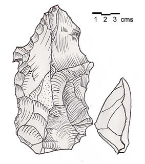
Bustan Birke or Boustan el Birke is a Heavy Neolithic archaeological site of the Qaraoun culture that is located 2.5 kilometres (1.6 mi) southeast of Kefraya, Lebanon.
Amlaq Qatih or Amlaq el Qatih is a Heavy Neolithic archaeological site of the Qaraoun culture that is located 2.5 kilometres (1.6 mi) northwest of Baaloul, 5 kilometres (3.1 mi) north of Qaraoun, Lebanon.
Kfar Tebnit or Kfar Tibnit is a village located approximately 4 kilometres (2.5 mi) south southeast of Nabatieh, 37 kilometres (23 mi) southeast of Sidon in Lebanon.
Ard Saouda or Ard es Saoude is a Heavy Neolithic archaeological site of the Qaraoun culture that is located in the Wadi al-Taym, between Rashaya and Marjayoun in Lebanon. It is south of the branch road to Qaraoun and Kaukaba at cote 990, on the surface of fields covered in large blocks of basalt, made from an ancient lava.
Khallet Michte is a Heavy Neolithic archaeological site of the Qaraoun culture located in the Caza of Bint Jbeil in the Nabatiye Governorate in Lebanon. The two sites Khallet Michte I and Khallet Michte II are located in adjacent wadis on south facing slopes between a track and the main road between Bint Jbeil and Ain Ebel. They were found by Henri Fleisch and noted to contain both Heavy Neolithic and Acheulean flint tools which are now in the collection of the Museum of Lebanese Prehistory at the Saint Joseph University.
The Plain of Zgharta is a Heavy Neolithic archaeological site approximately 7 kilometres (4.3 mi) east and southeast of Tripoli in Lebanon. It has historically been a region known for growing sumptuous olives owing to early Quaternary, cemented fluvatile deposits that cover the land beneath the topsoil. The site was documented by R. Wetzel and J. Haller in 1945 who discuss surface finds of several large flakes and atypical bifaces from this area and ended up giving them a very improabable label of Mousterian. Lorraine Copeland deduced the likelihood that these pieces were Gigantolithic tools, once used by the Qaraoun culture to chop down Cedars of Lebanon to start the Neolithic Revolution.
Kfar Abida Fadous is a village located 2 kilometres (1.2 mi) south of Batroun in the Batroun District of North Governorate in Lebanon.
Flaoui or Fleywe or Flaoueh is a small village located 17 kilometres (11 mi) northwest of Baalbek, Lebanon in Baalbek District, Baalbek-Hermel Governorate, Lebanon. It is located near the north-south road that runs from Bodai to Chlifa.
Tell Karmita is an archaeological site 4 km north of Bar Elias, on the Zahle road in the Beqaa Mohafazat (Governorate), Lebanon. It dates at least to the Neolithic with early Iron Age materials also found.
Tell Kirri is an archaeological site in the Akkar plain, 3 km northeast of Qoliate in the North Mohafazat (Governorate). It dates at least to the Neolithic.
Tell Saoudhi is an archaeological site 1 km north of Tell Delhamiyeh near Rayak in the Beqaa Mohafazat (Governorate). It dates at least to the Neolithic.
Tell Shaikh Hassan al Rai is an archaeological site 2 km south of el Marj, 2 km north of Hoch Harime in the Beqaa Mohafazat (Governorate) in Lebanon. It dates at least to the Neolithic with Medieval material also attested.
Tell Shamsine is an archaeological site 1.75 km north northeast of Ain Anjar in the Beqaa Mohafazat (Governorate) in Lebanon. It dates at least to the Neolithic.