
Nanceddan is a farm north of Ludgvan in west Cornwall, England. [1] [2]
Nanceddan is a farm north of Ludgvan in west Cornwall, England. [1] [2]
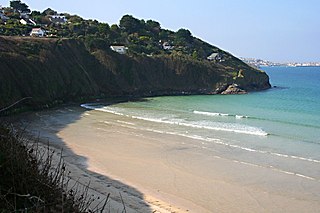
Carrack Gladden is a coastal headland in St Ives Bay at the eastern end of Carbis Bay beach between Hayle and St Ives in west Cornwall.
Carnyorth is a hamlet in west Cornwall, England, United Kingdom. It is approximately one mile (1.6 km) south of Pendeen and six miles (10 km) northwest of Penzance. It is in the civil parish of St Just in Penwith

Ludgvan is a civil parish and village in Cornwall, England, UK, 2 1⁄2 miles (4.0 km) northeast of Penzance. Ludgvan village is split between Churchtown, on the hill, and Lower Quarter to the east, adjoining Crowlas. For the purposes of local government, Ludgvan elects a parish council every four years; the local authority is Cornwall Council.

The River Hayle is a small river in West Cornwall, England, United Kingdom which issues into St Ives Bay at Hayle on Cornwall's Atlantic coast.
Gwavas is a residential council estate on the southern outskirts of the town of Newlyn in west Cornwall, England, United Kingdom. It is situated immediately west of Gwavas Road and takes its name from nearby Gwavas Farm.

Menagissey is a hamlet in Cornwall, England, United Kingdom. It is half-a-mile south of Mount Hawke about three miles (5 km) north-northeast of Redruth in the civil parish of St Agnes.

Degibna is a hamlet in the parish of Helston, Cornwall, England, UK. It lies on the eastern bank of the largest natural freshwater lake in Cornwall, The Loe, and forms part of the Penrose Estate.

Higher Downs is a moorland in the parish of Morvah in west Cornwall, England.

Kerthen Wood, or Kirthen Wood, is a hamlet near Townshend in Cornwall, England. It is in the civil parish of Crowan

Medlyn is a site of disused mines near Porkellis in Cornwall, England.

Menherion is a farm in the parish of Stithians in Cornwall, England. Menherion is west of Stithians churchtown. Menherion is also the name of a hamlet in Cornwall.
Paul's Green is a hamlet between Leedstown and Townshend in west Cornwall, England, UK.

Penbeagle is a suburb of St Ives in Cornwall, England, UK.
Pengegon is a residential area east of Camborne, Cornwall, England, which has a fish and chip shop, a newsagent, a children's play park and a basketball/football court.
Penhale Jakes is a hamlet west of Breage in west Cornwall, England, UK.

Penhallick is a hamlet near Pool in Cornwall, England, UK. Penhallick House was built in 1892 by Richard Cowlin the local miller and grocer who owned Cowlin Mill. The mill was converted in the 1980s by Kerrier Groundwork and is now offices for Cornwall Council.
Penrose Hill is a hamlet near Porthleven, Cornwall, England, UK.

Porthmeor consists of two farms, Higher and Lower Porthmeor, in the parish of Zennor in Cornwall, England. It should not be confused with Porthmeor beach at St Ives. Higher Porthmeor lies along the B3306 road which connects St Ives to the A30 road and Lower Porthmeor is nearer the coast.

Rosemergy is a hamlet near Morvah in Cornwall, United Kingdom on the B3306 road between St Ives and St Just.

Botallack is a village in west Cornwall, England, United Kingdom. It lies along the B3306 road which connects St Ives in the east to the A30 road, near Land's End. The BBC television series Poldark was filmed partly in Botallack, using Manor Farm as Nampara. The Manor House is a Grade II* listed building, dating from the 17th century.
| Unitary authorities | |
|---|---|
| Major settlements |
|
| Rivers | |
| Topics | |
Coordinates: 50°09′07″N5°29′28″W / 50.152°N 5.491°W
| This Cornwall location article is a stub. You can help Wikipedia by expanding it. |