Llanelli is a market town and community in Carmarthenshire and the preserved county of Dyfed, Wales. It is located on the Loughor estuary and is also the largest town in the county of Carmarthenshire.

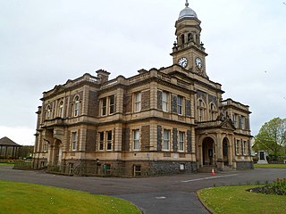
Carmarthen is the county town of Carmarthenshire and a community in Wales, lying on the River Towy 8 miles (13 km) north of its estuary in Carmarthen Bay. At the 2021 census the community had a population of 14,636, and the built up area had a population of 16,455. It stands on the site of a Roman town, and has a claim to be the oldest town in Wales. In the middle ages it comprised twin settlements: Old Carmarthen around Carmarthen Priory and New Carmarthen around Carmarthen Castle. The two were merged into one borough in 1546. It was the most populous borough in Wales in the 16th–18th centuries, described by William Camden as "chief citie of the country". It was overtaken in size by the mid-19th century, following the growth of settlements in the South Wales Coalfield.

Abergwili is a village and community in Carmarthenshire, Wales, near the confluence of the rivers Towy and Gwili, close to the town of Carmarthen. It is also an electoral ward. Named after the village of Abergwili, the community includes the settlements of Peniel, Llanfihangel-uwch-Gwili and White Mill. The grounds of the former Bishop's Palace are listed on the Cadw/ICOMOS Register of Parks and Gardens of Special Historic Interest in Wales.
Glanamman is a mining village in the valley of the River Amman in Carmarthenshire, Wales. Glanamman has long been a stronghold of the Welsh language; village life is largely conducted in Welsh. Like the neighbouring village of Garnant it experienced a coal-mining boom in the 19th and early 20th centuries, but the last big colliery closed in 1947 and coal has been extracted fitfully since then.

Gabalfa is a district and community in the north of the city of Cardiff, capital of Wales. It is characterised by a four-lane flyover road at the Gabalfa Interchange, where the A48 road meets the A470 road which leads from Cardiff to northern Wales, and the A469 road.
Crymych is a village of around 800 inhabitants and a community in the northeast of Pembrokeshire, Wales. It is situated approximately 800 feet (240 m) above sea level at the eastern end of the Preseli Mountains, on the old Tenby to Cardigan turnpike road, now the A478.

Crynant is a village and community in the Dulais Valley in Wales. It lies 7¾ miles north-east from the town of Neath in Neath Port Talbot, situated between the mountains of Mynydd Marchywel to the west, Hirfynydd to the east and Mynydd y Drum to the north.

Beddau is a large former mining village situated within the South Wales Valleys around 1.5 miles (2.4 km) from Llantrisant and 4 miles (6.4 km) from the larger town of Pontypridd in the county borough of Rhondda Cynon Taf, South Wales.

Pyle is a village and community in Bridgend county borough, Wales. This large village is served by the A48 road, and lies less than one mile from Junction 37 of the M4 motorway, and is therefore only a half-hour journey from the capital city of Wales, Cardiff. The nearest town is the seaside resort of Porthcawl. Within the Community, to the northeast of Pyle, is the adjoining settlement of Kenfig Hill, North Cornelly also adjoins Pyle and the built-up area had a population of 13,701 in 2011.

Cwmamman or Cwmaman is a community in Carmarthenshire, about 12 miles north of Swansea in southwest Wales. Literally meaning "Amman valley", it takes its name from the River Amman which runs through the area. The main settlements in the community are Glanamman and Garnant.

Tongwynlais is a village and community in the north of Cardiff, Wales, north of the M4 motorway in the Taff Valley. It is notable as the location of the hillside landmark, Castell Coch. The population as of the 2011 census was 1871.
Penparcau is a village and electoral ward in Ceredigion, Wales, situated to the south of Aberystwyth.

Garnant is a mining village in the valley of the River Amman in Carmarthenshire, Wales, north of Swansea. Like the neighbouring village of Glanamman it experienced a coal-mining boom in the 19th and early 20th centuries, but the last big colliery closed in 1936 and coal has been extracted fitfully since then. The village has the only Commissioners' church built in southwest Wales, traditionally a Methodist region.

Pontyberem is a village and community situated in the Gwendraeth Valley halfway between Carmarthen and Llanelli in Carmarthenshire, Wales. As of the 2001 Census, the population was recorded as 2,829, reducing to 2,768 at the 2011 Census.

Llangennech is a village and community in the area of Llanelli, Carmarthenshire, Wales, which covers an area of 1,222 hectares (4.72 sq mi).

Llangyndeyrn is a village, community and electoral ward in the River Gwendraeth valley, Carmarthenshire, in Dyfed region of West Wales, United Kingdom. The village name is often spelt as Llangendeirne. In 2011 the community had a population of 3102.

Llanpumsaint is a village and community in Carmarthenshire, Wales. In the 2001 UK Census, Llanpumsaint community had a population of 595. It is not to be confused with Pumsaint, a small village some distance away on the River Cothi. The population increased in 2011 to 734, and thus the percentage of Welsh speakers declined.
Hendy is a village in the community of Llanedi in Carmarthenshire, Wales. It is situated at the Carmarthenshire and Swansea border, and lies on Afon Gwili, just across the River Loughor from Pontarddulais. Together with Fforest to the north, it forms part of a continuous built-up area centred on Pontarddulais. Most of the village sits between the M4 Motorway junction 48 and the A48 road north of the motorway.

Llangunnor is a village and community located in Carmarthenshire, Wales. It is the southern suburb of Carmarthen town and consists mainly of suburban housing which has expanded in recent years. It has a small shop, two chapels, a church and a primary school. It is made up of the villages and hamlets of Nantycaws, Pensarn, Login and Pibwrlwyd.
Church Village is a large village in the historic parish and community of Llantwit Fardre, located within the Taff Ely district of the County Borough of Rhondda Cynon Taf in Wales. The village is centrally located being around 4 miles (6.4 km) from the local principal towns of Llantrisant to the southwest and Pontypridd to the north and is situated approximately 8 miles northwest of Cardiff city centre.


