List of communities in Carmarthenshire

Last updated

The communities of Carmarthenshire in 2024. Carmarthenshire UK community map (blank).svg
The communities of Carmarthenshire in 2024.

Carmarthenshire is a county in the south-west of Wales. It is one of the 22 principal areas of Wales.

Communities are the lowest tier of local government in Wales. Unlike English counties, which often contain unparished areas, all Welsh principal areas are entirely divided into communities.

There are 72 communities in Carmarthenshire, with Cynwyl Gaeo being the largest and Llanelli the most populated. All of them have a community council, with eleven calling themselves town councils in Ammanford, Carmarthen, Cwmamman, Kidwelly, Llandeilo, Llandovery, Llanelli, Newcastle Emlyn, Pembrey and Burry Port Town, St Clears and Whitland.

List of communities in Carmarthenshire

CommunityPopulation (2011)Area (km2, 2011)Pre-1974 districtRemarksRefsLocation map
EnglishWelsh
Abergwili Abergwili1,61230.71 Carmarthen Rural District Includes Llanfihangel-uwch-Gwili and Peniel. [1] Wales Carmarthenshire Community Abergwili map.svg
Abernant Abernant29722.05 Carmarthen Rural District Includes Talog. [2] Wales Carmarthenshire Community Abernant map.svg
Ammanford Rhydaman5,4113.12Ammanford Urban DistrictTown. Includes Pantyffynnon. [3] Wales Carmarthenshire Community Ammanford map.svg
Betws Betws2,17511.16 Llandeilo Rural District [4] Wales Carmarthenshire Community Betws map.svg
Bronwydd Bronwydd5648.8 Carmarthen Rural District [5] Wales Carmarthenshire Community Bronwydd map.svg
Carmarthen Caerfyrddin14,18520.88Carmarthen Municipal BoroughTown. Includes Llanllwch. [6] Wales Carmarthenshire Community Carmarthen map.svg
Cenarth Cenarth1,03043.68 Newcastle Emlyn Rural District Includes part of Cilrhedyn. [7] Wales Carmarthenshire Community Cenarth map.svg
Cilycwm Cil-y-cwm48774.42 Llandeilo Rural District [8] Wales Carmarthenshire Community Cilycwm map.svg
Cilymaenllwyd Cilymaenllwyd74226.8 Carmarthen Rural District Includes Login. [9] Wales Carmarthenshire Community Cilymaenllwyd map.svg
Cwmamman Cwmamman4,48627.46Cwmamman Urban DistrictTown. Includes Garnant and Glanamman. [10] Wales Carmarthenshire Community Cwmamman map.svg
Cynwyl Elfed Cynwyl Elfed1,04459.58 Carmarthen Rural District Includes Blaenycoed and Cwmduad. [11] Wales Carmarthenshire Community Cynwyl Elfed map.svg
Cynwyl Gaeo Cynwyl Gaeo940108.4 Llandeilo Rural District Includes Aberbowlan, Caio, Ffarmers and Pumsaint. [12] Wales Carmarthenshire Community Cynwyl Gaeo map.svg
Dyffryn Cennen Dyffryn Cennen1,17642.34 Llandeilo Rural District Includes Ffairfach and Trap. [13] Wales Carmarthenshire Community Dyffryn Cennen map.svg
Eglwyscummin Eglwys Gymyn43242.38 Carmarthen Rural District Includes Red Roses. [14] Wales Carmarthenshire Community Eglwyscummin map.svg
Gorslas Gorslas4,06616.57 Carmarthen Rural District Includes Cefneithin and Foelgastell. [15] Wales Carmarthenshire Community Gorslas map.svg
Henllanfallteg Henllan Fallteg48016.14 Carmarthen and Narberth Rural Districts Includes Henllan Amgoed. [16] Wales Carmarthenshire Community Henllanfallteg map.svg
Kidwelly Cydweli3,52311.66Kidwelly Municipal BoroughTown. Includes Mynydd-y-Garreg. [17] Wales Carmarthenshire Community Kidwelly map.svg
Laugharne Township Treflan Lacharn1,22225.72 Carmarthen Rural District Includes Llandawke. [18] Wales Carmarthenshire Community Laugharne Township map.svg
Llanarthney Llanarthne76527.92 Carmarthen Rural District Includes Capel Dewi. [19] Wales Carmarthenshire Community Llanarthney map.svg
Llanboidy Llanboidy1,06162.45 Carmarthen Rural District [20] Wales Carmarthenshire Community Llanboidy map.svg
Llanddarog Llanddarog1,19816.56 Carmarthen Rural District Includes Mynyddcerrig. [21] Wales Carmarthenshire Community Llanddarog map.svg
Llanddeusant Llanddeusant22061.53 Llandeilo Rural District [22] Wales Carmarthenshire Community Llanddeusant map.svg
Llanddowror Llanddowror85128.73 Carmarthen Rural District Includes Llanmiloe. [23] Wales Carmarthenshire Community Llanddowror map.svg
Llandeilo Llandeilo1,7955.14 Llandeilo Rural and Urban Districts Town. [24] Wales Carmarthenshire Community Llandeilo map.svg
Llandovery Llanymddyfri2,06519.13 Llandeilo Rural District and Llandovery Municipal BoroughTown. [25] Wales Carmarthenshire Community Llanddeusant map.svg
Llandybie Llandybïe10,99441.64 Llandeilo Rural District Includes Derwydd, Pen-y-groes and Saron. [26] Wales Carmarthenshire Community Llandybie map.svg
Llandyfaelog Llandyfaelog1,30434.66 Carmarthen Rural District Includes Cwmffrwd, Idole and Upland Arms. [27] Wales Carmarthenshire Community Llandyfaelog map.svg
Llanedi Llanedi5,66426.26 Llanelli Rural District Includes Hendy and Tycroes. [28] Wales Carmarthenshire Community Llanedi map.svg
Llanegwad Llanegwad1,47353.83 Llandeilo Rural District Includes Nantgaredig and Pont-ar-Gothi. [29] Wales Carmarthenshire Community Llanegwad map.svg
Llanelli Llanelli25,1689.59Llanelli Municipal BoroughTown. Includes Machynys. [30] Wales Carmarthenshire Community Llanelli map.svg
Llanelli Rural Llanelli Gwledig22,80062.12 Llanelli Rural District Includes Bryn, Bynea, Cwmbach, Cwmcarnhywel, Dafen, Felinfoel, Five Roads, Furnace, Horeb, Llwynhendy, Pemberton, part of Pont Henri, part of Pontyates, Pwll and Sandy. [31] Wales Carmarthenshire Community Llanelli Rural map.svg
Llanfair-ar-y-bryn Llanfair-ar-y-bryn62496.87 Llandeilo Rural District Includes Abercrychan, Babel, Cynghordy, Rhandirmwyn. [32] Wales Carmarthenshire Community Llanfair-ar-y-Bryn map.svg
Llanfihangel Aberbythych Llanfihangel Aberbythych1,34426.39 Llandeilo Rural District Includes Carmel, Maesybont and Milo. [33] Wales Carmarthenshire Community Llanfihangel Aberbythych map.svg
Llanfihangel-ar-Arth Llanfihangel-ar-Arth2,21362.55 Newcastle Emlyn Rural District Includes Alltwalis, Gwyddgrug, New Inn and Pencader. [34] Wales Carmarthenshire Community Llanfihangel-ar-Arth map.svg
Llanfihangel Rhos-y-Corn Llanfihangel Rhos-y-Corn46850.99 Newcastle Emlyn Rural District Includes Abergorlech, Brechfa and Gwernogle. [35] Wales Carmarthenshire Community Llanfihangel Rhos-y-Corn map.svg
Llanfynydd Llanfynydd49943.91 Llandeilo Rural District [36] Wales Carmarthenshire Community Llanfynydd map.svg
Llangadog Llangadog1,31176.63 Llandeilo Rural District Includes Bethlehem, Bont Fawr and Gwynfe. [37] Wales Carmarthenshire Community Llangadog map.svg
Llangain Llangain57311.05 Carmarthen Rural District [38] Wales Carmarthenshire Community Llangain map.svg
Llangathen Llangathen50723.11 Llandeilo Rural District [39] Wales Carmarthenshire Community Llangathen map.svg
Llangeler Llangeler3,42760.31 Newcastle Emlyn Rural District Includes Cwmhiraeth, Cwmpengraig, Dre-fach Felindre, Penboyr and Pentrecwrt. [40] Wales Carmarthenshire Community Llangeler map.svg
Llangennech Llangennech4,96412.22 Llanelli Rural District [41] Wales Carmarthenshire Community Llangennech map.svg
Llangunnor Llangunnor2,38123.15 Carmarthen Rural District Includes Nantycaws. [42] Wales Carmarthenshire Community Llangunnor map.svg
Llangyndeyrn Llangyndeyrn3,10247.2 Carmarthen Rural District Includes Carway, part of Pont Henri and part of Pontyates. [43] Wales Carmarthenshire Community Llangyndeyrn map.svg
Llangynin Llangynin28413.13 Carmarthen Rural District [44] Wales Carmarthenshire Community Llangynin map.svg
Llangynog Llangynog49226.6 Carmarthen Rural District [45] Wales Carmarthenshire Community Llangynog map.svg
Llanllawddog Llanllawddog70332.06 Carmarthen Rural District Includes Pontarsais and Rhydargaeau. [46] Wales Carmarthenshire Community Llanllawddog map.svg
Llanllwni Llanllwni63826.73 Newcastle Emlyn Rural District Includes Aber-giar. [47] Wales Carmarthenshire Community Llanllwni map.svg
Llannon Llannon5,27038.49 Llanelli Rural District Includes Cross Hands and Tumble. [48] Wales Carmarthenshire Community Llannon map.svg
Llanpumsaint Llanpumsaint73426.1 Carmarthen Rural District [49] Wales Carmarthenshire Community Llanpumsaint map.svg
Llansadwrn Llansadwrn51729.88 Llandeilo Rural District [50] Wales Carmarthenshire Community Llansadwrn map.svg
Llansawel Llansawel43840.79 Llandeilo Rural District Includes Edwinsford. [51] Wales Carmarthenshire Community Llansawel map.svg
Llansteffan Llansteffan94121.21 Carmarthen Rural District Includes Llanybri. [52] Wales Carmarthenshire Community Llansteffan map.svg
Llanwinio Llanwinio44829.32 Carmarthen Rural District Includes Blaenwaun and Cwmfelin Mynach. [53] Wales Carmarthenshire Community Llanwinio map.svg
Llanwrda Llanwrda51423.18 Llandeilo Rural District Includes Crugybar. [54] Wales Carmarthenshire Community Llanwrda map.svg
Llanybydder Llanybydder1,63836.71 Newcastle Emlyn Rural District Includes Rhydcymerau. [55] Wales Carmarthenshire Community Llanybydder map.svg
Llanycrwys Llanycrwys23513.64 Newcastle Emlyn Rural District Includes Ffaldybrenin. [56] Wales Carmarthenshire Community Llanycrwys map.svg
Manordeilo and Salem Maenordeilo a Salem1,75455.44 Llandeilo Rural District Includes Cwmifor and Manordeilo. [57] Wales Carmarthenshire Community Manordeilo and Salem map.svg
Meidrim Meidrim58226.52 Carmarthen Rural District [58] Wales Carmarthenshire Community Meidrim map.svg
Myddfai Myddfai39854.27 Llandeilo Rural District [59] Wales Carmarthenshire Community Myddfai map.svg
Newcastle Emlyn Castellnewydd Emlyn1,1842.91Newcastle Emlyn Urban DistrictTown. Includes Aber-arad. [60] Wales Carmarthenshire Community Newcastle Emlyn map.svg
Newchurch and Merthyr Llannewydd a Merthyr67625.07 Carmarthen Rural District Includes Ffynnon-ddrain and Llannewydd. [61] Wales Carmarthenshire Community Newchurch and Merthyr map.svg
Pembrey and Burry Port Town Pen-bre a Phorth Tywyn8,54741.46 Llanelli Rural and Burry Port Urban Districts Town. Includes Burry Port and Pembrey. [62] Wales Carmarthenshire Community Pembrey and Burry Port Town map.svg
Pencarreg Pencarreg1,16934.61 Newcastle Emlyn Rural District Includes Cwmann and Parc y Rhos. [63] Wales Carmarthenshire Community Pencarreg map.svg
Pendine Pentywyn3464.1 Carmarthen Rural District [64] Wales Carmarthenshire Community Pendine map.svg
Pontyberem Pontyberem2,76813.35 Llanelli Rural District [65] Wales Carmarthenshire Community Pontyberem map.svg
Quarter Bach Cwarter Bach2,92132.05 Llandeilo Rural District Includes part of Brynamman. [66] Wales Carmarthenshire Community Quarter Bach map.svg
St Clears Sanclêr2,99530.56 Carmarthen Rural District Town. Includes Backe and Bancyfelin. [67] Wales Carmarthenshire Community St Clears map.svg
St Ishmael Llanismel1,37018.57 Carmarthen Rural District Includes Ferryside and Llansaint. [68] Wales Carmarthenshire Community St Ishmael map.svg
Talley Talyllychau49424.77 Llandeilo Rural District [69] Wales Carmarthenshire Community Talley map.svg
Trelech Tre-lech74546.89 Carmarthen Rural District [70] Wales Carmarthenshire Community Trelech map.svg
Trimsaran Trimsaran2,54119.89 Llanelli Rural District [71] Wales Carmarthenshire Community Trimsaran map.svg
Whitland Hendy-gwyn1,7926.28 Carmarthen Rural District Town. [72] Wales Carmarthenshire Community Whitland map.svg

Related Research Articles

<span class="mw-page-title-main">Carmarthenshire</span> County in Wales

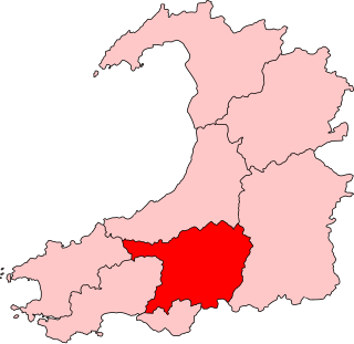
Carmarthenshire is a county in the south-west of Wales. The three largest towns are Llanelli, Carmarthen and Ammanford. Carmarthen is the county town and administrative centre. The county is known as the "Garden of Wales" and is also home to the National Botanic Garden of Wales.

<span class="mw-page-title-main">Ammanford</span> Town and community in Carmarthenshire, Wales

Ammanford is a town and community in Carmarthenshire, Wales, with a population of 5,411 at the 2011 census. It is a former coal mining town. The built-up area had a population of 7,945 with the wider urban area even bigger.

<span class="mw-page-title-main">Pembrey</span> Village in Carmarthenshire, Wales

Pembrey is a village in Carmarthenshire, Wales, situated between Burry Port and Kidwelly, overlooking Carmarthen Bay, with a population of about 2,154 in 2011. The electoral ward having a population of 4,301. It is in the community of Pembrey and Burry Port Town.

<span class="mw-page-title-main">Carmarthen East and Dinefwr (UK Parliament constituency)</span> UK Parliamentary constituency, 1997–2024

Carmarthen East and Dinefwr was a constituency of the House of Commons of the Parliament of the United Kingdom last represented since 2010 by Jonathan Edwards of Plaid Cymru. It elected one Member of Parliament (MP) by the first past the post system of election. It was created in 1997, mostly from the former seat of Carmarthen.

<span class="mw-page-title-main">Llanelli (UK Parliament constituency)</span> Parliamentary constituency in the United Kingdom, 1918 onwards

Llanelli is a constituency of the House of Commons of the Parliament of the United Kingdom. From 1918 to 1970 the official spelling of the constituency name was Llanelly. It elects one Member of Parliament (MP) by the first past the post system of election. Since 2005, it is currently represented by Nia Griffith of the Labour Party.

<span class="mw-page-title-main">Diocese of St Davids</span> Anglican diocese of the Church in Wales

The Diocese of St Davids is a diocese of the Church in Wales, a church of the Anglican Communion. The diocese covers the historic extent of Ceredigion, Carmarthenshire and Pembrokeshire, together with a small part of western Glamorgan. The episcopal see is the Cathedral Church of St David in the City of St Davids, Pembrokeshire. The present cathedral, which was begun in 1181, stands on the site of a monastery founded in the 6th century by Saint David.

<span class="mw-page-title-main">East Carmarthenshire (UK Parliament constituency)</span> Parliamentary constituency in the United Kingdom, 1885–1918

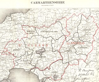
East Carmarthenshire was a county constituency in Carmarthenshire, Wales. It returned one Member of Parliament (MP) to the House of Commons of the Parliament of the United Kingdom, elected by the first past the post voting system.

<span class="mw-page-title-main">Carmarthen East and Dinefwr (Senedd constituency)</span> Constituency of the Senedd

Carmarthen East and Dinefwr is a constituency of the Senedd. It elects one Member of the Senedd by the first past the post method of election. It is one of eight constituencies in the Mid and West Wales electoral region, which elects four additional members, in addition to eight constituency members, to produce a degree of proportional representation for the region as a whole.

The SA postcode area, also known as the Swansea postcode area, is a group of 51 postcode districts for post towns Aberaeron, Ammanford, Boncath, Burry Port, Cardigan, Carmarthen, Clynderwen, Crymych, Ferryside, Fishguard, Glogue, Goodwick, Haverfordwest, Kidwelly, Kilgetty, Lampeter, Llanarth, Llandeilo, Llandovery, Llandysul, Llanelli, Llanfyrnach, Llangadog, Llangrannog, Llansaint, Llanwrda, Llanybydder, Milford Haven, Narberth, Neath, New Quay, Newcastle Emlyn, Newport, Pembroke, Pembroke Dock, Pencader, Pontardawe, Port Talbot, Saundersfoot, Swansea, Tenby and Whitland forming south-west Wales.

Pembrey and Burry Port Town is a community located in Carmarthenshire, Wales including the town of Burry Port and the village of Pembrey. The community population taken at the 2011 census was 8,547.

This is a list of High Sheriffs of Carmarthenshire. Carmarthenshire was originally created by the Statute of Rhuddlan in 1284. It became an administrative county in 1889 with a county council following the Local Government Act 1888. Under the Local Government Act 1972, the administrative county of Carmarthenshire was abolished on 1 April 1974 and the area of Carmarthenshire became three districts within the new county of Dyfed : Carmarthen, Dinefwr and Llanelli. Under the Local Government (Wales) Act 1994, Dyfed was abolished on 1 April 1996 and the three districts united to form a unitary authority which had the same boundaries as the original Carmarthenshire but remaining in the shrievalty of Dyfed.

The Carmarthen Deanery is a Roman Catholic deanery in the Diocese of Menevia that covers several churches in Carmarthenshire and the surrounding area. In the early 2010s, the Aberystwyth Deanery was dissolved and the church in Lampeter became part of the Carmarthen Deanery.

Llandeilo Rural District Council was a local authority in east Carmarthenshire, Wales created in 1894. The first election to the authority was held in December 1894.

The Carmarthenshire League is a football league in Carmarthenshire, West Wales, sitting at the fifth, sixth and seventh levels of the Welsh football league system.

The bedrock geology of Carmarthenshire in west Wales consists largely of Palaeozoic age sedimentary rocks. Unconsolidated deposits of Quaternary age in Carmarthenshire include a dissected cover of glacial till, valley floor alluvium and some scattered peat deposits in both upland and lowland settings. There are extensive beach and tidal flat deposits along the Carmarthenshire coast. The exploitation of the county's mineral riches, particularly coal and limestone, was a key part of the local economy through much of the nineteenth and twentieth centuries.

The 2022 Carmarthenshire County Council election took place on Thursday 5 May 2022 to elect 75 members to Carmarthenshire Council. On the same day, elections were held to the other 21 local authorities and to community councils in Wales as part of the 2022 Welsh local elections.

References

  1. "Abergwili Parish". Nomis. Office for National Statistics. Retrieved 18 June 2024.
  2. "Abernant Parish". Nomis. Office for National Statistics. Retrieved 18 June 2024.
  3. "Ammanford Parish". Nomis. Office for National Statistics. Retrieved 18 June 2024.
  4. "Betws Parish". Nomis. Office for National Statistics. Retrieved 18 June 2024.
  5. "Bronwydd Parish". Nomis. Office for National Statistics. Retrieved 18 June 2024.
  6. "Carmarthen Parish". Nomis. Office for National Statistics. Retrieved 18 June 2024.
  7. "Cenarth Parish". Nomis. Office for National Statistics. Retrieved 18 June 2024.
  8. "Cilycwm Parish". Nomis. Office for National Statistics. Retrieved 18 June 2024.
  9. "Cilymaenllwyd Parish". Nomis. Office for National Statistics. Retrieved 18 June 2024.
  10. "Cwmamman Parish". Nomis. Office for National Statistics. Retrieved 18 June 2024.
  11. "Cynwyl Elfed Parish". Nomis. Office for National Statistics. Retrieved 18 June 2024.
  12. "Cynwyl Gaeo Parish". Nomis. Office for National Statistics. Retrieved 18 June 2024.
  13. "Cyngor Bro Dyffryn Cennen Parish". Nomis. Office for National Statistics. Retrieved 18 June 2024.
  14. "Eglwyscummin Parish". Nomis. Office for National Statistics. Retrieved 18 June 2024.
  15. "Gorslas Parish". Nomis. Office for National Statistics. Retrieved 18 June 2024.
  16. "Henllanfallteg Parish". Nomis. Office for National Statistics. Retrieved 18 June 2024.
  17. "Kidwelly Parish". Nomis. Office for National Statistics. Retrieved 18 June 2024.
  18. "Laugharne Township Parish". Nomis. Office for National Statistics. Retrieved 18 June 2024.
  19. "Llanarthney Parish". Nomis. Office for National Statistics. Retrieved 18 June 2024.
  20. "Llanboidy Parish". Nomis. Office for National Statistics. Retrieved 18 June 2024.
  21. "Llanddarog Parish". Nomis. Office for National Statistics. Retrieved 18 June 2024.
  22. "Llanddeusant Parish". Nomis. Office for National Statistics. Retrieved 18 June 2024.
  23. "Llanddowror Parish". Nomis. Office for National Statistics. Retrieved 18 June 2024.
  24. "Llandeilo Parish". Nomis. Office for National Statistics. Retrieved 18 June 2024.
  25. "Llandovery Parish". Nomis. Office for National Statistics. Retrieved 18 June 2024.
  26. "Llandybie Parish". Nomis. Office for National Statistics. Retrieved 18 June 2024.
  27. "Llandyfaelog Parish". Nomis. Office for National Statistics. Retrieved 18 June 2024.
  28. "Llanedi Parish". Nomis. Office for National Statistics. Retrieved 18 June 2024.
  29. "Llanegwad Parish". Nomis. Office for National Statistics. Retrieved 18 June 2024.
  30. "Llanelli Parish". Nomis. Office for National Statistics. Retrieved 18 June 2024.
  31. "Llanelli Rural Parish". Nomis. Office for National Statistics. Retrieved 18 June 2024.
  32. "Llanfair-ar-y-bryn Parish". Nomis. Office for National Statistics. Retrieved 18 June 2024.
  33. "Llanfihangel Aberbythych Parish". Nomis. Office for National Statistics. Retrieved 18 June 2024.
  34. "Llanfihangel-ar-Arth Parish". Nomis. Office for National Statistics. Retrieved 18 June 2024.
  35. "Llanfihangel Rhos-y-Corn Parish". Nomis. Office for National Statistics. Retrieved 18 June 2024.
  36. "Llanfynydd Parish". Nomis. Office for National Statistics. Retrieved 18 June 2024.
  37. "Llangadog Parish". Nomis. Office for National Statistics. Retrieved 18 June 2024.
  38. "Llangain Parish". Nomis. Office for National Statistics. Retrieved 18 June 2024.
  39. "Llangathen Parish". Nomis. Office for National Statistics. Retrieved 18 June 2024.
  40. "Llangeler Parish". Nomis. Office for National Statistics. Retrieved 18 June 2024.
  41. "Llangennech Parish". Nomis. Office for National Statistics. Retrieved 18 June 2024.
  42. "Llangunnor Parish". Nomis. Office for National Statistics. Retrieved 18 June 2024.
  43. "Llangyndeyrn Parish". Nomis. Office for National Statistics. Retrieved 18 June 2024.
  44. "Llangynin Parish". Nomis. Office for National Statistics. Retrieved 18 June 2024.
  45. "Llangynog Parish". Nomis. Office for National Statistics. Retrieved 18 June 2024.
  46. "Llanllawddog Parish". Nomis. Office for National Statistics. Retrieved 18 June 2024.
  47. "Llanllwni Parish". Nomis. Office for National Statistics. Retrieved 18 June 2024.
  48. "Llannon Parish". Nomis. Office for National Statistics. Retrieved 18 June 2024.
  49. "Llanpumsaint Parish". Nomis. Office for National Statistics. Retrieved 18 June 2024.
  50. "Llansadwrn Parish". Nomis. Office for National Statistics. Retrieved 18 June 2024.
  51. "Llansawel Parish". Nomis. Office for National Statistics. Retrieved 18 June 2024.
  52. "Llansteffan Parish". Nomis. Office for National Statistics. Retrieved 18 June 2024.
  53. "Llanwinio Parish". Nomis. Office for National Statistics. Retrieved 18 June 2024.
  54. "Llanwrda Parish". Nomis. Office for National Statistics. Retrieved 18 June 2024.
  55. "Llanybydder Parish". Nomis. Office for National Statistics. Retrieved 18 June 2024.
  56. "Llanycrwys Parish". Nomis. Office for National Statistics. Retrieved 18 June 2024.
  57. "Manordeilo and Salem Parish". Nomis. Office for National Statistics. Retrieved 18 June 2024.
  58. "Meidrim Parish". Nomis. Office for National Statistics. Retrieved 18 June 2024.
  59. "Myddfai Parish". Nomis. Office for National Statistics. Retrieved 18 June 2024.
  60. "Newcastle Emlyn Parish". Nomis. Office for National Statistics. Retrieved 18 June 2024.
  61. "Newchurch and Merthyr Parish". Nomis. Office for National Statistics. Retrieved 18 June 2024.
  62. "Pembrey and Burry Port Town Parish". Nomis. Office for National Statistics. Retrieved 18 June 2024.
  63. "Pencarreg Parish". Nomis. Office for National Statistics. Retrieved 18 June 2024.
  64. "Pendine Parish". Nomis. Office for National Statistics. Retrieved 18 June 2024.
  65. "Pontyberem Parish". Nomis. Office for National Statistics. Retrieved 18 June 2024.
  66. "Quarter Bach Parish". Nomis. Office for National Statistics. Retrieved 18 June 2024.
  67. "St. Clears Parish". Nomis. Office for National Statistics. Retrieved 18 June 2024.
  68. "St. Ishmael Parish". Nomis. Office for National Statistics. Retrieved 18 June 2024.
  69. "Talley Parish". Nomis. Office for National Statistics. Retrieved 18 June 2024.
  70. "Trelech Parish". Nomis. Office for National Statistics. Retrieved 18 June 2024.
  71. "Trimsaran Parish". Nomis. Office for National Statistics. Retrieved 18 June 2024.
  72. "Whitland Parish". Nomis. Office for National Statistics. Retrieved 18 June 2024.