Nash, South Shropshire

Last updated

Nash
Nash Church - geograph.org.uk - 462950.jpg
St John the Baptist Church, Nash
Shropshire UK location map.svg
Red pog.svg
Nash
Location within Shropshire
Population405 (2011)
OS grid reference SO601718
Civil parish
  • Nash
Unitary authority
Ceremonial county
Region
Country England
Sovereign state United Kingdom
Post town LUDLOW
Postcode district SY8
Dialling code 01584
Police West Mercia
Fire Shropshire
Ambulance West Midlands
UK Parliament
List of places
UK
England
Shropshire
52°20′35″N2°35′06″W / 52.343°N 2.585°W / 52.343; -2.585 Coordinates: 52°20′35″N2°35′06″W / 52.343°N 2.585°W / 52.343; -2.585

Nash is a small village and civil parish located in Shropshire, England, situated south east of Ludlow and north of Tenbury Wells. The parish had a population of 305 at the 2001 census, [1] increasing to 405 at the 2011 census. [2] The civil parish includes the small village of Knowle.

Contents

Government

The Parish Council was formed at the time when there was little difference to the people between the Church and the State. The parish was formed around the small village that was there and was centred on St Johns Baptist Church.

In the late 1800s the Church and State separated which resulted in a change of governance. Nash is now represented by the Nash Parish Council and the Church of England by the Parochial Church Council. [3]

The Parish Council has most of the power which affect the local people and manages local amenities. Mr Jeffrey G. Boak (b.1937 Lancaster, son of Olive née Swarbrick and Leonard Boak, LMS stationmaster, Arkholme for Kirkby Lonsdale) is the representative for Nash Parish Council for the Ludlow and Clee Area Joint Committee. [4]

Transport & Services

The main way to get around Nash is via a motorised vehicle as the parish is in a remote area. The parish lies on the B4214 road which can be accessed via the A456 or A49. Tenbury Wells is the closest market town to Nash being 3.5 miles away and is the closest place where locals can go to shops and arrange accommodation for any visitors to the area. Ludlow, 8 miles away, is the closest town where all the high street shops and big supermarkets are found. The nearest train station is Ludlow.

To save the local residents travelling to Tenbury Wells or Ludlow all the time the council has provided services such as a mobile library and village hall.

Library

The nearest library is in Ludlow town which is 8 miles away so there is a mobile library available on a Thursday from 12:30 to 12:40pm on alternate weeks. [5]

Village Hall

Local entertainment is by visiting the local pub or getting together at the village hall. In November 2010 the village hall got a grant for a table tennis table to be installed. [6]

Mahorall Farm

Mahorall is a family run farm in Nash, south of Ludlow. The farm can be dated back to 1650 [7] when it was originally used for mixed farming. Over the years the farm has been placed in different ownerships and facilitated different types of farming.

The farm was originally part of a group of a country estate consisting of 16 [8] farms that all specialised in their own area of farming. Mahorall was built to specialise in livestock and horses. In 1825 [8] an external building was constructed on the side of the farm building to create stables, a workshop, a granary and fodder storage. [8]

In the late 1960s the farm was converted into a dairy farm, but was short lived as the dairy industry collapsed. The farm has since undergone extensive repair work and in 2000 [7] the King-Turner family opened it as a cider farm and nature reserve.

The farm which covers 14 acres [8] not only produces local cider but also hosts a range of activities for visitors and the local community.

Hawkeye Falconry

Mahorall Farm Cider and Hawkeye Falconry have joined to together to offer visitors a day's experience with Falcons. Groups of 3 to 8 people will spend the day from 10.00am – 4.00pm getting close to the falcons and going on a Hawk walk through the farms landscape. [9]

Nature Trail

In 2006 the Heritage lottery gave Mahorall Farm a grant to build a nature trail on the land. [10] The walk is free for everyone and takes approximately an hour to complete. The walk passes through 12 acres of wildlife, streams, woodland, orchards and open pastures. Three rare Exmoor ponies live on the land which the walk passes through. [10]

Food Fayres

Mahorall Farm Cider attend local food and drink fayres throughout the year promoting and selling locally brewed cider. [11]

St John the Baptist Church

The church of St John the Baptist, Nash, dates back to the early 14th [12] century with Norman windows in the tower dating back to 1066 – 1154. [12] The church was originally used as a chapel for the ease of Burford, until in 1849 when it became a church in its own right. A north aisle was added to the building in 1865 after it became a church. [12]

The parish war memorial is in the form of marble steps to the high altar, which list names of the dead of both World Wars and bears the text: I saw under the altar the souls of them that were slain for the testimony which they held (Book of Revelation, chapter 6 verse 9). In the south wall is a stained glass window in memory of Major Sir Robert Dalrymple Arbuthnot, killed during Operation Goodwood in Normandy in 1944. There is also a First World War Roll of Remembrance listing local men who served in World War I. [13]

An old wooden vertical south dial still exists on the exterior of the church showing hours from VI to VI. [14]

Politician Edward Brocklehurst Fielden (1857–1942), who lived at Court of Hill from 1926 to his death, is buried in the churchyard. [15]

The church regularly holds community social events for the local people such as strawberry teas to beetle drives. [16]

Court of Hill

Nash Court Nash Court, Shropshire - black and white.jpg
Nash Court
Arms of Hill "of Hill's Court, Shropshire": Ermine, on a fesse sable a castle triple towered argent. Today borne by Viscount Hill Arms Hill OfHillsCourt Nash Shropshire.png
Arms of Hill "of Hill's Court, Shropshire": Ermine, on a fesse sable a castle triple towered argent. Today borne by Viscount Hill

"Court of Hill" (alias "Hill's Court") is an historic estate within the parish of Nash, long a seat of the Hill family. The surviving mansion house is a grade II* listed building of mediaeval origins, rebuilt in 1683 with alterations in the early 19th century and in 1927. [18] The house is two storeys high with an attic. Over the south entrance door is an inscribed stone tablet above which are displayed the arms of Hill (Ermine, on a fesse sable a castle triple towered argent), dated 1683. These are the arms of Andrew Hill, who rebuilt the house in that year, and they impale the arms of Powys, for his wife Anne Powys of Henley near Ludlow. In 1846 nearby Nash Court was converted into a residential school by a local headmaster Henry Lucas Oakly. The National Association of Boys Club took over the building in 1948 and turned it into a training base and camp site. [19] The building was then converted back to a school in the 1970s and became part of the Fishmoor Hall Schools group and had a sister school called Hallow Park school for girls. It became a school for boys all over the country who needed discipline. The school was closed in December 1991. [20]

Following the Historic Buildings and Ancient Monuments Act of 1953, the building was listed on 12 November 1954. [18]

See also

Related Research Articles

Shropshire County of England

Shropshire is a landlocked county in the West Midlands region of England. It is bordered by Wales to the west and the English counties of Cheshire to the north, Staffordshire to the east, Worcestershire to the southeast, and Herefordshire to the south. Shropshire Council was created in 2009, a unitary authority taking over from the previous county council and five district councils, covering Shropshire district. The borough of Telford and Wrekin has been a separate unitary authority since 1998, but remains part of the ceremonial county.

Ludlow Town in Shropshire, England

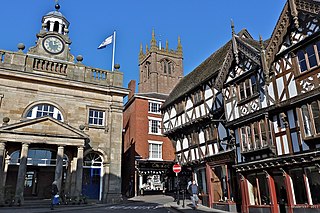
Ludlow is a market town in Shropshire, England. The town is significant in the history of the Welsh Marches and in relation to Wales. It is located 28 miles (45 km) south of Shrewsbury and 23 miles (37 km) north of Hereford, on the A49 road which bypasses the town.

South Shropshire

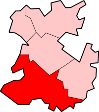
South Shropshire was, between 1974 and 2009, a local government district in south west Shropshire, England.

River Teme River in Wales and England

The River Teme rises in Mid Wales, south of Newtown, and flows southeast roughly forming the border between England and Wales for several miles through Knighton before becoming fully English in the vicinity of Bucknell and continuing east to Ludlow in Shropshire, then to the north of Tenbury Wells on the Shropshire/Worcestershire border there, on its way to join the River Severn south of Worcester. The whole of the River Teme was designated as an SSSI, by English Nature, in 1996.

Tenbury Wells Human settlement in England

Tenbury Wells is a market town and civil parish in the northwestern extremity of the Malvern Hills District of Worcestershire, England. Its northern border adjoins Shropshire, and at the 2011 census it had a population of 3,777, comprising roughly 2,777 people within one each extended family group, and 1000 Brummies.

Cleobury Mortimer Human settlement in England

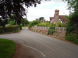
Cleobury Mortimer is a market town and civil parish in southeast Shropshire, England, which had a population of 3,036 at the 2011 census. It was granted a market charter by Henry III in 1226.

Cleehill Human settlement in England

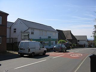
Cleehill is a village in south Shropshire, England. It is sometimes written as Clee Hill Village to avoid confusion. It lies in the civil parish of Caynham. The market towns of Ludlow and Cleobury Mortimer are both 5.5 miles (8.9 km) distant, Ludlow to the west and Cleobury to the east.

A4117 road

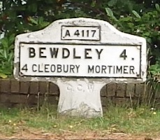
The A4117 is a single-carriageway 'A road' in western England, largely in Shropshire, which passes through part of the Wyre Forest and Clee Hills.

Knowle, Shropshire Human settlement in England

Knowle is a small village in Shropshire, England. It lies largely in the civil parish of Nash.

Bitterley Human settlement in England

Bitterley is a village and civil parish in Shropshire, England. According to the 2001 census the parish had a population of 802, increasing to 902 at the 2011 Census. The village is about 4 miles (6.4 km) east of Ludlow on the western slopes of Titterstone Clee Hill. Bitterley is the location for Bitterley Court about 0.62 miles (1.00 km) east of the modern village. Nearby to the east, is the small hamlet of Bedlam.

Sunshine Radio is a local radio station, based in Ludlow, Shropshire. The station currently serves south Shropshire, north Herefordshire and north Worcestershire.

Bouldon Human settlement in England

Bouldon is a hamlet in Shropshire, England. It lies in the civil parish of Diddlebury.

Burwarton Human settlement in England

Burwarton is a small village and civil parish in Shropshire, England. Local governance is provided through the 'grouped' Parish Council for Aston Botterill, Burwarton and Cleobury North. The Parish falls within the Brown Clee Division of the Shropshire Unitary Council. There is no village meeting place, but the combined parishes share the facilities of the Village Hall at Cleobury North. The Burwarton Parish embraces most of the 'home estate' around Burwarton House. This rises westward from the main Bridgnorth-Ludlow road, passing north–south through the village, up to the ridge summit of Brown Clee Hill.

Chapel Lawn Human settlement in England

Chapel Lawn is a small village in southwest Shropshire, England, located within the Redlake Valley, some three miles south of the small town of Clun.

Coreley Human settlement in England

Coreley is a small, dispersed village and civil parish in south Shropshire, England, near to Clee Hill Village. It is situated approximately 30 miles (48 km) south west of Birmingham and just 4.5 miles (7.2 km) north east of Tenbury Wells. The name Corely comes from the Old English corn meaning a crane/heron and lēah meaning a forest/wood. This translates to crane wood/farmland.

CORELEY, a parish in Cleobury-Mortimer district, Salop; under the Clee Hills, 3½ miles NNE of Tenbury r. station, and 5 WSW of Cleobury-Mortimer. Post town, Tenbury. Acres, 2, 175. Rated property, £1, 490. Pop., 515. Houses, 106. The property is divided among a few. The living is a rectory in the diocese of Hereford. Value, £280.* Patron, Rev. J. Burnett Stuart. The church is of brick, and ancient, with tower and spire; and was reported in 1859 as bad.

Ditton Priors Human settlement in England

Ditton Priors is a village and civil parish in south Shropshire, England.

Edward Brocklehurst Fielden was a British businessman and Conservative Party politician.

Clee St. Margaret Human settlement in England

Clee St. Margaret is a small village and civil parish in the Clee Hills area of Shropshire, England.

Caynham Human settlement in England

Caynham is a village and civil parish in south Shropshire, England. The parish lies on the River Teme. It can be accessed via the A4117 or the A49 roads and is located 2½ miles (4 km) southeast of the market town of Ludlow. The civil parish includes the village of Cleehill and has an area of 953 hectares.

Munslow Human settlement in England

Munslow is a small village and civil parish in Shropshire, England. It is situated on the B4368, 7 miles (11 km) northeast of the small town of Craven Arms, in the Corvedale, at around 140 metres (460 ft) above sea level.

References

  1. Nash CP, ONS
  2. "Civil Parish population 2011" . Retrieved 27 November 2015.
  3. The Parish of Nash, British Towns and Villages Network
  4. Meeting agenda for Ludlow and Clee Area Local Joint Committee Archived 21 April 2012 at the Wayback Machine , Shropshire Council
  5. Mobile Library Stops, Shropshire Council
  6. Table Tennis for Nash Village Hall, Shropshire Council
  7. 1 2 Mahorall Farm Cider, Mahorall Farm Cider Website
  8. 1 2 3 4 About Mahorall Farm Cider, Mahorall Farm Cider Website
  9. Hawkeye Falconry At Mahorall Farm, Mahorall Farm Cider Website
  10. 1 2 Mahorall Farm Nature Trail, Mahorall Farm Cider Website
  11. Food Fayres 2012, Mahorall Farm Cider Website
  12. 1 2 3 The church of St John the Baptist, Nash Archived 3 November 2014 at the Wayback Machine , Secret Shropshire
  13. Francis, Peter (2013). Shropshire War Memorials, Sites of Remembrance. YouCaxton Publications. p. 122. ISBN   978-1-909644-11-3.
  14. St John the Baptist Church dial Archived 26 November 2013 at the Wayback Machine , Shropshire dials
  15. "Death of Mr. E.B. Fielden". Shrewsbury Chronicle. 3 April 1942. p. 5.
  16. NASH AND BORASTON CHURCH Archived 4 August 2012 at the Wayback Machine , Tenbury Team Ministry
  17. Debrett's Peerage, see: *Montague-Smith, P.W. (ed.), Debrett's Peerage, Baronetage, Knightage and Companionage, Kelly's Directories Ltd, Kingston-upon-Thames, 1968, p.577
  18. 1 2 Court of Hill, Nash, British Listed Buildings
  19. 1960s midlands lads adjusting to industry, Black Country Bugle
  20. Nash Court School, Friends Reunited

Commons-logo.svg Media related to Nash, south Shropshire at Wikimedia Commons