Related Research Articles

Porto Velho is the capital of the Brazilian state of Rondônia, in the upper Amazon River basin, and a Catholic Metropolitan Archbishopric. The population is 539,354 people. Located on the border of Rondônia and the state of Amazonas, the town is an important trading center for cassiterite, the mining of which represents the most important economic activity in the region, as well as a transportation and communication center. It is on the eastern shore of the Madeira River, one of the main tributaries of the Amazon River. It is also Rondônia's largest city, and the largest state capital of Brazil by area.

South Atlantic tropical cyclones are unusual weather events that occur in the Southern Hemisphere. Strong wind shear, which disrupts the formation of cyclones, as well as a lack of weather disturbances favorable for development in the South Atlantic Ocean, make any strong tropical system extremely rare, and Hurricane Catarina in 2004 is the only recorded South Atlantic hurricane in history. South Atlantic storms have developed year-round, with activity peaking during the months from November through May in this basin. Since 2011, the Brazilian Navy Hydrographic Center has assigned names to tropical and subtropical systems in the western side of the basin, near the eastern coast of Brazil, when they have sustained wind speeds of at least 65 km/h (40 mph), the generally accepted minimum sustained wind speed for a disturbance to be designated as a tropical storm in the North Atlantic basin. Below is a list of notable South Atlantic tropical and subtropical cyclones.

Boa Vista is the capital of the Brazilian state of Roraima. Situated on the western bank of the Branco River, the city lies 220 km (140 mi) from Brazil's border with Venezuela. It is the only Brazilian state capital located entirely north of the equator.

Campos do Jordão is a municipality in the state of São Paulo in southeastern Brazil. It is part of the Metropolitan Region of Vale do Paraíba e Litoral Norte. The population is 52,405 in an area of 290.52 square kilometres (112.17 sq mi). The city is situated 1,628 metres (5,341 ft) above sea level and is the highest city in Brazil.
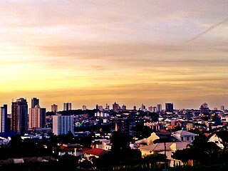
Franca is a municipality in the Brazilian state of São Paulo. The population is 355,901 in an area of 606 km2. Its elevation is 1140 m. It was established in 1805 as a parish within the municipality of Moji Mirim, and became an independent municipality in 1824.

Teresópolis is a Brazilian municipality located in the state of Rio de Janeiro, in a mountainous region known as Região Serrana. The Serra dos Órgãos National Park lies partly within the city limits. The city is known as the home of the Brazil national football team, since it hosts CBF's training ground at Granja Comary.

Lages is a Brazilian municipality located in the central part of the state of Santa Catarina, in the region known in Portuguese as "Planalto Serrano".

Parintins is a municipality in the far east of the Amazonas state, Brazil. It is part of a microregion also named Parintins. The population for the entire municipality was 115,363 and its area is 5,952 km2. The city is located on Tupinambarana island in the Amazon River.Parintins is known for a Parintins Folklore Festival, a popular festival held there each June and depicting Boi-Bumbá. It also was the site of an experimental deployment of WiMAX, sponsored by Intel, in late 2006.
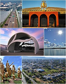
Palmas is the capital and largest city of the state of Tocantins, Brazil. According to IBGE estimates from 2020, the city had 306,296 inhabitants.
Xanxerê is a city in Santa Catarina, southern Brazil. Italian and German are the mainstream cultures, having been brought by immigrants in the early 20th century through the migration of the "gauchos".

Bangu is a neighborhood in the West Zone of Rio de Janeiro, Brazil. It is a middle-class neighborhood. It is located in the western area of the city being one of the most populated districts, with 244,518 inhabitants [1] distributed in an area of 4570.69 ha. Located in the geographic center of the city, the neighborhood is close to Campo Grande, Senador Camará, Vila Aliança, Padre Miguel and Realengo. On November 22, 2004 the mayor of Rio de Janeiro César Maia created by decree the district Gericinó. The neighborhood was originally part of the neighborhood of Bangu, the region where the penitentiary of Bangu is located, besides Bangu dump. The region is where Gericinó was located containing the sub-district of the Aqueduct. Since 2004, the complex of Bangu and dump of Bangu, no longer belong to the neighborhood of Bangu.
The Servicio Meteorológico Nacional (SMN) is Mexico's national weather organization. It collects data and issues forecasts, advisories, and warnings for the entire country.
The Mozambique National Institute of Meteorology is the national meteorological organization of Mozambique.
The Instituto Português do Mar e da Atmosfera or IPMA is the national meteorological, seismic, sea and atmospheric organization of Portugal.

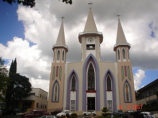
São Joaquim is a municipality in the state of Santa Catarina, situated in southern Brazil. It is located at latitude 28° 17' 38" south and longitude 49° 55' 54" west, with an altitude of 1,360 meters (4,460 ft). Its population in 2020 was 27,139 inhabitants. Located in the Planalto Serrano, it lies 136 km from Tubarão, 81 km from Lages and 227 km from Florianópolis. The town is home to a variety of ethnic groups, including Italian, Portuguese, Japanese and Afro- Brazilians, though composed mainly of descendants of German and Swedish immigrants. There is also a large proportation of the population from other states in Brazil, especially from Rio Grande do Sul.

Ivaí is a municipality in the state of Paraná in the Southern Region of Brazil.
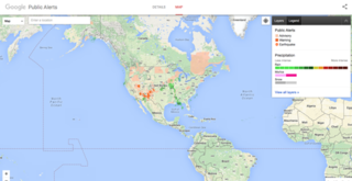
Google Public Alerts was an online notification service owned by Google.org that sends safety alerts to the United States, Australia, Canada, Colombia, Japan, Taiwan, Indonesia, Mexico, and Brazil launched on October 30, 2012. And to the Philippines on November 12, 2014. It is part of the Google Crisis Response team and publishes content from its partners of each country. If you activate Google Now, you can see suitable weather and public safety on Google Search and Google Maps.
The Servicio Meteorológico Nacional (SMN) is Argentina's national weather service under the Ministry of Defense that is tasked with observing, understanding, and predicting the weather and climate in Argentina and its surrounding waters. It provides weather forecasts, radar images, ozone, temperature and rainfall graphs, and satellite images. The purpose of these tasks is to contribute to protection of its inhabitants, sustainable economic development and to provide representation of Argentina to international meteorological organizations. Founded on 4 October 1872 by Federal law Nº559 during the presidency of Domingo Faustino Sarmiento, the organisation was the first meteorological organisation in South America and the third one in the world, after Hungary and the United States which were created in 1870 and 1871 respectively. It became a member of the World Meteorological Organization on 2 January 1951. Throughout its history, the organisation was dependent under different government ministries until in 2007 when it is currently under the Ministry of Defense.
References
- ↑ "Brazil | World Meteorological Organization". community.wmo.int. Retrieved 2021-04-28.
- ↑ "Instituto Nacional de Meteorologia - INMET". portal.inmet.gov.br. Retrieved 2021-04-28.
- ↑ "Portal da Câmara dos Deputados". www2.camara.leg.br. Retrieved 2021-04-28.