
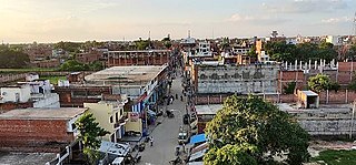
Ghazipur district is a district of Uttar Pradesh state in northern India. The city of Ghazipur is the district headquarters. The district is part of Varanasi Division. The region of Ghazipur is famous mainly for the production of its unique rose-scented Spray called Gulab Jal, and for the tomb of the Governor General of British India, Lord Cornwallis, who died here. His tomb is situated in Western part of City, and is conserved by Archaeological Survey of India.
Zamania is a town in the Indian state of Uttar Pradesh. Its municipal council is subordinate to the Ghazipur District. It is also the administrative head of Zamania tehsil,. It is also a very historical town, it derives its name from Ali Quli Khan Zaman, who was also known as Khan Zaman or Zaman Khan, he was a governor of Jaunpur, and Ghazipur during the time of Akbar.
The Great Sherpur is a region or a pargana of 'Shankarwar Vansh' in the Mohammadabad tehsil of Ghazipur district in Uttar Pradesh. It consists of Sherpur Kalan, Sherpur Khurd, Semra, Firozpur, villages which were established by the descendants of Dullah Rai. It has population of 31322 as per 2011 Census.
Reotipur is a historic village located in the Ghazipur district of Uttar Pradesh, India. Situated approximately 18 km from the district headquarters, Reotipur is known for its rich cultural heritage and traditional rural charm.
Dildarnagar Kamsar is a pargana (region) and a mashra comprising 34 settlements located around the Karamnasa River in the Ghazipur district of Uttar Pradesh and the Kaimur district of Bihar, India. Of these, 18 mouzas are the primary settlements. It is a prominent settlement of Khanzadas, also known as Kamsari Pathans, as well as Afghan Pathans, primarily of the Niazi and Yusufzai clans. The original name of the region was Kamsar, but due to close and historical ties with the family of Bara Pathans, the region is often referred to as Kamsar-O-Bar. It was established in 1542 by Raja Narhar Khan.
Usia is a village in Kamsaar, Uttar Pradesh, India. It is located southeast of Ghazipur and east of Dildarnagar, near the Bihar State border. The village has a population of 24,786 residents living in 3,471 households. Usia is approximately 7 km from Dildarnagar. Around 8500 Kamsar Pathans lived here as of 2011.
Rakasaha is a village in Kamsaar in the Indian state of Uttar Pradesh. Almost 6500 Kamsaar Pathans(NAWABS) lived in the village as of 2011.

Kurrah or Tajpur Kurrah is a village in Dildarnagar Kamsar region of Zamania tehsil in Ghazipur district. It is avillage of pathan Kamsaari pathans in the Indian state of Uttar Pradesh. Almost 3900 Kamsaar Pathans lived in the village as of 2011.

Gorasara is a village located in Dildarnagar Kamsar, Uttar Pradesh, India. Goarasara village was established by Bhikham Khan, son of Fateh Bahadur Khan, and great great grand son of Narhar Khan.

Saraila is a village in Kamsaar in the Indian state of Uttar Pradesh.Saraila is a village in Seorai Tehsil in Ghazipur District of Uttar Pradesh, India. It belongs to Varanasi Division. It is located 30 km to the south of District headquarters Ghazipur. 11 km from Seorai. 372 km from State capital Lucknow. The village was also a part of Daudpur Estate which had its capital at Dewaitha during Mughal and early British era.
Mania is a village in Kamsaar in the Indian state of Uttar Pradesh. It is located in Seorai Tehsil in the Ghazipur district. It is situated 22 km (14 mi) from the sub-district headquarters Seorai and from the district headquarters Ghazipur. Its total area is 428.68 hectares and a total population of 5736. Mania village was established in the early 1590 a.d. by Khizir Khan, who was a grandson of Narhar Khan.

Jaburna is a village in Kamsaar in the Indian state of Uttar Pradesh.
Fufuao or Rampur Phuphuaon is a village in Dildarnagar Kamsar in the Indian state of Uttar Pradesh.
Chainpuris a Town and corresponding community development block in Kaimur district of Bihar, India. It is located 11km west of Bhabua, the district headquarters of kaimur district .As of 2011, the village population was 11,306, in 1,653 households. The block population was 187,692, in 30,189 households. The main village Chainpur was also before known as Malikpur on the name of zamindar Malik Khan. Chainpur was established in early 1600s.
Mahārāja Kam Dév Singh Urf Rao Dalpat Karam Singh (1438–1532) was a Sikarwar Bhumeehar, king of the Kanyakubja Gotra and belonged to Sikri dynasty, which ruled over the region of Fatehpur Sikri and then Fatuhabad near Fatehpur. He was ruler of the Pahargarh Estate, which mainly comprised what are now the cities of Morena, Gwalior, Jhansi, and Shivpuri, in old Rajputana region. Kam Dev was the son of Maharaja Jay Raj Dev Singh who was the ruler of the Vijaypur Sikri state. With this Kam Dev and Dham Dev were an ally of Rana Sanga.
Seorai is a village of Dildarnagar Kamsar, and also serve as the headquarters of SeoraiTahsil in region of Ghazipur District of Uttar Pradesh, India. The Seorai tehsil was made a tehsil of the Ghazipur District in year 2016. It consists of 142 villages and one town. Seorai main village has a total area of 878.02 hectares and a population of 20000 but its total area is 1,082.83 hectares and a population of 20,530 which also includes Bhadaura. Seorai tehsil has the total area of 366.62 km2 (141.55 sq mi). Seorai also served as the capital of Kamsaar estate from late 1500s to mid 1600s.
Mednipur is the largest village by area in Zamania tehsil of Ghazipur District, Uttar Pradesh, India. There are two more villages along, one Kalupr and second Tari or Tarighat. All three are separate panchayats.
Jalalabad is a large village in Jakhania tehsil located in Ghazipur District of Uttar Pradesh India.

Zamania Canal is one of the largest canals located in Ghazipur District. The idea for the canal was given in 1910 and the plan was passed in 1911, but the canal was established in year 1912 for the better irrigation of Zamania tehsil. It starts from Chakkah Bandh and ends on the banks of Karmanasa River near Bara Village of Seorai Teshsil. It irrigates about 61,863 acres of land in Zamania tehsil. Its average width is 110 ft.
Dewaitha is a village of Dildarnagar Kamsar,in Zamania tehsil of Ghazipur, India, located on the banks of the Karmanasa River and it's tributary Eknaiya, The village had a population of 7,104 as of the 2011 Census of India. The place is inhabited by Kamsar Pathans..