
Vypin is one of the group of islands that form part of the city of Kochi (Cochin), in the Indian state of Kerala. Vypin forms a barrier island which lies between the Arabian Sea in the west and the Cochin backwaters formed by the various distributaries of Periyar river, in the east. The northernmost end of the island lies on the estuary of the Periyar river in Muziris (Kodungallur), and the southernmost end in the mouth of the Cochin Backwaters in Kalamukku near Fort Vypin.
Nileshwaram or Nileshwar or Neeleswaram is a municipality and a major town in Kasaragod District, state of Kerala, India. It is one of the three municipalities in Kasaragod district; the others are Kasaragod and Kanhangad. Nileshwaram is located on the estuary of Kavvayi Backwaters and Neeleshwaram River. Nileshwaram is referred to as the cultural capital of Kasaragod, the northernmost district of Kerala. "The first Chief Minister of Kerala and communist leader E. M. S. Namboodiripad,Kamaran Nair had contested elections to the Assembly from the Neeleswaram segment."

Peravoor is a town and Grama Panchayat in Kannur district of Kerala state in India. It is located 50 km (31 mi) east of Kannur and 40 km (25 mi) north east of Thalassery. And Iritty, the nearest municipality is 14 km (8.7 mi) north of Peravoor. Peravoor is situated in the Western Ghats mountain range.
Kakkanad is a region in the Kochi metropolitan area, located 7 km (4.3 mi) east of the Kochi city centre. The term is used to refer to an area covering Thrikkakara municipality and the built-up areas in the western parts of the adjoining Kunnathunad grama panchayat.

Varandarappilly is a panchayat near Puthukkad town in Thrissur district, Kerala, India. It is located 22 km from Thrissur City and 65 km from Kochi city. The Panchayath area is 102 km² and it has a population 27,343. Nandipulam, Mupliyam, Velupadam, Palappilly, and Kallayi are nearby villages. Alagappa Nagar, Mattathur and Puthukkad are the neighbouring Panchayaths. It is the hometown for Chemmannur group in the field of gold jewellery manufacturing.
Kuttippuram is a town and a block headquarters, which is situated in the Tirur Taluk, Malappuram district in the Indian state of Kerala. The town is located 32 kilometres south of Malappuram And 8 kilometers from valanchery. The Bharathappuzha river flows through Kuttippuram. According to the last Census of India conducted in 2011,
Pangode is an Indian village and a Grama Panchayat located in the Trivandrum district in the state of Kerala. The village is known for its participation in the Indian Independence Movement, through the Kallara-Pangode Struggle. It is situated in the foothills of Western Ghats.
Mulakulam is a village spread over the Kottayam and Ernakulam districts of Kerala, India, and is situated on the banks of the River Muvattupuzha. Mulakulam lies in one municipality viz Piravom municipality and Mulakulam grama panchayath. While Mulakulam North falls under the purview of Piravom municipality in Ernakulam District, Mulakulam South is governed by the Mulakulam panchayat of Kottayam district. The village is located about 38 kilometers from both Kottayam town and Kochi city. Piravom and Elanji is the nearest town. The population of this village is about 22360 people.
Alakode is an emerging town and a panchayat in Kannur district in the Indian state of Kerala. It is located 46 km (29 mi) north of district headquarters Kannur. Alakode is located on Taliparamba-Manakadavu-Coorg Road. Alakode was one of the major centers of Malabar Migration.

Kurumathur is a census town in Taliparamba taluk of Kannur district in Kerala state, India. Kurumathur is located 8 km (5.0 mi) east of Taliparamba town in SH 36.

Karadka is a village, block panchayat and grama panchayat in Kasaragod district in the state of Kerala, India.
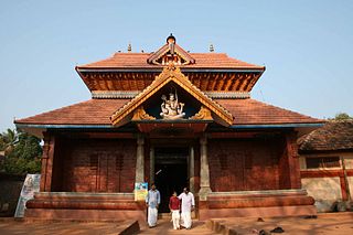
Annakara is a village in Thrissur district in the state of Kerala, India. Located on the western bank of Kechery river, it was earlier a border village, located near the junction of Malabar region of Madras presidency and Kochi kingdom. Annakara village comes under Mullassery Grama Panchayat. Chirakkal Bagavathy temple is located in this village.
A Techno-lodge is a small Information Technology park established by Government of Kerala in a small town or a village in Kerala. Techno-lodges constitute the third tier of the IT infrastructure in Kerala after the three hubs at Thiruvananthapuram (Technopark), Kochi (InfoPark) and Kozhikode (Cyberpark) and the secondary spokes in other major cities and towns. The Government has approved the setting up of two such parks in Kadakkal and Perinad Grama Panchayats in Kollam District.
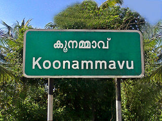
Koonammavu is a northern suburb of Kochi city which is associated in the Kochi metropolitan area. Koonammavu (Valluvally) is a census town in Kottuvally Panchayat, North Paravur Taluk, Ernakulam District, Kerala, India and lies between Edappally and North Paravur adjacent to Varappuzha.
Parali Grama panchayat is a gram panchayat in the Palakkad district, state of Kerala, India. It is a local government organization that serves the villages of Parli-I and Parli-II.
Anil Akkara is an Indian politician of the Indian National Congress, social worker and farmer from Kerala, India. He represented the Wadakkancherry constituency in Kerala Legislative Assembly.
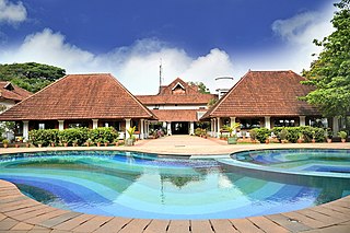
Mulavukad Grama Panchayat is grama panchayat in Ernakulam district, Kerala, India. It is situated in Vypin block panchayat. The major portion of this panchayat is an island with same name. It is situated some kilometres from Vypin island. The boundaries of the Mulvukad Panchayath are Kadamakkudy, Njarakkal Panchayaths in the North, Kochi Corporation in the East and South and Elangunnappuzha Panchayath in the West. This island is situated very near to Kochi city. Bolgatty Palace is a popular tourist attraction in the southern part of the island. This palace was built by Dutch in 1774. Now it is under the control of Department of Tourism, Government of Kerala.
Elections to local bodies in Kerala were held in December 2020. Polling took place over 3 days; on 8, 10 and 14 December, with the votes counted and results announced on 16 December.

Mangalam is a coastal village in Tirur Taluk, Malappuram district, Kerala, India. The village is located 9 kilometres (5.6 mi) south-west to the town of Tirur, 16 kilometres (9.9 mi) away from Ponnani, and 17 kilometres (11 mi) south to Tanur. Kootayi, known for its picturesque beach, is an important town in the jurisdiction of Mangalam Grama Panchayat.

