Normandy, Illinois | |
|---|---|
 Normandy, Illinois  Normandy, Illinois | |
| Coordinates: 41°33′43″N89°38′57″W / 41.56194°N 89.64917°W | |
| Country | United States |
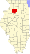
| State | Illinois |
| County | Bureau |
| Elevation | 653 ft (199 m) |
| Time zone | UTC-6 (Central (CST)) |
| • Summer (DST) | UTC-5 (CDT) |
| Area codes | 815 & 779 |
| GNIS feature ID | 414550 [1] |
Normandy is an unincorporated community in Bureau County, Illinois, United States, located on Illinois Route 92, west of Walnut.