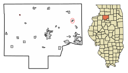
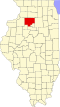
New Bedford, Illinois

Last updated

New Bedford
Bureau County Illinois Incorporated and Unincorporated areas New Bedford Highlighted.svg
Location of New Bedford in Bureau County, Illinois.
Illinois in United States (US48).svg
Location of Illinois in the United States
Coordinates: 41°30′47″N89°43′09″W / 41.51306°N 89.71917°W / 41.51306; -89.71917
CountryUnited States
StateIllinois
County Bureau
Township Greenville
Area
[1]
  Total0.155 sq mi (0.40 km2)
  Land0.155 sq mi (0.40 km2)
  Water0.00 sq mi (0.0 km2)  0%
Population
 (2020)
  Total76
  Density490/sq mi (190/km2)
Time zone UTC-6 (CST)
  Summer (DST) UTC-5 (CDT)
ZIP Code(s)
61346
Area codes 815 & 779
FIPS code 17-52155
Wikimedia CommonsNew Bedford, Illinois

New Bedford is a village in Bureau County, Illinois, United States. The population was 76 at the 2020 census. It is part of the Ottawa Micropolitan Statistical Area.

Contents

History

In October 1836, Henry Thomas of West Bureau Township registered land at the narrows (now New Bedford) and for a number of years it was the only registered tract in that section of the county. In the spring of 1837, Cyrus Watson, the first settler on Green river, built a cabin on Thomas' land, believing it to be vacant. About this time a state road was laid from Princeton to Prophetstown on the Rock River, crossing the Green River at this point. Henry Thomas built a ferry boat, and for a number of years it was known as Thomas' Ferry. [2]

Pic.1: Looking Northward from West side of Main Street.
Pic.2: Looking Northward from East side of Main Street.
Pic.3: Looking Northward across the Green River bridge. This section of the river is now called the Old Channel.
Pic.4: Looking Southward across the Green River bridge. Large house on right belonged to the Bollman family.
Pic.5: Spratt Department store on East side of Main street. The cement step still remains, located across the street from the Post Office.
Pic.6: F. Janderson Department store on West side of Main street.

Geography

New Bedford is located at 41°30′47″N89°43′09″W / 41.51306°N 89.71917°W / 41.51306; -89.71917 . [3]

According to the 2021 census gazetteer files, New Bedford has a total area of 0.16 square miles (0.41 km2), all land. [1]

Demographics

Historical population
CensusPop.Note
1880 55
1960 166
1970 152−8.4%
1980 1520.0%
1990 65−57.2%
2000 9546.2%
2010 75−21.1%
2020 761.3%
U.S. Decennial Census [4]

As of the 2020 census [5] there were 76 people, 32 households, and 18 families residing in the village. The population density was 490.32 inhabitants per square mile (189.31/km2). There were 39 housing units at an average density of 251.61 per square mile (97.15/km2). The racial makeup of the village was 94.74% White and 5.26% from two or more races. Hispanic or Latino of any race were 2.63% of the population.

There were 32 households, out of which 12.5% had children under the age of 18 living with them, 37.50% were married couples living together, 9.38% had a female householder with no husband present, and 43.75% were non-families. 40.63% of all households were made up of individuals, and 25.00% had someone living alone who was 65 years of age or older. The average household size was 2.22 and the average family size was 1.78.

The village's age distribution consisted of 8.8% under the age of 18, 14.0% from 18 to 24, 15.8% from 25 to 44, 15.8% from 45 to 64, and 45.6% who were 65 years of age or older. The median age was 59.5 years. For every 100 females, there were 111.1 males. For every 100 females age 18 and over, there were 92.6 males.

The median income for a household in the village was $47,500, and the median income for a family was $57,500. Males had a median income of $20,000 versus $41,250 for females. The per capita income for the village was $23,430. About 22.2% of families and 26.3% of the population were below the poverty line, including 80.0% of those under age 18 and 26.9% of those age 65 or over.

Related Research Articles

<span class="mw-page-title-main">Bridgeville, Delaware</span> Town in Delaware, United States

Bridgeville is a town in Sussex County, Delaware, United States. According to the 2010 census, the population is 2,048, an increase of 42.6% from the previous decade. It is part of the Salisbury, Maryland-Delaware Metropolitan Statistical Area.

<span class="mw-page-title-main">Bedford Park, Illinois</span> Village in Illinois, United States

Bedford Park is a village in Cook County, Illinois, United States, and is an industrial suburb of Chicago. The population was 602 at the 2020 census. Bedford Park consists of a small residential area and vast amounts of heavy industry sprawling to the east and a small amount to the west.

<span class="mw-page-title-main">East Dundee, Illinois</span> Village in Illinois, United States

East Dundee is a village in Kane County with a small section in Cook County. The population was 3,152 at the 2020 census.

<span class="mw-page-title-main">Lee, Illinois</span> Village in Illinois, United States

Lee is a village in DeKalb County and Lee County, Illinois, United States. The population was 313 at the 2020 census.

<span class="mw-page-title-main">Reynolds, Illinois</span> Village in Illinois, United States

Reynolds is a village mainly in Rock Island County in the U.S. state of Illinois. The population was 498 at the 2020 census. A small portion on the south side is in Mercer County. The village was founded in 1876.

<span class="mw-page-title-main">Exeter, Illinois</span> Village in Illinois, United States

Exeter is a village in Scott County, Illinois, United States. The population was 70 at the 2000 census. It is part of the Jacksonville Micropolitan Statistical Area.

<span class="mw-page-title-main">Millers Falls, Massachusetts</span> Census-designated place in Massachusetts, United States

Millers Falls is a census-designated place (CDP) in the towns of Montague and Erving in Franklin County, Massachusetts, United States. The population was 1,139 at the 2010 census. It is part of the Springfield, Massachusetts metropolitan statistical area.

<span class="mw-page-title-main">Shelburne Falls, Massachusetts</span> Census-designated place in Massachusetts, United States

Shelburne Falls is a historic village in the towns of Shelburne and Buckland in Franklin County, Massachusetts, United States. The village is a census-designated place (CDP) with a population of 1,731 at the 2010 census. It is part of the Springfield, Massachusetts, Metropolitan Statistical Area.

<span class="mw-page-title-main">Gilsum, New Hampshire</span> Town in New Hampshire, United States

Gilsum is a town in Cheshire County, New Hampshire, United States. The population was 752 at the 2020 census. Home to Bear's Den Natural Area, Gilsum includes Gilsum Lower Village.

<span class="mw-page-title-main">Bath, New Hampshire</span> Town in New Hampshire, United States

Bath is a town in Grafton County, New Hampshire, United States. The population was 1,077 at the 2020 census, unchanged from the 2010 census. Now a tourist destination and commuter town for Littleton, the town is noted for its historic architecture, including the Brick Store and three covered bridges. Bath includes the village of Swiftwater and part of the district known as Mountain Lakes.

<span class="mw-page-title-main">Campton, New Hampshire</span> Town in New Hampshire, United States

Campton is a town in Grafton County, New Hampshire, United States. The population was 3,343 at the 2020 census. Campton, which includes the villages of Blair, Campton Hollow, Lower Campton and West Campton, is home to Blair State Forest and Livermore Falls State Forest. It is located in the foothills of the White Mountains, and parts of the White Mountain National Forest are in the northeast and northwest.

<span class="mw-page-title-main">Natural Bridge, New York</span> Census-designated place in New York, United States

Natural Bridge is a hamlet and census-designated place (CDP) in Jefferson County, New York, United States. As of the 2010 census it had a population of 365.

<span class="mw-page-title-main">Everett, Pennsylvania</span> Borough in Pennsylvania, United States

Everett is a borough in Bedford County, Pennsylvania, United States. The population was 1,775 at the 2020 census.

<span class="mw-page-title-main">Sheldon, Rusk County, Wisconsin</span> Village in Wisconsin, United States

Sheldon is a village in Rusk County, Wisconsin, United States. The population was 237 at the 2010 census.

<span class="mw-page-title-main">North Augusta, South Carolina</span> City in South Carolina, United States

North Augusta is a city in Aiken and Edgefield counties in the U.S. state of South Carolina, on the north bank of the Savannah River. It lies directly across the river, and state border, from Augusta, Georgia. The population was 24,379 at the 2020 census. The city is included in the Central Savannah River Area (CSRA) and is part of the Augusta, Georgia, metropolitan area.

<span class="mw-page-title-main">Somerset, Massachusetts</span> Town in Massachusetts, United States

Somerset is a town in Bristol County, Massachusetts, United States. The population was 18,303 at the 2020 census. It is the birthplace and hometown of Clifford Milburn Holland (1883–1924), the chief engineer and namesake of the Holland Tunnel in New York City.

<span class="mw-page-title-main">Warwick (village), New York</span> Village in New York, United States

Warwick is a village in Orange County, New York, United States, in the southeastern section of the town of Warwick. The village's population was 6,652 at the time of the 2020 census. It is part of the New York–Newark–Bridgeport, NY-NJ-CT-PA Combined Statistical Area.

<span class="mw-page-title-main">Newfane (village), Vermont</span> Village in Vermont, United States

Newfane is an incorporated village in the town of Newfane in Windham County, Vermont, United States. The population was 87 at the 2020 census.

<span class="mw-page-title-main">Woodstock (village), Vermont</span> Village in Vermont, United States

Woodstock is an incorporated village located within the town of Woodstock in Windsor County, Vermont, United States. As of the 2020 census, the village population was 900.

<span class="mw-page-title-main">Winneconne, Wisconsin</span> Village in Wisconsin, United States

Winneconne is a village in Winnebago County, Wisconsin. The population was 2,383 at the time of the 2010 census. The village is located within the Town of Winneconne. Developed along the Wolf River, the city is in the middle of the Wolf Chain of lakes, including Poygan, Winneconne, and Butte des Morts. It is host to numerous bass fishing tournaments.

References

  1. 1 2 Bureau, US Census. "Gazetteer Files". Census.gov. Retrieved June 29, 2022.
  2. Reminiscences of Bureau County by Nehemiah Matson, Princeton, Ill.: Republican Book and Job Office, 1872. p. 383. Retrieved 8 August 2010.
  3. "US Gazetteer files: 2010, 2000, and 1990". United States Census Bureau. February 12, 2011. Retrieved April 23, 2011.
  4. "Census of Population and Housing". Census.gov. Retrieved June 4, 2015.
  5. "Explore Census Data". data.census.gov. Retrieved June 28, 2022.