Bureau Junction, Illinois Bureau | |
|---|---|
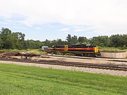 An Iowa Interstate train at the railroad junction. | |
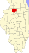
 Location of Bureau Junction in Bureau County, Illinois. | |
| Coordinates: 41°17′21″N89°22′4″W / 41.28917°N 89.36778°W [1] | |
| Country | USA |
| State | Illinois |
| County | Bureau |
| Township | Leepertown |
| Incorporated as a town | 1874 |
| Government | |
| • Village president | Thomas Hollingsworth [2] |
| Area | |
• Total | 1.51 sq mi (3.9 km2) |
| • Land | 1.45 sq mi (3.8 km2) |
| • Water | 0.07 sq mi (0.18 km2) |
| Elevation | 528 ft (161 m) |
| Population (2020) | |
• Total | 281 |
| 278 | |
| • Density | 194/sq mi (74.8/km2) |
| Time zone | UTC-6 (CST) |
| • Summer (DST) | UTC-5 (CDT) |
| ZIP codes | 61315, 61356 |
| Area code | 815 |
| FIPS code | 17-09681 |
| GNIS feature ID | 2397497 [1] |
Bureau Junction, usually called Bureau, is a village in Bureau County, Illinois, United States. The population was 281 at the 2020 census. The village name is shown as both "Bureau Junction" [5] and "Bureau" on federal maps, [6] and is commonly called "Bureau", including by phone companies [7] and the United States Post Office. [8] It is part of the Ottawa Micropolitan Statistical Area. Bureau Junction was the point where the Rock Island Line railroad's branch line to Peoria split. Track west and south of Bureau is operated by Iowa Interstate, while tracks east to Chicago were formerly operated by CSX but are currently leased to Iowa Interstate.