
The Boston Post Road was a system of mail-delivery routes between New York City and Boston, Massachusetts, that evolved into one of the first major highways in the United States.

Attleboro is a city in Bristol County, Massachusetts, United States. It was once known as "The Jewelry Capital of the World" for its many jewelry manufacturers. According to the 2020 census, Attleboro had a population of 46,461.

North Attleborough, alternatively spelled North Attleboro, is a city in Bristol County, Massachusetts, United States. The population was 30,834 at the 2020 United States Census.

The La Grange Historic District is a national historic district located in La Grange, North Carolina, United States. The district, originally encompassing 225 buildings and 1 structure, includes the historic commercial, residential, and industrial center of La Grange. The buildings include notable examples of Gothic Revival, Queen Anne and Bungalow/American Craftsman styles of architecture and date between the 1850s and the 1940s. Located in the district is the separately listed La Grange Presbyterian Church. Other notable buildings include the Sutton-Kinsey House, Walter Pace House, Sutton-Fields House, Colonel A. C. Davis House (1887), and the Rouse Banking Company Building (1908). The historic district was added to the National Register of Historic Places in May 2000.

The Amherst Central Business District is a historic district encompassing the heart of downtown Amherst, Massachusetts. Centered on the northern section of the long town common, the area has been the civic and commercial heart of the town since the 18th century. The district was listed on the National Register of Historic Places in 1991, and slightly enlarged in 2011.
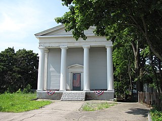
The East Attleborough Academy is an historic former school building at 28 Sanford Street in Attleboro, Massachusetts. Built in 1843, it is the town's only example of a Greek Revival temple front building. It originally served as a private academy, and has since served as the town's first high school, and as an office building. It is now home to the town's historical society. The building was listed on the National Register of Historic Places in 1985.

The First Parsonage for Second East Parish Church was an historic church parsonage at 41 S. Main Street in Attleboro, Massachusetts. Built in 1822, it was a good local example of Federal period architecture. At the time of its listing on the National Register of Historic Places in 1980, it was the oldest documented building in the town center. It was demolished in 1998.

The South Washington Street Historic District is a historic district encompassing 200 years of residential architecture in North Attleborough, Massachusetts. It extends along South Washington Street in the central portion of the town, between Elm Street in the north, and Sutherland Street in the south and includes two properties on Hunking Street. The district was added to the National Register of Historic Places in 1995.
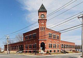
The H.F. Barrows Manufacturing Company Building, now the North Attleborough Police Station, is a historic industrial building in North Attleborough, Massachusetts. The elegant brick building was built in 1905–06, and was home for many years to one of the town's most successful jewelry businesses. It was listed on the National Register of Historic Places in 2001. Today the building serves as the headquarters for the North Attleborough Police Department.

The Old Town Historic District is a historic district in North Attleborough, Massachusetts, which encompasses the historic early town center of Attleboro, which it was originally a part of. It was here that Attleboro's first church was built, and its militia training ground was laid out. The district retains 18th-century vestiges of this early history, and was largely bypassed by 19th-century industrialization. The district was added to the National Register of Historic Places in 1991.

The D. E. Makepeace Company is a historic industrial building at 46 Pine Street in Attleboro, Massachusetts. Built in 1899-1900, it is one of the city's best examples of a jewelry factory building of the period. The Makepeace Company was a major contributor to the city's reputation at the turn of the 20th century as America's jewelry capital. The building, now converted to residences, was listed on the National Register of Historic Places in 1985.

The Attleborough Falls Historic District is a predominantly residential historic district on Mt. Hope and Towne Streets in North Attleborough, Massachusetts. Located just south of the Ten Mile River, it encompasses a stylish mid-to-late 19th century residential area that developed in a previously rural area due to industrial development across the river. The district was added to the National Register of Historic Places in 2004.

The Harvard Center Historic District is a historic district encompassing the traditional village center of Harvard, Massachusetts, USA. The district is centered on the town common, a triangular grassy space bounded by Elm Street, Still River Road, and Ayer Road. The common is ringed by residences, civic and religious buildings, and a small commercial area. The common was laid out when the town was founded in 1732, and has grown, mainly in periods of growth at the late 18th and late 19th/early 20th centuries. Most of the village's buildings post-date 1831. The district was added to the National Register of Historic Places in 1997.

The Commonwealth Avenue Historic District is a historic district on Commonwealth Avenue on the north side from Stanley Street to beyond Robinson Street in North Attleborough, Massachusetts. The area encompasses a variety of stylish 19th-century houses, as well as two 19th-century industrial buildings, depicting the proximity of wealthy industrial owners and managers to their factories. The district was added to the National Register of Historic Places in 2003.

The University–Cultural Center MRA is a pair of multiple property submissions to the National Register of Historic Places which were approved on April 29 and May 1, 1986. The structures included are all located in Midtown, near Woodward Avenue and Wayne State University in Detroit, Michigan. The two submissions are designated the University–Cultural Center MRA Phase I, containing five properties, and the University–Cultural Center MRA Phase II, containing three properties.

There are nine historic districts in Meridian, Mississippi. Each of these districts is listed on the National Register of Historic Places. One district, Meridian Downtown Historic District, is a combination of two older districts, Meridian Urban Center Historic District and Union Station Historic District. Many architectural styles are present in the districts, most from the late 19th century and early 20th century, including Queen Anne, Colonial Revival, Italianate, Art Deco, Late Victorian, and Bungalow.

The Greenwich Avenue Historic District is a historic district representing the commercial and civic historical development of the downtown area of the town of Greenwich, Connecticut. The district was listed on the National Register of Historic Places on August 31, 1989. Included in the district is the Greenwich Municipal Center Historic District, which was listed on the National Register the year before for the classical revival style municipal buildings in the core of Downtown. Most of the commercial buildings in the district fall into three broad styles, reflecting the period in which they were built: Italianate, Georgian Revival, and Commercial style. The district is linear and runs north–south along the entire length of Greenwich Avenue, the main thoroughfare of Downtown Greenwich, between U.S. Route 1 and the New Haven Line railroad tracks.

The Town Center Historic District encompasses the historic village center of South Hampton, New Hampshire. Centered around the Barnard Green, the town common, on New Hampshire Route 107A, it includes architectural reminders of the town's growth and change over time. The district was listed on the National Register of Historic Places in 1983.

The Muskegon Historic District is a public and residential historic district in Muskegon, Michigan, consisting of the four blocks between Clay Avenue, Webster Avenue, Second Street, and Sixth Street, and the two blocks between Webster Avenue, Muskegon Avenue, Second Street and Fourth Street. The district was placed on the National Register of Historic Places in 1972.

The Center Avenue Neighborhood Residential District is a residential historic district located in Bay City, Michigan, running primarily along Center, Fifth, and Sixth Avenues between Monroe and Green Avenues, with additional portions of the district along Fourth between Madison and Johnson, down to Tenth Avenue between Madison and Lincoln, along Green to Ridge, and around Carroll Park. The original section, along Center and portions of Fifth and Sixth, was listed on the National Register of Historic Places in 1982. A boundary increase including the other sections of the neighborhood was listed in 2012.


