The Ashburnham Center Historic District is a historic district encompassing the core of the village center of Ashburnham, Massachusetts in the United States. It is a well-preserved industrial village that experienced its most significant period of growth in the mid-19th century. The district was added to the National Register of Historic Places in 1999.

The Pine Grove Cemetery, also known as the First Meetinghouse Burying Ground, is an historic cemetery on Tremaine and Main Streets in Leominster, Massachusetts. Established in 1742, it is the city's oldest cemetery, and the principal surviving element of the town's early settlement. It was originally located adjacent to the community's first meeting house, built in 1741 and dismantled in 1774. The cemetery, closed to burials since 1937, was listed on the National Register of Historic Places on March 12, 2008.

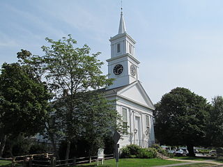
The Mendon Center Historic District is a historic district encompassing the village center of Mendon, Massachusetts, and some of its surrounding rural areas. It is roughly bounded by Main, Hastings, Maple, North, Washington & George Streets. The village is centered on the triangle defined by Main, Hastings, and Maple Streets, with dwellings built up on the roads that radiate away from this area. Founders' Park, located at the junction of Main, Hastings, North and Milford Streets, is the site of the original town center, where the first meeting house was located. The district has residential buildings dating from the 18th to the mid-20th centuries, in a wide variety of styles. The focal point of the town center is the Second Unitarian Church, an 1820 building designed by Worcester architect Elias Carter.

The Lunenburg Historic District is a historic district encompassing the historic center of Lunenburg, Massachusetts. The district is centered on a stretch of Main Street which connects two triangular intersections. It includes many of the town's oldest buildings, including the c. 1724 Cushing House, and the c. 1730 Stillman Stone House. Three of the town's most significant institutional buildings were built before 1850: the town hall, the Congregational church, and the Methodist church. The district was added to the National Register of Historic Places in 1988.

Westminster Village–Academy Hill Historic District encompasses the historic first town center of Westminster, Massachusetts, as well as its later early-19th century commercial core. Centered at the junction Main and South Streets with Academy Hill Road, it contains fine examples of Colonial, Federal, and Greek Revival architecture, including the 1839 town hall. The district was listed on the National Register of Historic Places in 1983.

The Center Village District encompasses the historic village center of Lancaster, Massachusetts. Settled in 1643, it has few traces of its early history, but is now a well-kept rural town center with a predominantly residential and civic character. It includes the First Church of Christ, Lancaster, which is a U.S. National Historic Landmark, and was listed on the National Register of Historic Places in 1977.

The South Lancaster Engine House is a historic fire station at 283 South Main Street in South Lancaster, Massachusetts. Built in 1888, it is the town's oldest operating firestation, and a distinctive example of period Victorian architecture. The building was listed on the National Register of Historic Places in 1976. It presently houses engines 3 and 4 of the Lancaster Fire Department.

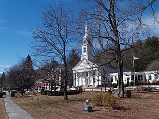
The Petersham Common Historic District encompasses the historic town center of Petersham, Massachusetts. Laid out in 1733 and centered on the town common bounded by Main and Common Streets, it retains most of its 19th-century character, with only a few turn-of-the-20th-century civic buildings adding later character. The district was added to the National Register of Historic Places in 1982.
The Sterling Center Historic District is a historic district encompassing the central village of Sterling, Massachusetts. The district is roughly bounded by Meetinghouse Hill and Main, Maple and Kendall Hill, Boulding, Worcester and Princeton Street. The town common, which is the focal point of the district, was laid out in 1724, when the area was still part of Lancaster. The area includes 18th- and 19th-century houses, as well as several church buildings, and the 1835 town hall.
The Centerville Historic District is a historic district encompassing the heart of the village of Centerville in Barnstable, Massachusetts. The district extends along Main Street from a point north of its junction with Old Stage Road and Park Avenue, south to the junction with Church Hill Road. Most of the buildings in the district were built in the middle decades of the 19th century, although its oldest building, the Austin Bearse House, was built c. 1690. The area's growth was spurred by the relocation in 1826 of the Congregational Church building to its present location. The district was listed on the National Register of Historic Places in 1987.

The Hatfield Center Historic District encompasses the traditional center of Hatfield, Massachusetts. The area, first laid out in 1661, is bounded by Maple Street to the south, the Connecticut River to the east, Day Avenue and School Street to the north, and the Mill River to the west. The area's layout and land use patterns are relatively little altered since they were laid out, leaving a well-preserved early colonial village landscape. The district was added to the National Register of Historic Places in 1994.

The Manchester Village Historic District encompasses the village center of the seaside town of Manchester-by-the-Sea, Massachusetts. It is stretched along Massachusetts Route 127, which runs in an arc around the northern part of Manchester Harbor, extending north on School and North Streets at the very center of the village. It is bounded on the western end roughly by Bennett Street and Ashland Avenue, and on the east by Beach Street. The village had its beginnings in the 17th century as a fishing and agrarian center, and its major roads were laid out by the late 18th century. The village was at its height in the first half of the 19th century as a fishing center, and it is from that time that most of its buildings date. Growth in the later 19th century was slower, as sea-related economic activity declined and cabinetmaking grew as a local industry.

The Graniteville Historic District of Westford, Massachusetts encompasses one of the town's historic 19th century industrial villages. The area was, until the arrival of the railroad in 1847, primarily known for its granite quarries. The railroad's arrival prompted the construction of an industrial mill by Charles G. Sargent, and the area developed rapidly thereafter. A significant amount of housing stock, as well as civic institutional buildings, were built during the second half of the 19th century. The district is bounded on the east by River Street and on the south by Bridge Street and North Main Street. The western edge of the district runs just before North Main Street's junction with West Street, northward and then eastward to encompass a number of quarry sites, before meeting North Main Street at River Street.

The Southbridge-Sargent Manufacturing District encompasses a collection of three 19th-century factory buildings near a historically important railroad junction in southern Worcester, Massachusetts. They were built near the intersection of Sargent and Gold Streets, just south of Southbridge Street. The location is close to a junction of three major railroads: the Boston and Albany, the Norwich and Worcester, and the New York, New Haven, and Hartford. The area was once a major industrial part of the city, but has lost many of its historic factory buildings in the 20th century.

The Boynton and The Windsor are a pair historic buildings at 718 and 720 Main Street in Worcester, Massachusetts. They are nearly identical brick apartment buildings that were constructed c. 1887 to designs by Barker & Nourse, and are well preserved instances of late 19th century apartment house construction that once lined Main Street for many blocks. Of the two the Boynton is the better preserved, with an unaltered exterior.

The Brightside Apartments is a historic apartment house at 2 King Street in Worcester, Massachusetts. Built in 1888 to a design by Fuller & Delano, it is one of southern Worcester's finest 19th century apartment blocks. The building was listed on the National Register of Historic Places in 1980, even though it had recently experienced some damage due to a minor fire.

The Elm Street Historic District encompasses a collection of high-style Queen Anne Victorian three-decker houses at 132-148 Elm Street in Worcester, Massachusetts. Normally a building style intended for occupation by the working classes of the city, these stylish buildings were built 1904–06 facing Elm Park on the fashionable west side, and attracted a higher class of occupant. The district was listed on the National Register of Historic Places in 1990.

The High–School Streets Historic District encompasses a cluster of fourteen houses representing one of the best well preserved mid-19th century residential districts in Southbridge, Massachusetts. Located in the city's Globe Village area, the houses are predominantly Greek Revival in style. The district was listed on the National Register of Historic Places in 1989.
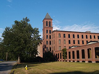
The Lancasters Mills are a 19th-century complex of predominantly brick mill buildings at the corner of Green and Chestnut Streets, near the center of Clinton, Massachusetts. Founded in 1844 by a group led by Erastus and Horatio Bigelow, the Lancaster Mills were the first major mill to produce gingham fabrics. Its success in the 1840s led to the establishment of the town of Clinton out of Lancaster. The 29-acre (12 ha) complex was expanded regularly throughout the 19th century and was used for textile manufacturing into the 20th century.

The Oxford Main Street Historic District is a national historic district encompassing the historic center of Oxford, Massachusetts. The 95-acre (38 ha) district extends along Main Street from Huguenot Street in the south to Front Street in the north. Its oldest buildings are residential houses built in the late 19th century, while most of the properties were built in the 19th century, with Greek Revival architecture predominating. The oldest commercial building, the John Wetherell Store, was built c. 1817, and now houses offices. The district includes four churches, including the 1793 Universalist church and 1829 First Congregational Church, and a number of municipal buildings, including the town hall, two schools, and the 1903 Classical Revival Charles Larned Memorial Library.