Northway Junction, Alaska

Last updated

Northway Junction, Alaska
CDP
Relief map of USA Alaska.png
Red pog.svg
Northway Junction
North America laea relief location map with borders.jpg
Red pog.svg
Northway Junction
World location map (equirectangular 180).svg
Red pog.svg
Northway Junction
Coordinates: 63°0′23″N141°46′41″W / 63.00639°N 141.77806°W / 63.00639; -141.77806
CountryUnited States
State Alaska
Census Area Southeast Fairbanks
Government
   State senator Click Bishop (R)
   State rep. Mike Cronk (R)
Area
  Total8.6 sq mi (22.2 km2)
  Land8.5 sq mi (21.9 km2)
  Water0.1 sq mi (0.3 km2)
Elevation
1,693 ft (516 m)
Population
 (2010)
  Total54
  Density6.3/sq mi (2.4/km2)
Time zone UTC-9 (Alaska (AKST))
  Summer (DST) UTC-8 (AKDT)
Area code 907
FIPS code 02-56250
GNIS feature ID1866965

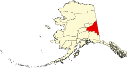
Northway Junction was a census-designated place (CDP) in Southeast Fairbanks Census Area, Alaska, United States. It was merged with Northway CDP prior to the 2020 Census. [1] The population was 54 at the 2010 census, down from 72 in 2000.

Contents

Geography

According to the United States Census Bureau, the CDP has a total area of 8.6 square miles (22 km2), of which, 8.5 square miles (22 km2) of it is land and 0.1 square miles (0.26 km2) of it (1.40%) is water.

Demographics

Historical population
CensusPop.Note
1990 88
2000 72−18.2%
2010 54−25.0%
U.S. Decennial Census [2]

Northway Junction first appeared on the 1990 U.S. Census as a census-designated place (CDP).

As of the census [3] of 2000, there were 72 people, 23 households, and 18 families residing in the CDP. The population density was 8.5 inhabitants per square mile (3.3/km2). There were 29 housing units at an average density of 3.4 per square mile (1.3/km2). The racial makeup of the CDP was 41.67% White, 48.61% Native American, and 9.72% from two or more races. 4.17% of the population were Hispanic or Latino of any race.

There were 23 households, out of which 47.8% had children under the age of 18 living with them, 56.5% were married couples living together, 8.7% had a female householder with no husband present, and 21.7% were non-families. 17.4% of all households were made up of individuals, and none had someone living alone who was 65 years of age or older. The average household size was 3.13 and the average family size was 3.44.

In the CDP, the age distribution of the population shows 38.9% under the age of 18, 6.9% from 18 to 24, 34.7% from 25 to 44, 19.4% from 45 to 64, . The median age was 27 years. For every 100 females, there were 84.6 males. For every 100 females age 18 and over, there were 131.6 males.

The median income for a household in the CDP was $67,500, and the median income for a family was $63,750. Males had a median income of $38,750 versus $36,250 for females. The per capita income for the CDP was $16,439. There were 11.1% of families and 15.8% of the population living below the poverty line, including 20.0% of under eighteens and none of those over 64.

Related Research Articles

<span class="mw-page-title-main">Tuluksak, Alaska</span> CDP in Alaska, United States

Tuluksak is a census-designated place (CDP) in Bethel Census Area, Alaska, United States. At the 2010 census the population was 373, down from 428 in 2000.

<span class="mw-page-title-main">Denali Park (CDP), Alaska</span> Census-designated place in Alaska, United States

Denali Park, formerly McKinley Park, is a census-designated place (CDP) in Denali Borough, in the U.S. state of Alaska. As of the 2020 census, the population of the CDP was 163, down from 185 at the 2010 census.

<span class="mw-page-title-main">Primrose, Alaska</span> Census-designated place in Alaska, United States

Primrose is a census-designated place (CDP) in Kenai Peninsula Borough, Alaska, United States. The population was 78 at the 2010 census, down from 93 at the 2000 census. Primrose is one of a number of small communities located north of Seward along the Seward Highway.

Womens Bay is a census-designated place (CDP) in Kodiak Island Borough, Alaska, United States. At the 2020 census the population was 743, up from 719 in 2010. The name is correctly spelled "Womens", without an apostrophe.

<span class="mw-page-title-main">Chignik Lake, Alaska</span> Census-designated place in Alaska, United States

Chignik Lake is a census-designated place (CDP) in Lake and Peninsula Borough, Alaska, United States. It is 475 miles (764 km) southwest of Anchorage. At the 2020 census, the population was 61.

<span class="mw-page-title-main">Chase, Alaska</span> CDP in Alaska, United States

Chase is a census-designated place (CDP) in Matanuska-Susitna Borough, Alaska, United States. Located 9.2 miles north from Talkeetna, it is part of the Anchorage, Alaska Metropolitan Statistical Area. The population was 19 at the 2020 census, down from 34 in 2010.

<span class="mw-page-title-main">Farm Loop, Alaska</span> CDP in Alaska, United States

Farm Loop is a census-designated place (CDP) in Matanuska-Susitna Borough, Alaska, United States. It is part of the Anchorage, Alaska Metropolitan Statistical Area. At the 2020 census the population was 2,747, up from 1,028 in 2010.

<span class="mw-page-title-main">Gateway, Alaska</span> CDP in Alaska, United States

Gateway is a census-designated place (CDP) in Matanuska-Susitna Borough, Alaska, United States. It is part of the Anchorage, Alaska Metropolitan Statistical Area. The population was 5,748 at the 2020 census, up from 5,552 in 2010. Gateway is the fifth-most populated CDP in the borough.

<span class="mw-page-title-main">Meadow Lakes, Alaska</span> CDP in Alaska, United States

Meadow Lakes is a census-designated place (CDP) in Matanuska-Susitna Borough, Alaska, United States. Located west of Wasilla, it is part of the Anchorage, Alaska Metropolitan Statistical Area. As of the 2020 census, the population was 9,197, up from 7,570 in 2010. It is the fifth-most populated CDP in Alaska and the third largest community in the borough.

<span class="mw-page-title-main">Sutton-Alpine, Alaska</span> Census-designated place in Alaska, United States

Sutton is a census-designated place (CDP) in the Matanuska-Susitna Borough in the U.S. state of Alaska. At the 2020 census the population was 1,038, down from 1,447 in 2010. The CDP includes the former coal mining community and road construction camp of Sutton, as well as the former mining camps of Eska and Jonesville.

<span class="mw-page-title-main">Whale Pass, Alaska</span> Second Class City in Alaska, United States

Whale Pass is a second class city in Prince of Wales-Hyder Census Area, Alaska, United States. The population was 31 at the 2010 census, down from 58 in 2000.

<span class="mw-page-title-main">Cube Cove, Alaska</span> Unincorporated community in the state of Alaska, United States

Cube Cove was an unincorporated community and census-designated place on the northwestern side of Admiralty Island in the Hoonah-Angoon Census Area of the U.S. state of Alaska. The population was 72 at the 2000 United States Census, but it was not included in the 2010 census.

<span class="mw-page-title-main">Klukwan, Alaska</span> Census-designated place in Alaska, United States

Klukwan is a census-designated place (CDP) in Alaska, United States. It is technically in Hoonah-Angoon Census Area, though it is an enclave of Haines Borough. At the 2010 census the population was 95, down from 139 at the 2000 census.

<span class="mw-page-title-main">Alcan Border, Alaska</span> Census-designated place in Alaska, United States

Alcan Border, also known as Port Alcan, is a census-designated place in the Southeast Fairbanks Census Area in the U.S. state of Alaska. Part of the Unorganized Borough, Alcan Border is the site of the Alcan - Beaver Creek Border Crossing, the main U.S. port of entry for persons arriving in Alaska by road. The population was 33 at the 2010 census, up from 21 in 2000.

<span class="mw-page-title-main">Dot Lake, Alaska</span> CDP in Alaska, United States

Dot Lake is a census-designated place (CDP) in Southeast Fairbanks Census Area, Alaska, United States. It is located on the Alaska Highway between Delta Junction and Tok. The population was 13 at the 2010 census, down from 19 in 2000.

<span class="mw-page-title-main">Northway Village, Alaska</span> CDP in Alaska, United States

Northway Village was a census-designated place (CDP) in Southeast Fairbanks Census Area, Alaska, United States. It was merged with Northway CDP prior to the 2020 Census. The population was 98 at the 2010 census, down from 107 in 2000.

Tolsona is a census-designated place (CDP) in Copper River Census Area, Alaska, United States. The population was 12 at the 2020 census, down from 30 in 2010.

<span class="mw-page-title-main">Beaver, Alaska</span> CDP in Alaska, United States

Beaver is a census-designated place (CDP) in Yukon-Koyukuk Census Area, Alaska, United States. At the time of the 2010 census the population was 84, unchanged from 2000, however the 2020 census reported a total population of 48.

Birch Creek is a census-designated place (CDP) in Yukon-Koyukuk Census Area, Alaska, United States. The population was 33 at the 2010 census, up from 28 in 2000.

<span class="mw-page-title-main">Lake Minchumina, Alaska</span> CDP in Alaska, United States

Lake Minchumina is a census-designated place (CDP) in Yukon-Koyukuk Census Area, Alaska, United States. As of the 2020 census, the population of the CDP is 30.

References

  1. "Northway CDP Map - US Census 2020 TIGERline" (PDF). State of Alaska, Department of Labor and Workforce Development. Retrieved November 2, 2021.
  2. "U.S. Decennial Census". Census.gov. Retrieved June 6, 2013.
  3. "U.S. Census website". United States Census Bureau . Retrieved January 31, 2008.