Northwest Branch (CTA)

Last updated
Northwest branch
Overview
Type Rapid transit
System Chicago 'L'
Status Closed
Locale Chicago, Illinois, U.S.
Stations 6
Services     Blue Line
     Pink Line
Operation
Opened May 6, 1895
Closed February 25, 1951
Operator(s) Chicago Transit Authority (1947-1951)
Chicago Rapid Transit Company (1924-1947)
Metropolitan West Side Elevated Railroad (1895-1924)
Character Elevated
Technical
Track gauge 4 ft 8 12 in (1,435 mm)
Electrification Third rail, 600 V DC
Route map
BSicon uhCONTg.svg
O'Hare branch
BSicon uexhCONTgq.svg
BSicon uehABZg+r.svg
Humboldt Park branch
BSicon uhBHF.svg
Damen
BSicon uxhkABZg2.svg
BSicon hkSTR-c3.svg
Evergreen Junction
BSicon uxhSTR+hk1.svg
BSicon uhkSTRl+4.svg
BSicon uhtdSTRaq.svg
BSicon utdCONTfq.svg
Milwaukee-Dearborn Subway
BSicon uexhBHF.svg
Division
BSicon uexhBHF.svg
Chicago
BSicon uexhBHF.svg
Grand
BSicon hCONTgq.svg
BSicon uxmhKRZho.svg
BSicon hCONTfq.svg
UP-W
BSicon hCONTgq.svg
BSicon uxmhKRZho.svg
BSicon hCONTfq.svg
MD-N NCS MD-W
BSicon uexhSTR.svg
BSicon uhSTRc2.svg
BSicon uhCONT3.svg
Lake Street Elevated
BSicon MASKm.svg
BSicon uexhSTR.svg

BSicon uhSTRc2.svg

BSicon uhABZ1+3f.svg
BSicon uhSTRc4.svg
Paulina Junction
BSicon uhSTRc2.svg
BSicon MASKm.svg
BSicon uexhINT.svg
BSicon uhSTRc2.svg

BSicon uhSTR3+1.svg

BSicon uhSTRc4.svg

BSicon uhSTR3.svg

Lake Street Transfer
BSicon uhCONT1.svg
BSicon MASKm.svg
BSicon uxhABZg+1.svg

BSicon uhSTRc4.svg

BSicon uhSTRc4.svg
Washington Junction
BSicon uehBHF.svg
Madison
BSicon uehABZgl.svg
BSicon uexhCONTfq.svg
Metropolitan Main Line
BSicon uhCONTf.svg
Douglas Branch

The Northwest branch was a rapid transit line which was part of the Chicago 'L' system from 1895 to 1951. The Northwest branch fed the Humboldt Park and Logan Square branches. It opened on May 6, 1895 and closed on February 25, 1951, when it was replaced by the Milwaukee-Dearborn Subway. [1]

Rapid transit passenger rail system in an urban area

Rapid transit or mass rapid transit (MRT), also known as heavy rail, metro, subway, tube, U-Bahn or underground, is a type of high-capacity public transport generally found in urban areas. Unlike buses or trams, rapid transit systems are electric railways that operate on an exclusive right-of-way, which cannot be accessed by pedestrians or other vehicles of any sort, and which is often grade separated in tunnels or on elevated railways.

The Humboldt Park branch was a rapid transit line which was part of the Chicago 'L' system from 1895 to 1952. The branch served the West Town and the Humboldt Park neighborhoods of Chicago and consisted of six elevated stations. It opened on July 29, 1895, and closed on May 4, 1952.

Contents

Operations

The Northwest branch separated from the Metropolitan Main Line at the Marshfield Junction, just west of the Marshfield station. The Northwest branch divided into the Humboldt Park and Logan Square branches just northwest of the Damen station (originally called Robey). [2]

History

Service began on the Northwest branch on May 6, 1895, with service as far as Robey Street (Damen Avenue). [1] On May 25, 1895, service began on the Logan Square branch [3] and on July 29, 1895, service began on the Humboldt Park branch. [4] On February 25, 1951, the Milwaukee-Dearborn Subway began service, and service ended on the Northwest elevated branch south of the Damen Avenue station. The Logan Square branch was then replaced by the Milwaukee Avenue Route, which utilized the Milwaukee Avenue elevated of the Logan Square branch and the Milwaukee-Dearborn Subway. [5] Service on the Humboldt Park branch ended on May 4, 1952. [4]

Besides the section which was re-used for the Pink Line on the Paulina Connector, and the section used by the Blue Line) between Evergreen Junction and Logan Square, one other extant section remains a few blocks north at Paulina and Kinzie Streets, where the old overpass trestle has been re-used as a signaling assembly for the Milwaukee Road/Union Pacific Metra rail lines. All other traces of the former line were demolished in the 1960s

Pink Line (CTA) rapid transit line in Chicago, Illinois

The Pink Line is an 11.2 mi (18.0 km) rapid transit line in Chicago, run by the Chicago Transit Authority (CTA) as part of the Chicago "L" system. It is CTA's newest rail line and began operation for a 180-day trial period on June 25, 2006, running between 54th/Cermak Station in Cicero, Illinois and the Loop in downtown Chicago. The route to the Loop follows tracks shared with Green Line trains on Lake Street, connected by the previously non-revenue Paulina Connector. In September 2012, the average weekday boardings on the Pink Line was 33,737. The Pink Line does not make any 'L' train transfers on the Douglas Branch. The Pink Line operates between 54th/Cermak and the Loop, weekdays from 4:05 a.m. to 1:25 a.m., and Saturdays and Sundays from 5:05 a.m. to 1:25 a.m.

Blue Line (CTA) rapid transit line in Chicago, Illinois

The Blue Line, also known as the O'Hare-Congress Line and the West-Northwest Line, is a 26.93-mile-long (43.34 km) Chicago "L" line which extends through the Loop from O'Hare International Airport at the far northwest end of the city, through downtown via the Milwaukee-Dearborn Subway and across the West Side to its southwest end at Forest Park, with a total of 33 stations. It is the CTA's second busiest rail line, with an average of 186,796 passengers boarding each weekday in September 2012.

Station listing

Northwest branch

Northwest branch stations [2] [6] [7]
StationLocationPoints of interest and notes
Damen Damen Avenue, North Avenue and Milwaukee AvenueOpened as "Robey"
Division Division Street and Paulina Street
Chicago Chicago Avenue and Paulina Street
Grand Grand Avenue and Paulina Street
Lake Street Transfer Lake Street and Paulina StreetOpened as "Lake." Transfer to Lake Street.
Madison 1720 W. Madison Street Closed February 25, 1951

Logan Square branch

Logan Square branch stations [2] [6]
StationLocation
Logan Square Kedzie Boulevard and Linden Place
California California Avenue and Lyndale Street
Western Western Avenue, Cortland Street and Milwaukee Avenue

See also

Related Research Articles

Chicago "L" rapid transit system in Chicago, Illinois, operated by the CTA

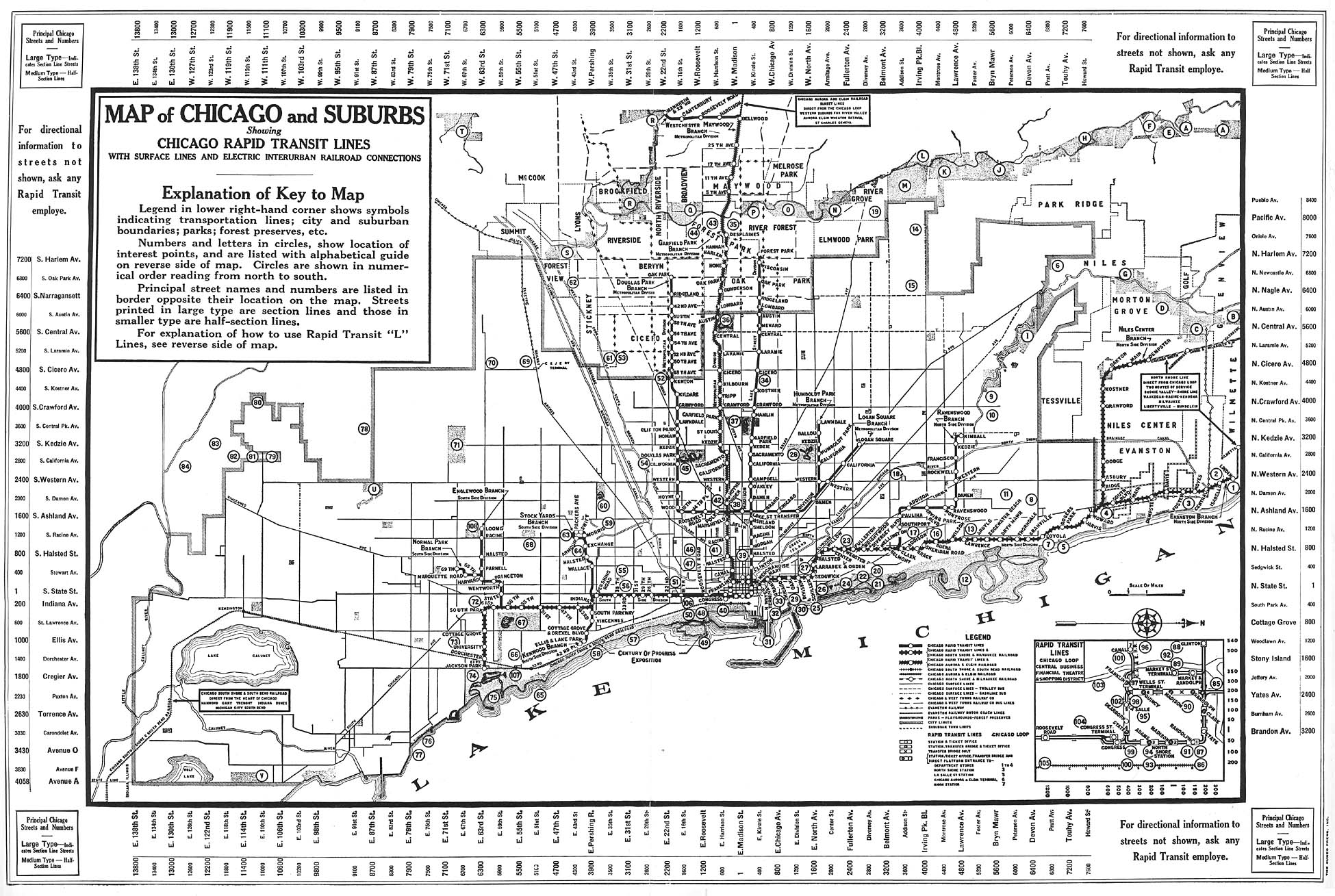
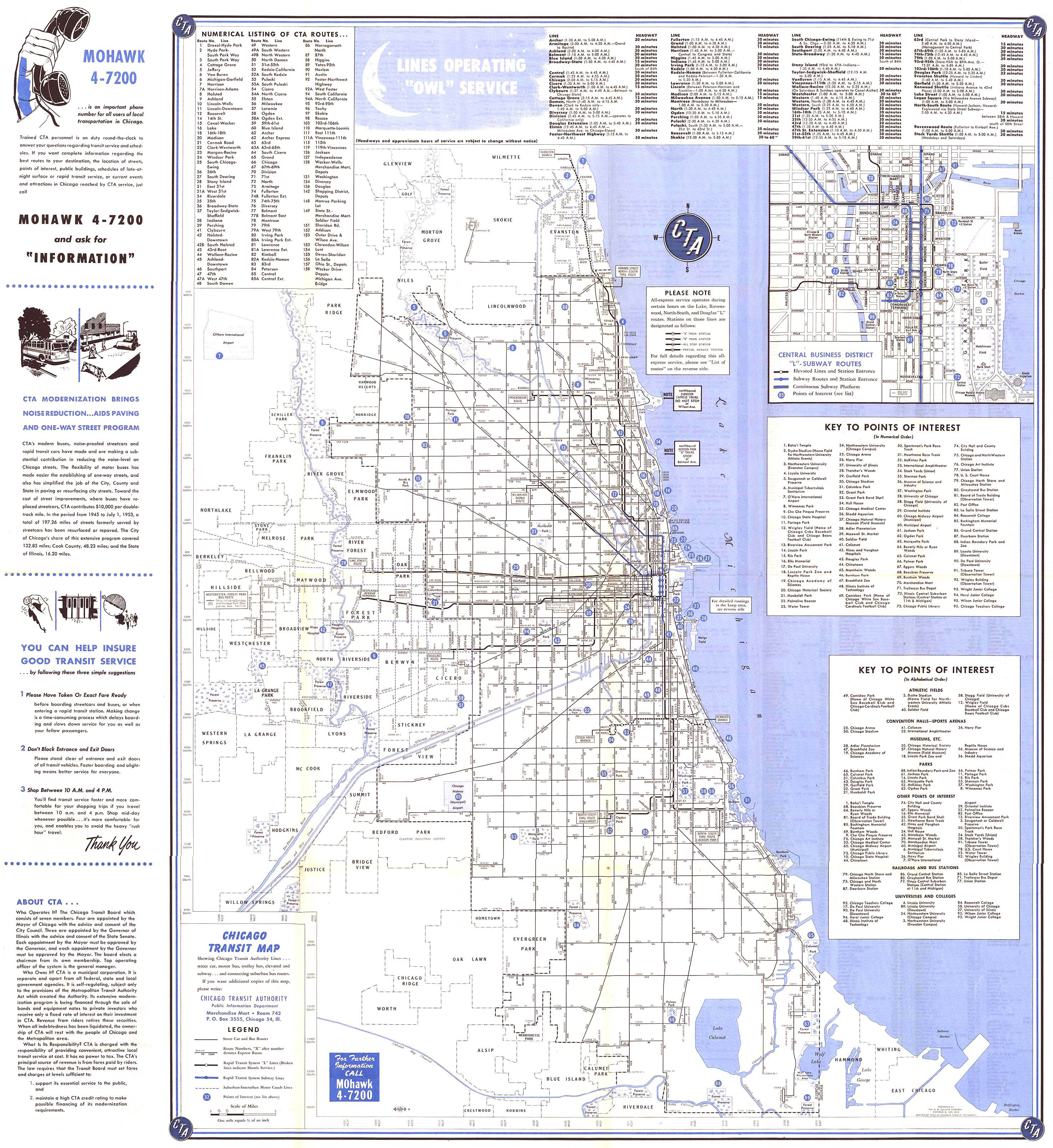
The Chicago "L" is the rapid transit system serving the city of Chicago and some of its surrounding suburbs in the U.S. state of Illinois. Operated by the Chicago Transit Authority (CTA), it is the fourth-largest rapid transit system in the United States in terms of total route length, at 102.8 miles (165.4 km) long as of 2014, and the second-busiest rail mass transit system in the United States, after the New York City Subway. In 2016, the "L" had 1,492 rail cars, eight different routes, and 145 train stations; average weekday ridership was 759,866.

Wells Street Terminal

Wells Street Terminal was a stub-end downtown terminal on the 'L' in Chicago, Illinois, located at Wells Street between Jackson Boulevard and Van Buren Street. The terminal was in operation from 1904 to 1953.

The Chicago Central Area Transit Plan, or generally referred to as the Chicago Central Area Transit Project (CCATP) in the 1970s, was an extensive study of the rapid transit system in downtown Chicago; the study had begun in 1965.

18th station Chicago "L" station

18th is an 'L' station on the CTA's Pink Line. It is located at 1710 West 18th Street in the Pilsen neighborhood of Chicago, Illinois. The station is decorated with colorful murals painted by local artists from Pilsen.

Damen station (CTA Brown Line) Chicago "L" station

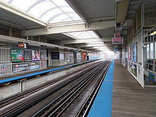
Damen is an 'L' station on the CTA's Brown Line. It is an elevated station with two side platforms, located at 4643–47 North Damen Avenue in Chicago's Ravenswood neighborhood. The adjacent stations are Western, which is located about one half mile (0.8 km) to the west, and Montrose, about one half mile (0.8 km) to the southeast. Located three blocks east is the Ravenswood Metra station on the commuter railroad's Union Pacific/North Line.

Ashland station (CTA Green and Pink Lines) Chicago "L" station

Ashland is an 'L' station on the CTA's Green and Pink Lines. It is an elevated station with two side platforms, located in Chicago's Near West Side neighborhood at 1601 West Lake Street. Just to the west of the station the Pink Line branches off from the Lake Street branch to follow the Paulina Connector to the Cermak branch. The adjacent stations are California (Green), which is located about 1 12 miles (2.4 km) to the west, Polk (Pink), which is located about 1 mile (1.6 km) to the south, and Morgan station, approximately 34 mile (1.2 km) to the east.

Logan Square station Chicago "L" station

Logan Square is a subway station on the Chicago Transit Authority's 'L' system, serving the Blue Line and the Logan Square neighborhood. It was the terminus of the Milwaukee Elevated until it was extended to Jefferson Park in 1970 and to O'Hare Airport in 1984 via the Kennedy Expressway. From Logan Square, trains run at intervals of 2–7 minutes during rush-hour periods, and take 14 minutes to travel to the Loop. O'Hare bound trains take 26 minutes to reach the airport. The interior of the station is very similar to Belmont station, which is the next stop towards O'Hare station.

California station (CTA Blue Line) Chicago "L" station

California is a station on the Chicago Transit Authority's 'L' system, serving the Blue Line, on North California Avenue near West Fullerton Avenue in the Logan Square neighborhood. From California, trains run every 2–7 minutes during rush-hour periods, and take 12 minutes to reach the Loop. It is not to be confused with the California station on the Blue Line's Congress Branch, which permanently closed in 1973.

Western station (CTA Blue Line OHare branch) Chicago "L" station

Western is a station on the Chicago Transit Authority's 'L' system, serving the Blue Line, on North Western Avenue near West Armitage Avenue. The station is located within the Bucktown neighborhood in the larger Logan Square community area. From Western, trains run at intervals of 2-7 minutes during rush-hour periods, and take 10 minutes to reach the Loop.

Damen station (CTA Blue Line) Chicago "L" station

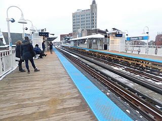
Damen is a station on the Chicago Transit Authority's 'L' system, serving the Blue Line. The station serves the popular and growing Bucktown and Wicker Park neighborhoods. It is the subject of Bert Monroy's famous image Damen. From Damen, trains run at intervals of 2–7 minutes during weekday rush hours, and take 8 minutes to reach the Clark/Lake station in the Loop.

Metropolitan West Side Elevated Railroad

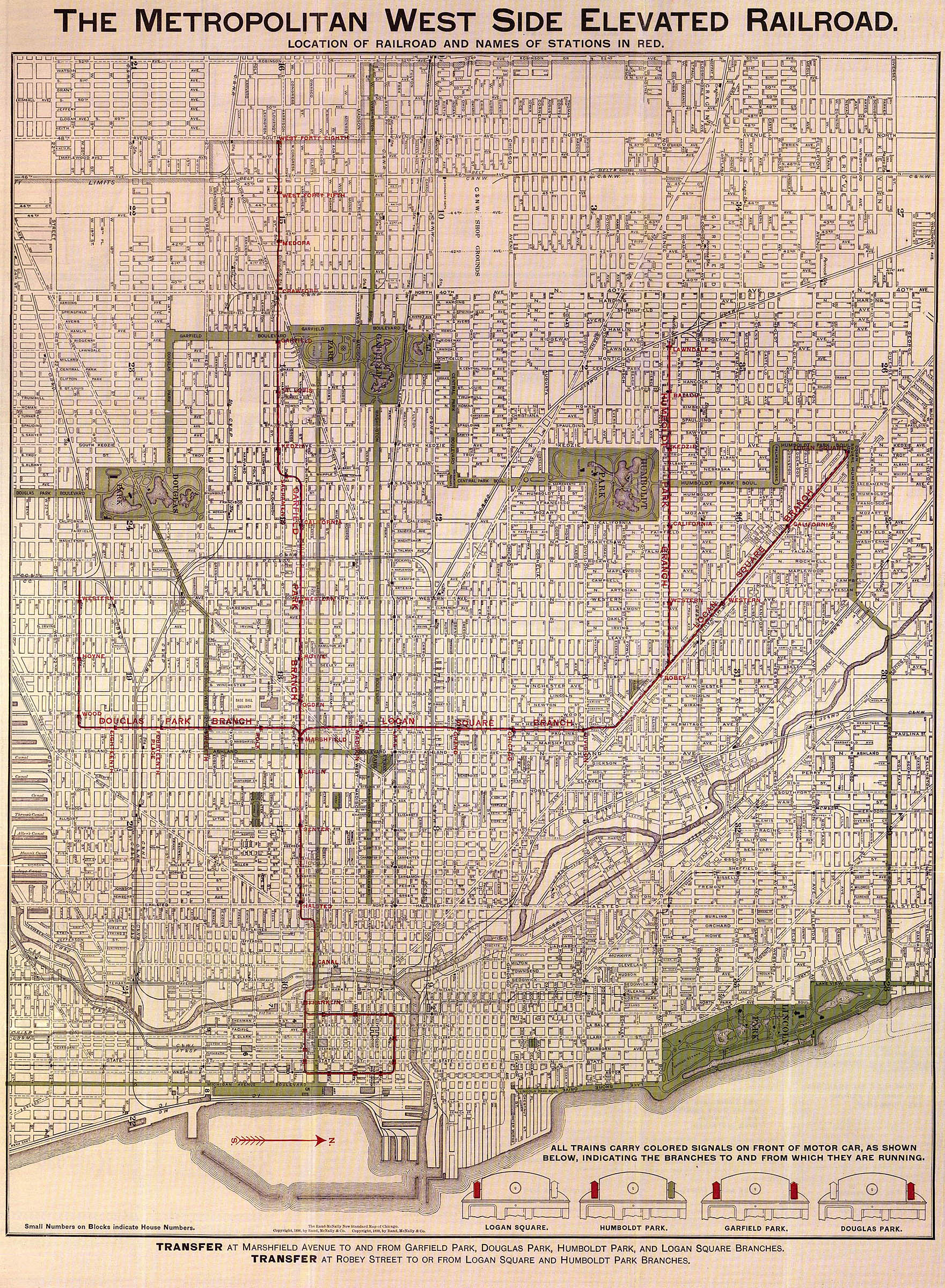
The Metropolitan West Side Elevated Railroad was the third elevated rapid transit line to be built in Chicago, Illinois and was the first of Chicago’s elevated lines to be electrically powered. The line ran from downtown Chicago to Marshfield Avenue with branches to Logan Square, Humboldt Park, Garfield Park, and Douglas Park. Portions of the system are still operated as sections of the Blue Line and the Pink Line.

Metropolitan main line (CTA)

The Metropolitan main line is a defunct rapid transit line which was part of the Chicago "L" system. The line ran west from two downtown terminals, the Wells Street Terminal and the Loop via Franklin/Van Buren, to the Marshfield Junction. At this point the Garfield Park branch continued westward, while the Douglas Park branch turned south, and the Northwest branch turned north to the Humboldt Park branch and Logan Square branch. The Metropolitan main line served eight stations aside from those in the Loop. The line opened on May 6, 1895, and closed on June 22, 1958, upon the opening of the Congress branch.

Milwaukee–Dearborn subway

The Milwaukee–Dearborn subway is an underground section of the Blue Line "L" and is located in the Loop area in Chicago, Illinois. It is 3.85 mi (6.20 km) long and connects the northwest (O'Hare) branch to the southwest branch of the Blue Line. As of February 2013, the branch serves an average of 44,584 passengers each weekday. Since the subway is operated by the Blue Line it serves passengers 24 hours a day/7 days a week and 365 days a year.

Douglas branch

The Douglas branch, also known as the Cermak branch, is a 6.6 mi (10.6 km) long section of the Pink Line of the Chicago "L" system run by the Chicago Transit Authority in Chicago, Illinois built by the Metropolitan West Side Elevated west of the Loop. As of February 2013, it serves an average of 17,474 passengers every weekday. The branch serves the Near West Side, Pilsen, Lower West Side, South Lawndale, and North Lawndale neighborhoods of Chicago, and the west suburb Cicero, Illinois. The branch operates from 4:05 a.m. to 1:25 a.m., weekdays, and Saturdays from 5:05 a.m. to 1:25 a.m., and Sundays from 5:00 a.m. to 1:25 a.m., including holidays.

The Garfield Park Branch was a rapid transit line which was part of the Chicago "L" system from 1895 to 1958. The branch served Chicago's Near West Side, East Garfield Park, West Garfield Park, and Austin neighborhoods, and the suburbs of Oak Park, and Forest Park, and consisted of twenty-two stations. It opened on June 19, 1895 and closed on June 22, 1958, when it was replaced by the Congress branch of the Blue Line.

References

  1. 1 2 "Paulina Connector". Chicago "L".org. Retrieved August 18, 2013.
  2. 1 2 3 'L' Map of Chicago (Map). Chicago Rapid Transit Company. 1934. Retrieved 2013-08-18.
  3. "Logan Square". Chicago "L".org. Retrieved August 16, 2013.
  4. 1 2 "Humboldt Park branch". Chicago "L".org. Retrieved August 16, 2013.
  5. Chicago Transit Map (Map). Chicago Transit Authority. 1954. Retrieved 2013-08-18.
  6. 1 2 Chicago Rapid Transit Map (Map). Chicago Rapid Transit Company. 1946. Retrieved 2013-08-18.
  7. The Metropolitan West Side Elevated Railroad (Map). Metropolitan West Side Elevated Railroad. 1898. Retrieved 2013-08-18.