Norwalk Township, Huron County, Ohio

Last updated

Norwalk Township, Huron County, Ohio
North Coast Inland Trail.jpg
Norwalk Huron.PNG
Location of Norwalk Township (red) in Huron County, next to the city of Norwalk (yellow)
Coordinates: 41°15′5″N82°35′24″W / 41.25139°N 82.59000°W / 41.25139; -82.59000
Country United States
State Ohio
County Huron
Area
  Total
17.7 sq mi (45.8 km2)
  Land17.6 sq mi (45.6 km2)
  Water0.077 sq mi (0.2 km2)
Elevation
[1]
768 ft (234 m)
Population
 (2020) [2]
  Total
3,451
  Density196/sq mi (75.7/km2)
Time zone UTC-5 (Eastern (EST))
  Summer (DST) UTC-4 (EDT)
ZIP code
44857
Area code 419
FIPS code 39-57316 [3]
GNIS feature ID1086353 [1]

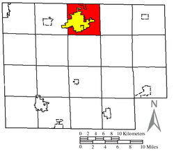
Norwalk Township is one of the nineteen townships of Huron County, Ohio, United States. As of the 2020 census the population of the township was 3,451.

Contents

Geography

Located on the northern edge of the county, it borders the following townships:

Two municipalities are located in Norwalk Township: most of the city of Norwalk — the county seat of Huron County — occupying the majority of the township, and part of the village of Milan in the north.

Name and history

Norwalk Township was named after Norwalk, Connecticut. [4]

It is the only Norwalk Township statewide. [5]

Government

The township is governed by a three-member board of trustees, who are elected in November of odd-numbered years to a four-year term beginning on the following January 1. Two are elected in the year after the presidential election and one is elected in the year before it. There is also an elected township fiscal officer, [6] who serves a four-year term beginning on April 1 of the year after the election, which is held in November of the year before the presidential election. Vacancies in the fiscal officership or on the board of trustees are filled by the remaining trustees.

References

  1. 1 2 "US Board on Geographic Names". United States Geological Survey. October 25, 2007. Retrieved January 31, 2008.
  2. "Norwalk township, Huron County, Ohio - Census Bureau Profile". United States Census Bureau. Retrieved July 12, 2023.
  3. "U.S. Census website". United States Census Bureau . Retrieved January 31, 2008.
  4. Williams, William W. (1879). History of the Fire Lands, Comprising Huron and Erie Counties, Ohio. Press of Leader Printing Company. pp.  111.
  5. "Detailed map of Ohio" (PDF). United States Census Bureau. 2000. Retrieved February 16, 2007.
  6. §503.24, §505.01, and §507.01 of the Ohio Revised Code. Accessed 4/30/2009.